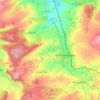
Darmstadt topographic map
Click on the map to display elevation.
About this map
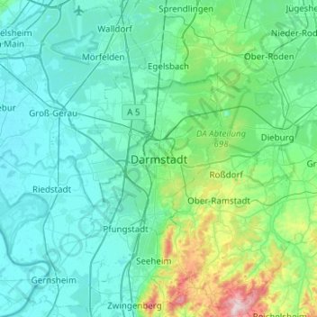
Name: Darmstadt topographic map, elevation, terrain.
Location: Darmstadt, Hesse, 64283, Germany (49.71278 8.49118 50.03278 8.81118)
Average elevation: 495 ft
Minimum elevation: 269 ft
Maximum elevation: 1,982 ft
Other topographic maps
Click on a map to view its topography, its elevation and its terrain.
Rhön
The High Rhön (German: Hohe Rhön or Hochrhön) is that part of the central Rhön that lies in Hesse, Bavaria, and to a lesser extent in Thuringia; it covers an area of 344 km2 (132.8 sq mi) Landscape fact files by the BfN (c.f. section on Natural region division) and is up to 950.0 m (3,117 ft) and whose…
Average elevation: 1,342 ft


Usingen
Germany > Hesse > Hochtaunuskreis
The town core is about 300 m above sea level. The highest elevation in the main town of Usingen is the Hohe Berg ("High Mountain"), 414 m above sea level.
Average elevation: 1,168 ft


Büdingen
Germany > Hesse > Wetteraukreis
Büdingen is in the south of the Wetterau below the Vogelsberg hills at an altitude of approx. 160 meters. The city is situated 15 km northwest of Gelnhausen and about 40 km east from Frankfurt am Main. Historically, the city belongs to Oberhessen.
Average elevation: 712 ft

Hofheim am Taunus
Germany > Hesse > Main-Taunus-Kreis
Hofheim is also described in the Topographia Hassiae.
Average elevation: 650 ft


Beerfelden
Germany > Hesse > Odenwaldkreis > Beerfelden
Beerfelden lies in the Odenwald at elevations from 330 to 540 m. Towards the south stretches the narrow, wooded Gammelsbach Valley, in which are found the Freienstein castle ruins, down to the Neckar.
Average elevation: 1,325 ft