
Salem County topographic map
Click on the map to display elevation.
Salem County
The terrain is almost uniformly flat coastal plain, with minimal relief. The highest elevation in the county has never been determined with any specificity, but is likely one of seven low rises in Upper Pittsgrove Township that reach approximately 160 feet (49 m) in elevation. Sea level is the lowest point.
About this map
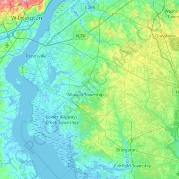
Name: Salem County topographic map, elevation, terrain.
Location: Salem County, New Jersey, United States (39.35592 -75.56339 39.78754 -75.06190)
Average elevation: 59 ft
Minimum elevation: -16 ft
Maximum elevation: 377 ft
New Jersey trails, hiking, mountain biking, running and outdoor activities
Other topographic maps
Click on a map to view its topography, its elevation and its terrain.
Sparta
United States > New Jersey > Sussex County > Sparta Township > Sparta
Average elevation: 906 ft
Stone Tavern
United States > New Jersey > Monmouth County > Upper Freehold Township
Average elevation: 203 ft
Williamstown
United States > New Jersey > Gloucester County > Monroe Township
Average elevation: 144 ft
Green Knoll
United States > New Jersey > Somerset County > Bridgewater Township
Average elevation: 207 ft
Franklin Park
United States > New Jersey > Burlington County > Willingboro Township
Average elevation: 36 ft
Clarksburg
United States > New Jersey > Monmouth County > Millstone Township
Average elevation: 217 ft
Twin Rivers
United States > New Jersey > Mercer County > East Windsor Township
Average elevation: 115 ft
Six Mile Run
United States > New Jersey > Middlesex County > North Brunswick > Adams
Average elevation: 112 ft
Shongum Lake Dam
United States > New Jersey > Morris County > Randolph Township
Average elevation: 837 ft
Mount Pleasant
United States > New Jersey > Monmouth County > Marlboro Township
Average elevation: 190 ft
Orchard Heights
United States > New Jersey > Middlesex County > East Brunswick Township
Average elevation: 105 ft
Chapel Hill
United States > New Jersey > Monmouth County > Middletown Township
Average elevation: 89 ft
Braeburn Heights
United States > New Jersey > Mercer County > Ewing Township
Average elevation: 112 ft
Franklinville
United States > New Jersey > Gloucester County > Franklin Township
Average elevation: 105 ft
Blackwells Mills
United States > New Jersey > Somerset County > Franklin Township
Average elevation: 79 ft
Bradley Gardens
United States > New Jersey > Somerset County > Bridgewater Township
Average elevation: 92 ft
Franklin Park Natural Area
United States > New Jersey > Somerset County > Franklin Township
Average elevation: 131 ft
Shore View
United States > New Jersey > Middlesex County > Woodbridge Township > Colonia
Average elevation: 95 ft
Wertsville
United States > New Jersey > Hunterdon County > East Amwell Township
Average elevation: 236 ft
Rockefellows Mills
United States > New Jersey > Hunterdon County > Raritan Township
Average elevation: 151 ft
Snydertown
United States > New Jersey > Hunterdon County > East Amwell Township
Average elevation: 361 ft
Quakertown
United States > New Jersey > Hunterdon County > Franklin Township
Average elevation: 571 ft
Potterstown
United States > New Jersey > Hunterdon County > Readington Township
Average elevation: 272 ft
Mount Airy
United States > New Jersey > Hunterdon County > West Amwell Township
Average elevation: 259 ft
Linvale
United States > New Jersey > Hunterdon County > East Amwell Township
Average elevation: 358 ft
Larisons Corners
United States > New Jersey > Hunterdon County > East Amwell Township
Average elevation: 217 ft
Dreahook
United States > New Jersey > Hunterdon County > Readington Township
Average elevation: 262 ft
Darts Mills
United States > New Jersey > Hunterdon County > Readington Township
Average elevation: 161 ft
Pleasant Run
United States > New Jersey > Hunterdon County > Readington Township
Average elevation: 207 ft
Three Bridges
United States > New Jersey > Hunterdon County > Readington Township
Average elevation: 157 ft
Eagle Rock Reservation
United States > New Jersey > Essex County > West Orange
Average elevation: 472 ft
Cranberry Hill
United States > New Jersey > Ocean County > Lacey Township > Forked River
Average elevation: 33 ft
Lake Cherokee
United States > New Jersey > Morris County > Randolph Township > Calais Crossroads
Average elevation: 968 ft
Woodland Lake
United States > New Jersey > Morris County > Pequannock Township
Average elevation: 200 ft