
Make a donation
Gear up for your next adventure:
As an Amazon Associate, this site earns from qualifying purchases at no extra cost to you.
Kittatinny Ridge topographic map
Click on the map to display elevation.
Make a donation
Gear up for your next adventure:
As an Amazon Associate, this site earns from qualifying purchases at no extra cost to you.
About this map
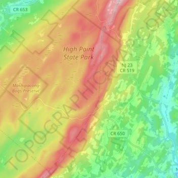
Name: Kittatinny Ridge topographic map, elevation, terrain.
Location: Kittatinny Ridge, Sussex County, New Jersey, United States (41.21823 -74.72048 41.32113 -74.66157)
Average elevation: 997 ft
Minimum elevation: 427 ft
Maximum elevation: 1,759 ft
New Jersey trails, hiking, mountain biking, running and outdoor activities
Make a donation
Gear up for your next adventure:
As an Amazon Associate, this site earns from qualifying purchases at no extra cost to you.
Other topographic maps
Click on a map to view its topography, its elevation and its terrain.
Salem County
The terrain is almost uniformly flat coastal plain, with minimal relief. The highest elevation in the county has never been determined with any specificity, but is likely one of seven low rises in Upper Pittsgrove Township that reach approximately 160 feet (49 m) in elevation. Sea level is the lowest point.
Average elevation: 59 ft
Mercer County
The county is generally flat and low-lying on the inner coastal plain, which extends up to the Route 1 corridor. Further northwest, terrain rises as it ascends the Piedmont Plateau, with The Sourlands encompassing the far northwestern portion of the county. Baldpate Mountain, in the western part of Hopewell…
Average elevation: 141 ft
Make a donation
Gear up for your next adventure:
As an Amazon Associate, this site earns from qualifying purchases at no extra cost to you.
Make a donation
Gear up for your next adventure:
As an Amazon Associate, this site earns from qualifying purchases at no extra cost to you.
Sparta
United States > New Jersey > Sussex County > Sparta Township > Sparta
Average elevation: 906 ft
Make a donation
Gear up for your next adventure:
As an Amazon Associate, this site earns from qualifying purchases at no extra cost to you.
Franklin Park
United States > New Jersey > Burlington County > Willingboro Township
Average elevation: 36 ft
Make a donation
Gear up for your next adventure:
As an Amazon Associate, this site earns from qualifying purchases at no extra cost to you.
Oakhurst
United States > New Jersey > Monmouth County > Ocean Township
According to the United States Census Bureau, the CDP had a total area of 1.614 square miles (4.178 km2), including 1.611 square miles (4.171 km2) of land and 0.003 square miles (0.006 km2) of water (0.16%). The CDP also has an elevation of 46 feet above sea level.
Average elevation: 49 ft
Make a donation
Gear up for your next adventure:
As an Amazon Associate, this site earns from qualifying purchases at no extra cost to you.
Jersey Shore Region
United States > New Jersey > Monmouth County > Wall Township
Average elevation: 52 ft
Make a donation
Gear up for your next adventure:
As an Amazon Associate, this site earns from qualifying purchases at no extra cost to you.
Clarksburg
United States > New Jersey > Monmouth County > Millstone Township
Average elevation: 217 ft
Make a donation
Gear up for your next adventure:
As an Amazon Associate, this site earns from qualifying purchases at no extra cost to you.
Twin Rivers
United States > New Jersey > Mercer County > East Windsor Township
Average elevation: 115 ft
Holiday Heights
United States > New Jersey > Ocean County > Berkeley Township
Average elevation: 52 ft
Make a donation
Gear up for your next adventure:
As an Amazon Associate, this site earns from qualifying purchases at no extra cost to you.
Cedar Glen Lakes
United States > New Jersey > Ocean County > Manchester Township > Cedar Glen Lakes
Average elevation: 154 ft
Leonardo
United States > New Jersey > Monmouth County > Middletown Township > Leonardo
Average elevation: 20 ft
Make a donation
Gear up for your next adventure:
As an Amazon Associate, this site earns from qualifying purchases at no extra cost to you.
Princeton Meadows
United States > New Jersey > Middlesex County > Plainsboro Township
Average elevation: 89 ft
Cedar Glen West
United States > New Jersey > Ocean County > Manchester Township > Cedar Glen West
Average elevation: 79 ft
Plainsboro Center
United States > New Jersey > Middlesex County > Plainsboro Township > Plainsboro Center
Average elevation: 82 ft
Make a donation
Gear up for your next adventure:
As an Amazon Associate, this site earns from qualifying purchases at no extra cost to you.
Cherry Hill Mall
United States > New Jersey > Camden County > Cherry Hill Township
Average elevation: 52 ft
Laurel Lake
United States > New Jersey > Cumberland County > Commercial Township
Average elevation: 36 ft
Make a donation
Gear up for your next adventure:
As an Amazon Associate, this site earns from qualifying purchases at no extra cost to you.
Make a donation
Gear up for your next adventure:
As an Amazon Associate, this site earns from qualifying purchases at no extra cost to you.
Shongum Lake Dam
United States > New Jersey > Morris County > Randolph Township
Average elevation: 837 ft
Mount Pleasant
United States > New Jersey > Monmouth County > Marlboro Township
Average elevation: 190 ft
Make a donation
Gear up for your next adventure:
As an Amazon Associate, this site earns from qualifying purchases at no extra cost to you.
Orchard Heights
United States > New Jersey > Middlesex County > East Brunswick Township
Average elevation: 105 ft
Make a donation
Gear up for your next adventure:
As an Amazon Associate, this site earns from qualifying purchases at no extra cost to you.
Cape May Court House
United States > New Jersey > Cape May County > Cape May Court House
Average elevation: 10 ft
Chapel Hill
United States > New Jersey > Monmouth County > Middletown Township
Average elevation: 89 ft
Stone Tavern
United States > New Jersey > Monmouth County > Upper Freehold Township
Average elevation: 203 ft
Make a donation
Gear up for your next adventure:
As an Amazon Associate, this site earns from qualifying purchases at no extra cost to you.
Braeburn Heights
United States > New Jersey > Mercer County > Ewing Township
Average elevation: 112 ft
South Orange
United States > New Jersey > Essex County
The western part of the town sits on the eastern slope of South Mountain (elevation <660 feet (201 m)), leveling into a small valley near the central business district. At the top of the slope, the western edge of the town runs along the eastern border of South Mountain Reservation. South Orange contains the…
Average elevation: 308 ft
Make a donation
Gear up for your next adventure:
As an Amazon Associate, this site earns from qualifying purchases at no extra cost to you.
Budd Lake
United States > New Jersey > Morris County > Mount Olive > Budd Lake
Budd Lake, which the community is named after, is the source of the South Branch Raritan River. A glacial lake at an elevation of 933 feet (284 m), Budd Lake has a surface area of 374 acres (1.51 km2). It is 7–12 feet deep, and can have large algal blooms. The bog, created by thousands of years of decaying…
Average elevation: 1,027 ft
Franklinville
United States > New Jersey > Gloucester County > Franklin Township
Average elevation: 105 ft
Blackwells Mills
United States > New Jersey > Somerset County > Franklin Township
Average elevation: 79 ft
Bradley Gardens
United States > New Jersey > Somerset County > Bridgewater Township
Average elevation: 92 ft
Make a donation
Gear up for your next adventure:
As an Amazon Associate, this site earns from qualifying purchases at no extra cost to you.
Franklin Park Natural Area
United States > New Jersey > Somerset County > Franklin Township
Average elevation: 131 ft
Make a donation
Gear up for your next adventure:
As an Amazon Associate, this site earns from qualifying purchases at no extra cost to you.
Shore View
United States > New Jersey > Middlesex County > Woodbridge Township > Colonia
Average elevation: 95 ft
Make a donation
Gear up for your next adventure:
As an Amazon Associate, this site earns from qualifying purchases at no extra cost to you.
Wertsville
United States > New Jersey > Hunterdon County > East Amwell Township
Average elevation: 236 ft
Rockefellows Mills
United States > New Jersey > Hunterdon County > Raritan Township
Average elevation: 151 ft
Make a donation
Gear up for your next adventure:
As an Amazon Associate, this site earns from qualifying purchases at no extra cost to you.
Make a donation
Gear up for your next adventure:
As an Amazon Associate, this site earns from qualifying purchases at no extra cost to you.
Snydertown
United States > New Jersey > Hunterdon County > East Amwell Township
Average elevation: 361 ft
Quakertown
United States > New Jersey > Hunterdon County > Franklin Township
Average elevation: 571 ft
Make a donation
Gear up for your next adventure:
As an Amazon Associate, this site earns from qualifying purchases at no extra cost to you.
Potterstown
United States > New Jersey > Hunterdon County > Readington Township
Average elevation: 272 ft
Make a donation
Gear up for your next adventure:
As an Amazon Associate, this site earns from qualifying purchases at no extra cost to you.
Make a donation
Gear up for your next adventure:
As an Amazon Associate, this site earns from qualifying purchases at no extra cost to you.
Mount Airy
United States > New Jersey > Hunterdon County > West Amwell Township
Average elevation: 259 ft
Linvale
United States > New Jersey > Hunterdon County > East Amwell Township
Average elevation: 358 ft
Make a donation
Gear up for your next adventure:
As an Amazon Associate, this site earns from qualifying purchases at no extra cost to you.