
Make a donation
Gear up for your next adventure:
As an Amazon Associate, this site earns from qualifying purchases at no extra cost to you.
Dedza topographic map
Click on the map to display elevation.
Make a donation
Gear up for your next adventure:
As an Amazon Associate, this site earns from qualifying purchases at no extra cost to you.
Dedza
The western part of the district is on the Central African Plateau at an altitude of 1 200 to 1,600 m. Higher mountain ranges separate this from land alongside Lake Malawi in the Rift Valley at 500 m. The landscape is a mixture of grassland with granite outcrops, natural woodland and commercial pine plantations on the mountains and some bamboo forest nearer the lake. The wet season is November to April with almost no rainfall at other times. The higher altitudes have moderate temperatures and can be cold in June and July.
Make a donation
Gear up for your next adventure:
As an Amazon Associate, this site earns from qualifying purchases at no extra cost to you.
About this map
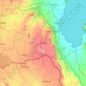
Name: Dedza topographic map, elevation, terrain.
Location: Dedza, Central Region, Malawi, Malawi (-14.61663 33.65006 -13.85837 34.74286)
Average elevation: 3,186 ft
Minimum elevation: 1,545 ft
Maximum elevation: 7,028 ft
Make a donation
Gear up for your next adventure:
As an Amazon Associate, this site earns from qualifying purchases at no extra cost to you.
Other topographic maps
Click on a map to view its topography, its elevation and its terrain.
Blantyre
From 1876 to 1905, urban development in Blantyre was confined to three distinct areas within 2 km of each other: Blantyre Mission, Mandala (European commercial venture), and the government zone and commercial centre triangle marked by Haile Selassie Road, Glyn Jones Road and Hannover Street. In Limbe…
Average elevation: 2,861 ft
Make a donation
Gear up for your next adventure:
As an Amazon Associate, this site earns from qualifying purchases at no extra cost to you.
Make a donation
Gear up for your next adventure:
As an Amazon Associate, this site earns from qualifying purchases at no extra cost to you.
Make a donation
Gear up for your next adventure:
As an Amazon Associate, this site earns from qualifying purchases at no extra cost to you.
Make a donation
Gear up for your next adventure:
As an Amazon Associate, this site earns from qualifying purchases at no extra cost to you.
Blantyre
From 1876 to 1905, urban development in Blantyre was confined to three distinct areas within 2 km of each other: Blantyre Mission, Mandala (European commercial venture), and the government zone and commercial centre triangle marked by Haile Selassie Road, Glyn Jones Road and Hannover Street. In Limbe…
Average elevation: 2,861 ft
Make a donation
Gear up for your next adventure:
As an Amazon Associate, this site earns from qualifying purchases at no extra cost to you.
Kasungu National Park
Kasungu National Park, established in 1970, is the second-largest in Malawi at 2,316 square kilometres (894 sq mi), with an elevation of approximately 1,000 metres (3,300 ft) above sea level on average. It is located in the Central Region approximately 165 km (103 mi) north of Lilongwe.
Average elevation: 3,566 ft
Make a donation
Gear up for your next adventure:
As an Amazon Associate, this site earns from qualifying purchases at no extra cost to you.
Make a donation
Gear up for your next adventure:
As an Amazon Associate, this site earns from qualifying purchases at no extra cost to you.
Make a donation
Gear up for your next adventure:
As an Amazon Associate, this site earns from qualifying purchases at no extra cost to you.
Make a donation
Gear up for your next adventure:
As an Amazon Associate, this site earns from qualifying purchases at no extra cost to you.
Make a donation
Gear up for your next adventure:
As an Amazon Associate, this site earns from qualifying purchases at no extra cost to you.