Geolocate

Cowlitz County topographic map

Interactive map

Click on the map to display elevation.

About this map

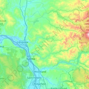
Name: Cowlitz County topographic map, elevation, terrain.

Location: Cowlitz County, Washington, United States (45.85064 -123.22057 46.38623 -122.23995)

Average elevation: 1,178 ft

Minimum elevation: -13 ft

Maximum elevation: 7,726 ft

Routes: Washington GPS tracks, routes, trails, hikes

Other topographic maps

Click on a map to view its topography, its elevation and its terrain.

Seattle

United States > Washington > King County

Seattle features a diverse topography characterized by its unique geographical setting between Puget Sound and Lake Washington. The city is situated on an isthmus, which contributes to its dramatic landscape, featuring rolling hills and steep slopes that rise abruptly from the waterfront. The average elevation…

Average elevation: 131 ft

Edmonds

United States > Washington > Snohomish County

Average elevation: 144 ft

Olympic Peninsula

United States > Washington

The Olympic Peninsula is characterized by its striking topography, which features a dramatic interplay of mountains, forests, and coastline. At its center, the Olympic Mountains rise sharply, with peaks like Mount Olympus reaching elevations of 7,965 feet (2,428 meters) and boasting significant glaciation due…

Average elevation: 751 ft

Aberdeen

United States > Washington > Grays Harbor County > Aberdeen

Aberdeen is at the eastern end of Grays Harbor, near the mouth of the Chehalis River and southwest of the Olympic Mountains. Grays Harbor is notable as the northernmost ria on North America's Pacific Coast because it has remained free of glaciers throughout the Quaternary due to unfavorable topography and warm…

Average elevation: 217 ft

Kirkland

United States > Washington > King County

According to the United States Census Bureau, the city has a total area of 17.83 square miles (46.18 km2), of which 17.818 square miles (46.15 km2) are land and 0.012 square miles (0.03 km2) are water. The elevation varies from 14 to 500 feet (150 m) above sea level.

Average elevation: 190 ft

Olympia

United States > Washington > Thurston County

Average elevation: 161 ft

Longview

United States > Washington > Cowlitz County

Longview is located in a small gorge, so its climate varies from that of its close neighbor, Portland. Longview is generally about 7 °F (4 °C) cooler than Portland. Located about 80 miles (130 km) inland across a stretch of relatively flat ground, the Longview skies can be overcast due to moisture from the…

Average elevation: 164 ft

Sammamish

United States > Washington > King County

Average elevation: 318 ft

Pullman

United States > Washington > Whitman County

Pullman is situated within the Palouse region, characterized by its distinct topography of rolling hills formed from loess deposits—windblown silt accumulated over millennia. The city's average elevation is approximately 2,540 feet (774 meters), with elevations ranging from about 2,342 to 2,575 feet (714 to…

Average elevation: 2,539 ft

Mount Rainier National Park

United States > Washington > Pierce County

Mount Rainier National Park is an American national park located in southeast Pierce County and northeast Lewis County in Washington state. The park was established on March 2, 1899 as the fifth national park in the United States, preserving 236,381 acres (369.3 sq mi; 956.6 km2) including all of Mount…

Average elevation: 4,633 ft

Whidbey Island

United States > Washington > Island County

Whidbey Island features a diverse topography characterized by a mix of rolling hills, lush forests, and dramatic coastal cliffs. The island stretches approximately 55 miles in length and up to 12 miles wide, rising to elevations of about 500 feet at its highest point. Its terrain includes expansive farmland…

Average elevation: 148 ft

Spokane

United States > Washington > Spokane County

Spokane is located on the Spokane River in eastern Washington at an elevation of 1,843 feet (562 m) above sea level, about 18 miles (29 km) from Idaho, 92 miles (148 km) south of the Canadian border, 229 miles (369 km) due east of Seattle, and 279 miles (449 km) southwest of Calgary. The lowest elevation in…

Average elevation: 2,149 ft

Vashon Island

United States > Washington > King County > Vashon

Vashon Island features a diverse topography characterized by rolling hills, lush forests, and scenic waterfronts. The island rises gently from sea level to elevations reaching around 500 feet (approximately 150 meters) at its highest point, providing sweeping views of Puget Sound and the surrounding mountains.…

Average elevation: 151 ft

Lacey

United States > Washington > Thurston County

Average elevation: 154 ft

Gig Harbor

United States > Washington > Pierce County

Average elevation: 161 ft

Queen Anne Hill

United States > Washington > King County > Seattle

Average elevation: 180 ft

Kittitas County

United States > Washington

Average elevation: 3,031 ft

Snohomish County

United States > Washington

The lowland areas of western Snohomish County generally has a temperate Mediterranean climate similar to the rest of the central Puget Sound region with dry summers and wet winters. The county's weather is heavily influenced by maritime systems, pushed by prevailing westerly winds but dampened by the Olympic…

Average elevation: 2,129 ft

Issaquah

United States > Washington > King County

Average elevation: 538 ft

Port Orchard

United States > Washington > Kitsap County

Average elevation: 233 ft

Renton

United States > Washington > King County

Average elevation: 272 ft

Wenatchee

United States > Washington > Chelan County

Wenatchee is characterized by its diverse topography, nestled at an average elevation of approximately 800 feet. The city is situated in a valley surrounded by significant geographical features, including the rugged foothills of the Cascade Mountains, which rise sharply to elevations of over 4,500 feet just to…

Average elevation: 991 ft

Federal Way

United States > Washington > King County

Average elevation: 266 ft

Port Angeles

United States > Washington > Clallam County

Average elevation: 89 ft

Arlington

United States > Washington > Snohomish County

The city lies on a glacial terrace formed during the Pleistocene epoch by the recession of the Cordilleran Ice Sheet. Arlington covers a series of hills that sit at an elevation of 100 to 200 feet (30 to 61 m) above sea level. Downtown Arlington is situated on a bluff above the confluence of the Stillaguamish…

Average elevation: 197 ft

Marysville

United States > Washington > Snohomish County

The city's topography varies from the low-lying downtown, located along the banks of Ebey Slough 5 feet (1.5 m) above sea level, rising to 160 feet (49 m) near Smokey Point and over 465 feet (142 m) in the eastern highlands. Marysville sits in the watershed of two major creeks, Quilceda Creek and Allen Creek,…

Average elevation: 236 ft

Redmond

United States > Washington > King County

Redmond features a diverse topography characterized by its gently rolling hills and lush landscapes. The city lies at an average elevation of approximately 250 feet (76 meters) above sea level, with elevations varying between 15 feet (5 meters) to about 500 feet (152 meters) across the region​. This varied…

Average elevation: 236 ft

Orcas Island

United States > Washington > San Juan County > Eastsound

Mount Constitution (elevation 2409 feet/734 meters) is the highest point in the San Juan islands. The mountain is part of Moran State Park, the largest public recreation area in the San Juan Islands, and the largest State Park in Washington. Moran State Park encompasses over 5,000 acres (2,000 ha) of woodland…

Average elevation: 194 ft

Bellingham

United States > Washington > Whatcom County

Bellingham is characterized by a diverse and striking topography that combines coastal and mountainous landscapes. The city lies along the eastern shore of Bellingham Bay, where the waters of the Puget Sound meet the foothills of the Cascade Range. Rising abruptly from the shoreline, the surrounding hills and…

Average elevation: 292 ft

Oak Harbor

United States > Washington > Island County

Average elevation: 102 ft

Sequim

United States > Washington > Clallam County

Average elevation: 289 ft

North Bend

United States > Washington > King County

Average elevation: 525 ft

Bonney Lake

United States > Washington > Pierce County

Average elevation: 499 ft

Anacortes

United States > Washington > Skagit County

Average elevation: 118 ft

Everett

United States > Washington > Snohomish County

Average elevation: 226 ft

Bremerton

United States > Washington > Kitsap County

Average elevation: 223 ft

Kennewick

United States > Washington > Benton County

Native Americans populated the area around modern-day Kennewick for millennia before being discovered and settled by European descendants. These inhabitants consisted of people from the Umatilla, Wanapum, Nez Perce, and Yakama tribes. Kennewick's low elevation helped to moderate winter temperatures. On top of…

Average elevation: 502 ft

Selleck

United States > Washington > King County

Average elevation: 1,083 ft

Pear Butte

United States > Washington

Average elevation: 5,308 ft

Leavenworth

United States > Washington > Chelan County

Average elevation: 1,371 ft

Olympic National Park

United States > Washington > Jefferson County

Views of the Olympic National Park can be seen from the Hurricane Ridge viewpoint. The road leading west from the Hurricane Ridge visitor center has several picnic areas and trailheads. A paved trail called the Hurricane Hill trail is about 1.6 miles (2.6 km) long each way, with an elevation gain of about 700…

Average elevation: 1,352 ft

Washougal

United States > Washington > Clark County

Average elevation: 164 ft

Snoqualmie

United States > Washington > King County

Snoqualmie is located at 47°31′59″N 121°50′40″W / 47.53306°N 121.84444°W / 47.53306; -121.84444 (47.532934, -121.844341), at an elevation of 410 feet (120 m) above MSL.

Average elevation: 699 ft

Monroe

United States > Washington > Snohomish County

The city lies at the eastern end of the Snohomish River floodplain, with elevations that range from 40 to 210 feet (12 to 64 m). The south and east edges of the city along the Skykomish River are within a 100-year flood hazard zone and also include habitats for migratory birds and game animals. The residential…

Average elevation: 161 ft