
Make a donation
Gear up for your next adventure:
As an Amazon Associate, this site earns from qualifying purchases at no extra cost to you.
Pasadena topographic map
Click on the map to display elevation.
Make a donation
Gear up for your next adventure:
As an Amazon Associate, this site earns from qualifying purchases at no extra cost to you.
Pasadena
Pasadena is located at 39°6′46″N 76°33′7″W / 39.11278°N 76.55194°W / 39.11278; -76.55194 (39.112809, −76.551871) in northern Anne Arundel County. It is bordered to the north by the city of Baltimore, to the east by the tidal Patapsco River and by Riviera Beach, to the southeast by Lake Shore, to the south by Severna Park, and to the west by Glen Burnie. The original community of Pasadena, shown on USGS topographic maps at the intersection of Pasadena Road and Governor Ritchie Highway (Maryland Route 2), is now assigned by the U.S. Census Bureau to the Severna Park census-designated place, south of the border for the Pasadena CDP, which itself is centered along Mountain Road (Maryland Route 177) and includes the neighborhoods of Ashburn and Green Haven, and extends north along the Marley Neck peninsula all the way to the Baltimore city line.
Make a donation
Gear up for your next adventure:
As an Amazon Associate, this site earns from qualifying purchases at no extra cost to you.
About this map
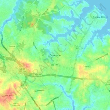
Name: Pasadena topographic map, elevation, terrain.
Average elevation: 52 ft
Minimum elevation: -7 ft
Maximum elevation: 151 ft
Anne Arundel County trails, hiking, mountain biking, running and outdoor activities
Make a donation
Gear up for your next adventure:
As an Amazon Associate, this site earns from qualifying purchases at no extra cost to you.
Other topographic maps
Click on a map to view its topography, its elevation and its terrain.
Franklin Point State Park
United States > Maryland > Anne Arundel County > Columbia Beach
Average elevation: 3 ft
Magothy River
United States > Maryland > Anne Arundel County > Severna Park
Almost all of the creeks and tidal coves on the Magothy are named, partly as the result of a project started in 2001 by the Magothy River Association. They are shown on a map produced as part of that project, and the major ones are shown on the USGS topographic map.
Average elevation: 30 ft
Make a donation
Gear up for your next adventure:
As an Amazon Associate, this site earns from qualifying purchases at no extra cost to you.
Cape St. Claire
United States > Maryland > Anne Arundel County > Cape Saint Claire
Average elevation: 39 ft
Make a donation
Gear up for your next adventure:
As an Amazon Associate, this site earns from qualifying purchases at no extra cost to you.
Forked Creek
United States > Maryland > Anne Arundel County > Arnold > Kimberly Woods Village
Average elevation: 72 ft
Magothy Greenway
United States > Maryland > Anne Arundel County > North Shore
Average elevation: 23 ft
Fort Smallwood Park
United States > Maryland > Anne Arundel County > Riviera Beach > Rockwood Beach
Average elevation: 7 ft
Make a donation
Gear up for your next adventure:
As an Amazon Associate, this site earns from qualifying purchases at no extra cost to you.