
Småland topographic map
Interactive map
Click on the map to display elevation.
About this map
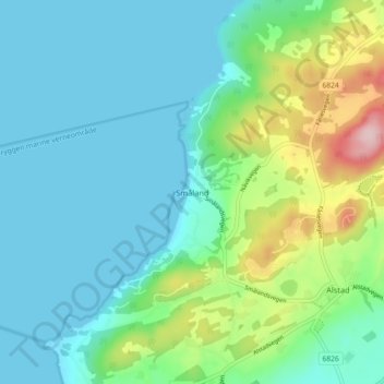
Name: Småland topographic map, elevation, terrain.
Location: Småland, Frosta, Trøndelag, 7633, Norway (63.57767 10.68614 63.61767 10.72614)
Average elevation: 161 ft
Minimum elevation: 0 ft
Maximum elevation: 712 ft
Other topographic maps
Click on a map to view its topography, its elevation and its terrain.