
Palamaner topographic map
Click on the map to display elevation.
About this map
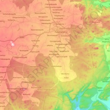
Name: Palamaner topographic map, elevation, terrain.
Location: Palamaner, Chittoor, Andhra Pradesh, India (13.05409 78.63941 13.24994 78.87655)
Average elevation: 2,083 ft
Minimum elevation: 1,066 ft
Maximum elevation: 2,897 ft
Other topographic maps
Click on a map to view its topography, its elevation and its terrain.
Guntakal
India > Andhra Pradesh > Guntakal
Guntakal is located at 15°10′N 77°23′E / 15.17°N 77.38°E / 15.17; 77.38. It has an average elevation of 432 metres (1,417 ft).
Average elevation: 1,460 ft
Machilipatnam
India > Andhra Pradesh > Machilipatnam > Machilipatnam
Machilipatnam city is at 16°10′N 81°08′E / 16.17°N 81.13°E / 16.17; 81.13 on the southeast coast of India and in the east coast of Andhra Pradesh. The city has an average elevation of 14 meters (45 feet).
Average elevation: 13 ft
Mangalagiri
India > Andhra Pradesh > Mangalagiri > Mangalagiri
Mangalagiri is located at 16°26′N 80°33′E / 16.43°N 80.55°E / 16.43; 80.55. It has an average elevation of 29.08 m (95.4 ft).It is located 26 kilometres (16 mi) north east of the district headquarters, Guntur, and just 10 km (6.2 mi) south west of Vijayawada and also 30 km (19 mi) to the north…
Average elevation: 95 ft