
County Louth topographic map
Interactive map
Click on the map to display elevation.
About this map
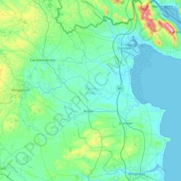
Name: County Louth topographic map, elevation, terrain.
Location: County Louth, Leinster, Ireland (53.69850 -6.69541 54.11395 -6.10324)
Average elevation: 233 ft
Minimum elevation: -3 ft
Maximum elevation: 1,900 ft
Other topographic maps
Click on a map to view its topography, its elevation and its terrain.
Costelloe
Costelloe, Conamara Municipal District, County Galway, Connacht, H91 A2T6, Ireland
Average elevation: 39 ft
Athlone
Athlone, County Westmeath, Leinster, Ireland
Average elevation: 141 ft
Lismore
Lismore, The Municipal District of Dungarvan — Lismore, County Waterford, Munster, P51 VW44, Ireland
Average elevation: 125 ft
Kilmichael
Kilmichael, Carrigboy ED, Municipal District of Macroom, County Cork, Munster, P12 W864, Ireland
Average elevation: 436 ft
Macroom
Macroom, Municipal District of Macroom, County Cork, Munster, Ireland
Average elevation: 361 ft
Great Skellig
Great Skellig, Kenmare Municipal District, County Kerry, Munster, Ireland
Average elevation: 3 ft
Boston
Boston, Boston ED, West Clare Municipal District, County Clare, Munster, H91 R9FX, Ireland
Average elevation: 82 ft
Cashel
Cashel, The Municipal District of Cahir — Cashel, County Tipperary, Munster, Ireland
Average elevation: 377 ft
Acres
Acres, Aghavas ED, Ballinamore Municipal District, County Leitrim, Connacht, Ireland
Average elevation: 243 ft
Curraghboy
Curraghboy, Rockhill Electoral Division, Athlone Municipal District, County Roscommon, Connacht, N37 EK20, Ireland
Average elevation: 226 ft
Furbo
Furbo, County Galway, Connacht, H91 KX27, Ireland
Average elevation: 52 ft
Headford
Headford, Headford ED, Tuam Municipal District, County Galway, Connacht, Ireland
Average elevation: 66 ft
Curtaun
Curtaun, Beagh ED, Loughrea Municipal District, County Galway, Connacht, Ireland
Average elevation: 89 ft
Leamlara
Leamlara, Lisgoold, The Municipal District of East Cork, County Cork, Munster, T56 NH57, Ireland
Average elevation: 476 ft
Naas
Naas, The Municipal District of Naas, County Kildare, Leinster, Ireland
Average elevation: 318 ft
Killeens
Killeens, Coolhill, The Municipal District of Callan — Thomastown, County Kilkenny, Leinster, Ireland
Average elevation: 207 ft
Lecks
Lecks, Shercock ED, Bailieborough-Cootehill Municipal District, County Cavan, Ireland
Average elevation: 420 ft
Ballybrack
Ireland > County Dublin > Killiney
Ballybrack, Killiney North DED 1986, Killiney, Dún Laoghaire-Rathdown, County Dublin, Leinster, Ireland
Average elevation: 105 ft
Manorhamilton Municipal District
Manorhamilton Municipal District, County Leitrim, Connacht, Ireland
Average elevation: 512 ft
Matehy
Matehy, Municipal District of Macroom, County Cork, Munster, Ireland
Average elevation: 351 ft
Keshcarrigan
Keshcarrigan, Ballinamore Municipal District, County Leitrim, Connacht, Ireland
Average elevation: 256 ft
Kiltegan
Kiltegan, The Municipal District of Baltinglass, County Wicklow, Leinster, Ireland
Average elevation: 492 ft
Newmarket
Newmarket, The Municipal District of Kanturk-Mallow, County Cork, Munster, Ireland
Average elevation: 554 ft
Killarney
Killarney, Killarney Municipal District, County Kerry, Munster, Ireland
Average elevation: 187 ft
Newbridge
Newbridge, The Municipal District of Kildare — Newbridge, County Kildare, Leinster, Ireland
Average elevation: 312 ft
Mullyash
Mullyash, Mullyash ED, Carrickmacross-Castleblaney Municipal District, County Monaghan, Ulster, Ireland
Average elevation: 725 ft
Watergrasshill
Watergrasshill, Municipal District of Cobh, County Cork, Munster, Ireland
Average elevation: 538 ft
Horseleap
Horseleap, The Municipal District of Tullamore, County Offaly, Leinster, Ireland
Average elevation: 230 ft
Claremorris-Swinford Municipal District
Claremorris-Swinford Municipal District, County Mayo, Connacht, Ireland
Average elevation: 226 ft
White River
White River, Dunleer ED, The Municipal District of Ardee, County Louth, Leinster, A92 RP77, Ireland
Average elevation: 246 ft
Cork City
Ireland > County Cork > Cork
Cork City, Cork, County Cork, Munster, Ireland
Average elevation: 217 ft
Bellananagh
Bellananagh, Bellananagh ED, Ballyjamesduff Municipal District, County Cavan, H12 K727, Ireland
Average elevation: 308 ft
Gurteen
Gurteen, Cappalusk ED, Athenry-Oranmore Municipal District, County Galway, Connacht, Ireland
Average elevation: 292 ft
Carrickmines Little
Ireland > County Dublin > Ballyogan
Carrickmines Little, Glencullen Electoral Division, Ballyogan, Dún Laoghaire-Rathdown, County Dublin, Leinster, Ireland
Average elevation: 272 ft
Cahir
Cahir, The Municipal District of Cahir — Cashel, County Tipperary, Munster, Ireland
Average elevation: 190 ft
Spink
Spink, The Municipal District of Portlaoise, County Laois, Leinster, Ireland
Average elevation: 719 ft
Municipal District of Carrigaline
Municipal District of Carrigaline, County Cork, Munster, Ireland
Average elevation: 171 ft
Curracloe
Curracloe, The Borough District of Wexford, County Wexford, Leinster, Y21 DP62, Ireland
Average elevation: 69 ft
Harlockstown
Harlockstown, Ratoath ED, The Municipal District of Ratoath, County Meath, Leinster, Ireland
Average elevation: 240 ft
Glassilaun Beach
Glassilaun Beach, Cushkillary ED, Conamara Municipal District, County Galway, Connacht, Ireland
Average elevation: 36 ft
Clare Island
Clare Island, Westport-Belmullet Municipal District, County Mayo, Connacht, Ireland
Average elevation: 95 ft
Halfway
Halfway, Dunderrow, Municipal District of Carrigaline, County Cork, Munster, T12 KT99, Ireland
Average elevation: 315 ft
Eyrephort
Eyrephort, Clifden ED, Conamara Municipal District, County Galway, Connacht, Ireland
Average elevation: 20 ft
Mortgage
Ireland > County Limerick > The Municipal District of Adare — Rathkeale
Mortgage, Rathmore, The Municipal District of Adare — Rathkeale, County Limerick, Munster, Ireland
Average elevation: 197 ft