
Guelph topographic map
Click on the map to display elevation.
Guelph
This region of Ontario has cold winters and warm, humid summers, falling into the Köppen climate classification Dfb zone (humid continental), with moderately high rainfall and snowfall. It is generally a couple of degrees cooler than lower elevation regions on the Great Lakes shorelines, especially so in winter, the exception being on some spring afternoons when the lack of an onshore breeze boosts temperatures well above those found lakeside.
About this map
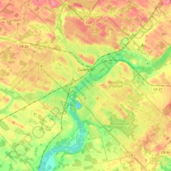
Name: Guelph topographic map, elevation, terrain.
Location: Guelph, Southwestern Ontario, Ontario, Canada (43.47381 -80.32691 43.59435 -80.15335)
Average elevation: 1,099 ft
Minimum elevation: 958 ft
Maximum elevation: 1,224 ft
Other topographic maps
Click on a map to view its topography, its elevation and its terrain.
Toronto
Despite its deep ravines, Toronto is not remarkably hilly, but its elevation does increase steadily away from the lake. Elevation differences range from 76.5 metres (251 ft) above sea level at the Lake Ontario shore to 209 m (686 ft) ASL near the York University grounds in the city's north end at the…
Average elevation: 371 ft
Fort Irwin Conservation Area Trail Head
Canada > Ontario > Haliburton County > Dysart et al
Average elevation: 1,283 ft
London
Canada > Ontario > London > London
London has a humid continental climate (Köppen Dfb), though due to its downwind location relative to Lake Huron and elevation changes across the city, it is virtually on the Dfa/Dfb (hot summer) boundary favouring the former climate zone to the southwest of the confluence of the South and North Thames Rivers,…
Average elevation: 879 ft
Guelph
This region of Ontario has cold winters and warm, humid summers, falling into the Köppen climate classification Dfb zone, with moderately high rainfall and snowfall. It is generally a couple of degrees cooler than lower elevation regions on the Great Lakes shorelines, especially so in winter, the exception…
Average elevation: 1,129 ft
Peterborough
Canada > Ontario > Peterborough
Peterborough's topography is largely defined by land formations created by the receding Wisconsian glaciers 10,000–15,000 years ago. The South End and Downtown portions of the City sit on what was the bottom of the glacial Lake Peterborough—part of a glacial spillway created when glacial meltwaters from…
Average elevation: 771 ft
Wainfleet Lake Erie Public Access Beach
Canada > Ontario > Niagara Region > Wainfleet
Average elevation: 574 ft
Aylen Lake
Canada > Ontario > Nipissing District > South Algonquin Township
Average elevation: 1,184 ft
Morrisburg
Canada > Ontario > Stormont, Dundas and Glengarry Counties > South Dundas
Average elevation: 259 ft
Batchawana Bay
Canada > Ontario > Algoma District > Unorganized North Algoma
Average elevation: 650 ft
Trent River
Canada > Ontario > Northumberland County > Trent Hills > Trent River
Average elevation: 646 ft
Madawaska River
Canada > Ontario > Renfrew County > Greater Madawaska > Calabogie
Average elevation: 525 ft
Little Crosby Lake
Canada > Ontario > Leeds and Grenville Counties > Rideau Lakes
Average elevation: 545 ft
Silent Lake Provincial Park
Canada > Ontario > Haliburton County > Highlands East
Average elevation: 1,217 ft
London
London has a humid continental climate (Köppen Dfb), though due to its downwind location relative to Lake Huron and elevation changes across the city, it is virtually on the Dfa/Dfb (hot summer) boundary favouring the former climate zone to the southwest of the confluence of the South and North Thames Rivers,…
Average elevation: 883 ft