
Cibola County topographic map
Interactive map
Click on the map to display elevation.
About this map
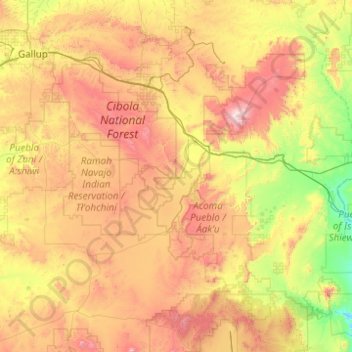
Name: Cibola County topographic map, elevation, terrain.
Location: Cibola County, New Mexico, United States (34.57779 -109.04611 35.34887 -107.06861)
Average elevation: 6,969 ft
Minimum elevation: 4,980 ft
Maximum elevation: 11,079 ft
New Mexico trails, hiking, mountain biking, running and outdoor activities
Other topographic maps
Click on a map to view its topography, its elevation and its terrain.
Albuquerque
United States > New Mexico > Bernalillo County > Albuquerque
Located in north-central New Mexico, Albuquerque serves as the county seat of Bernalillo County. To its east are the Sandia–Manzano Mountains, Rio Grande flows north to south through its center, while the West Mesa and Petroglyph National Monument make up the western part of the city. Albuquerque has one of…
Average elevation: 5,482 ft
Raton Pass
United States > New Mexico > Colfax County
Ratón Pass is a 7,834 ft (2,388 m) elevation mountain pass on the Colorado–New Mexico border in the western United States. It is located on the eastern side of the Sangre de Cristo Mountains between Trinidad, Colorado and Raton, New Mexico, approximately 180 miles (290 km) northeast of Santa Fe. Ratón is…
Average elevation: 7,867 ft
Standing Rock
United States > New Mexico > McKinley County > Standing Rock
Average elevation: 6,335 ft
Sunspot
United States > New Mexico > Otero County
Sunspot is an unincorporated community in the Sacramento Mountains in the Lincoln National Forest in Otero County, New Mexico, United States, about 18 miles (29 km) south of Cloudcroft. Its elevation is 9,186 feet (2,800 m). The Sunspot Solar Observatory and Apache Point Observatory are located in Sunspot in…
Average elevation: 8,615 ft
Embudo Canyon
United States > New Mexico > Bernalillo County > Albuquerque
Average elevation: 6,096 ft
La Luz
United States > New Mexico > Otero County > La Luz
The largest employer in the surrounding area is Holloman Air Force Base. La Luz itself is largely residential and agricultural in land use but a small market is located on the state maintained road that connects the village to Highway 70. La Luz has long been known for the many fruits that are grown in the…
Average elevation: 4,787 ft
Lake Farmington Recreation Area
United States > New Mexico > San Juan County > Farmington
Average elevation: 5,653 ft
Sandia Heights
United States > New Mexico > Bernalillo County > Albuquerque
Average elevation: 6,227 ft
Taos Ski Valley
United States > New Mexico > Taos County
Taos Ski Valley is a village and alpine ski resort in the southwestern United States, located in Taos County, New Mexico. The population was 69 at the 2010 census. Until March 19, 2008, it was one of four ski resorts in America to prohibit snowboarding. The Kachina lift, constructed in 2014, serves one of the…
Average elevation: 10,850 ft
Sipapu
United States > New Mexico > Taos County
Sipapu Ski & Summer Resort, also known simply as Sipapu, is a moderately sized ski resort in Taos County, New Mexico. It is home to New Mexico's longest ski season, from November to April. The peak elevation is 9,255 ft (2,821 m). There are 41 trails and 6 lifts. Other facilities include 4 terrain parks, golf,…
Average elevation: 9,035 ft
Las Cruces
United States > New Mexico > Doña Ana County > Las Cruces
The approximate elevation of Las Cruces is 3,908 feet (1,191 m) above sea level.
Average elevation: 4,314 ft
La Luz
United States > New Mexico > Otero County
The largest employer in the surrounding area is Holloman Air Force Base. La Luz itself is largely residential and agricultural in land use but a small market is located on the state maintained road that connects the village to Highway 70. La Luz has long been known for the many fruits that are grown in the…
Average elevation: 4,764 ft
Tres Piedras
United States > New Mexico > Taos County
Tres Piedras is located approximately 30 miles northwest of Taos, and west of the Rio Grande on U.S. Route 64. At approximately 8,000 feet (2,400 m) in altitude, it is located within the southern portion of the San Juan Range of the Rocky Mountains. Tres Piedras is on the western edge of a sagebrush plain,…
Average elevation: 8,123 ft