
Rockwall County topographic map
Interactive map
Click on the map to display elevation.
About this map
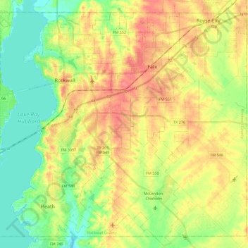
Name: Rockwall County topographic map, elevation, terrain.
Location: Rockwall County, Texas, United States (32.81391 -96.51896 32.98239 -96.29722)
Average elevation: 522 ft
Minimum elevation: 423 ft
Maximum elevation: 633 ft
Texas trails, hiking, mountain biking, running and outdoor activities
Other topographic maps
Click on a map to view its topography, its elevation and its terrain.
Georgetown
United States > Texas > Georgetown
The city is located on the northeastern edge of Texas Hill Country. Portions of Georgetown are located on either side of the Balcones Escarpment, a fault line in which the areas roughly east of IH-35 are flat and characterized by having black, fertile soils of the Blackland Prairie, and the west side of the…
Average elevation: 719 ft
Challenger 7 Memorial Park
United States > Texas > Harris County > League City
Average elevation: 20 ft
Sierra Blanca
United States > Texas > Hudspeth County
Sierra Blanca is found in Far West Texas, a subdivision of West Texas, and is 4,520 feet (1,380 m) above sea level. The town is part of the Trans-Pecos region within the most mountainous and arid portion of Texas. The town is located in Hudspeth County, which is large and sparsely populated. Sierra Blanca…
Average elevation: 4,564 ft
D'Hanis
United States > Texas > Medina County
D'Hanis is at an elevation of 883 feet (269 m) above sea level.
Average elevation: 896 ft
Rio Vista Addition Colonia
United States > Texas > El Paso County > Socorro
Average elevation: 3,661 ft
Clear Creek Natural Heritage Center
United States > Texas > Denton County > Denton
Average elevation: 568 ft
Matador Wildlife Management Area
United States > Texas > Cottle County > Paducah
Average elevation: 1,880 ft
Mineral Wells Fossil Park
United States > Texas > Palo Pinto County > Mineral Wells
Average elevation: 928 ft
Colonia del Rio Number 1
United States > Texas > El Paso County > San Elizario
Average elevation: 3,635 ft