
Make a donation
Gear up for your next adventure:
As an Amazon Associate, this site earns from qualifying purchases at no extra cost to you.
Gage County topographic map
Click on the map to display elevation.
Make a donation
Gear up for your next adventure:
As an Amazon Associate, this site earns from qualifying purchases at no extra cost to you.
About this map
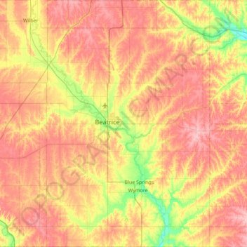
Name: Gage County topographic map, elevation, terrain.
Location: Gage County, Nebraska, United States (40.00084 -96.91695 40.52383 -96.46346)
Average elevation: 1,368 ft
Minimum elevation: 1,168 ft
Maximum elevation: 1,542 ft
Nebraska trails, hiking, mountain biking, running and outdoor activities
Make a donation
Gear up for your next adventure:
As an Amazon Associate, this site earns from qualifying purchases at no extra cost to you.
Other topographic maps
Click on a map to view its topography, its elevation and its terrain.
Make a donation
Gear up for your next adventure:
As an Amazon Associate, this site earns from qualifying purchases at no extra cost to you.
Westside Plaza Mobile Home Park
United States > Nebraska > Phelps County > Holdrege
Average elevation: 2,323 ft
Norfolk Mobile Home Community
United States > Nebraska > Madison County > Norfolk
Average elevation: 1,535 ft
Make a donation
Gear up for your next adventure:
As an Amazon Associate, this site earns from qualifying purchases at no extra cost to you.
Missouri River Basin Lewis & Clark Interpretive Trail & Visitors Center
United States > Nebraska > Otoe County
Average elevation: 1,010 ft
Make a donation
Gear up for your next adventure:
As an Amazon Associate, this site earns from qualifying purchases at no extra cost to you.
Old Fort Kearny Historical Marker
United States > Nebraska > Otoe County > Nebraska City
Average elevation: 981 ft
Make a donation
Gear up for your next adventure:
As an Amazon Associate, this site earns from qualifying purchases at no extra cost to you.
Make a donation
Gear up for your next adventure:
As an Amazon Associate, this site earns from qualifying purchases at no extra cost to you.
Kearney Cotton Mill Historical Marker
United States > Nebraska > Buffalo County > Cottonmill Mobile Home Court
Average elevation: 2,218 ft
Make a donation
Gear up for your next adventure:
As an Amazon Associate, this site earns from qualifying purchases at no extra cost to you.
Make a donation
Gear up for your next adventure:
As an Amazon Associate, this site earns from qualifying purchases at no extra cost to you.
Bloomfield Trailer Court
United States > Nebraska > Knox County > Bloomfield
Average elevation: 1,739 ft
Make a donation
Gear up for your next adventure:
As an Amazon Associate, this site earns from qualifying purchases at no extra cost to you.