
Pamlico County topographic map
Interactive map
Click on the map to display elevation.
Pamlico County
The county was formed in 1872 from parts of Beaufort and Craven counties. It was named for Pamlico Sound, which adjoins it. Vernacular usage in the area, especially in Craven County, refers to Pamlico County as being "down in the county." Prior to 1872, it was a part of Craven County and has a very low elevation. Most of the county, according to FRIS, North Carolina Flood Risk Information System, is subject to flooding in storm surges. After it was separated from Craven, the old nickname survives. Pamlico County remains rural in character and flavor, although the last decade has brought a good deal of residential development, largely the result of northern retirees and investors attracted to the many miles of waterfront property.
About this map
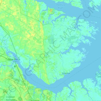
Name: Pamlico County topographic map, elevation, terrain.
Location: Pamlico County, North Carolina, United States (34.95030 -76.98758 35.36043 -76.30414)
Average elevation: 16 ft
Minimum elevation: -36 ft
Maximum elevation: 128 ft
North Carolina trails, hiking, mountain biking, running and outdoor activities
Other topographic maps
Click on a map to view its topography, its elevation and its terrain.
Arden
United States > North Carolina > Buncombe County > Asheville > Royal Pines
Average elevation: 2,274 ft
Murphy
United States > North Carolina > Cherokee County > Murphy
Murphy is located in southwestern North Carolina, approximately halfway between Atlanta, Georgia and Knoxville, Tennessee. The topography sonsists of gentle rolling hills and mountains with tall peaks, including ranges from 1800 ft to more than 5000 ft elevation. The location in the Blue Ridge Mountains has…
Average elevation: 1,732 ft
North Toe River
United States > North Carolina > Mitchell County > Spruce Pine
Average elevation: 2,703 ft
Idlewild Farms
United States > North Carolina > Mecklenburg County > Charlotte
Average elevation: 728 ft
Kanuga Lake
United States > North Carolina > Henderson County > Kanuga Ridge
Average elevation: 2,356 ft
Echo Lake
United States > North Carolina > Henderson County > Laurel Park > Country Ridge
Average elevation: 2,493 ft
Patton Park
United States > North Carolina > Henderson County > Hendersonville
Average elevation: 2,149 ft
Country Club North
United States > North Carolina > Cumberland County > Fayetteville
Average elevation: 203 ft
Lake Johnson
United States > North Carolina > Wake County > Raleigh > Orchards
Average elevation: 397 ft
North Carolina Coastal Land Trust: Orton Plantation Holdings, LLC
United States > North Carolina > Brunswick County
Average elevation: 26 ft
Shearon Harris Auxiliary Reservoir Dam
United States > North Carolina > Wake County
Average elevation: 259 ft
Willow Wew
United States > North Carolina > Henderson County > Hendersonville
Average elevation: 2,188 ft
Carolina Industrial Park
United States > North Carolina > Gaston County > Cherryville
Average elevation: 909 ft
Flat Rock Forest
United States > North Carolina > Henderson County > Flat Rock
Average elevation: 2,234 ft
George Washington Carver
United States > North Carolina > Lenoir County > Kinston
Average elevation: 46 ft