
Warren County topographic map
Interactive map
Click on the map to display elevation.
Warren County
Warren County is situated in the eastern portion of New York State in the Adirondack Mountains. The eastern border is Washington County. The highest peak in the county is Gore Mountain at an elevation of 3,198 feet (975 m). It is typically included as the northern part of the Capital District although it is sometimes included as part of the North Country.
About this map
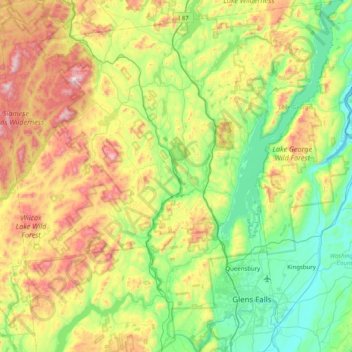
Name: Warren County topographic map, elevation, terrain.
Location: Warren County, New York, United States (43.22224 -74.21443 43.80370 -73.43657)
Average elevation: 1,168 ft
Minimum elevation: 82 ft
Maximum elevation: 3,537 ft
New York trails, hiking, mountain biking, running and outdoor activities
Other topographic maps
Click on a map to view its topography, its elevation and its terrain.
Central Park
United States > New York > New York County > New York
In June 1856, Fernando Wood appointed a "consulting board" of seven people, headed by author Washington Irving, to inspire public confidence in the proposed development. Wood hired military engineer Egbert Ludovicus Viele as the park's chief engineer, tasking him with a topographical survey of the site. The…
Average elevation: 85 ft
Cedar Knolls
United States > New York > Westchester County > City of Yonkers
Average elevation: 187 ft
Tug Hill
United States > New York > Oswego County
The core Tug Hill region encompasses 150,000 acres (610 km2) of unbroken, generally second-growth, northern hardwood forest, and is drained by a vast network of streams. Important rivers and streams whose headwaters are located within the Tug Hill region include the Mohawk River, Deer River, Salmon River, Mad…
Average elevation: 358 ft
Catskills Visitor Center
United States > New York > Ulster County > Town of Shandaken > Beechford
Average elevation: 988 ft
Central Park
United States > New York > New York County > New York
In June 1856, Fernando Wood appointed a "consulting board" of seven people, headed by author Washington Irving, to inspire public confidence in the proposed development. Wood hired military engineer Egbert Ludovicus Viele as the park's chief engineer, tasking him with a topographical survey of the site. The…
Average elevation: 85 ft
Roberto Clemente State Park
United States > New York > Bronx County > New York
Average elevation: 105 ft
Barberville
United States > New York > Rensselaer County > Town of Poestenkill
Average elevation: 883 ft
Fisherman's Landing
United States > New York > Erie County > Town of Grand Island > Grandyle Village
Average elevation: 587 ft
West Canada Creek
United States > New York > Oneida County > Town of Trenton
Average elevation: 794 ft
Ellicottville
United States > New York > Cattaraugus County > Village of Ellicottville
Average elevation: 1,880 ft
Benjamin's Memorial Beach
United States > New York > Suffolk County > Bay Shore
Average elevation: 7 ft
Vails Gate Junction
United States > New York > Orange County > Town of New Windsor > Vails Gate
Average elevation: 302 ft
Whitehall Corners
United States > New York > Westchester County > Town of Somers
Average elevation: 318 ft
Benjamin's Memorial Beach
United States > New York > Suffolk County > Bay Shore
Average elevation: 7 ft
Chestnut Ridge Park
United States > New York > Erie County > Town of Orchard Park
Average elevation: 1,030 ft
Beechmont
United States > New York > Westchester County > City of New Rochelle
Average elevation: 102 ft
Niagara Escarpment
United States > New York > Niagara County > City of Lockport
Average elevation: 489 ft
Trumbull Corners
United States > New York > Tompkins County > Town of Newfield
Average elevation: 1,453 ft
West Saint Johnsville
United States > New York > Montgomery County > Town of Saint Johnsville
Average elevation: 495 ft
Whitehall Corners
United States > New York > Westchester County > Town of Somers
Average elevation: 318 ft
Lake Tonetta
United States > New York > Putnam County > Brewster > Brewster Hill
Average elevation: 509 ft
Broome Center
United States > New York > Schoharie County > Town of Gilboa
Average elevation: 2,051 ft
Apaquogue
United States > New York > Suffolk County > Village of East Hampton
Average elevation: 16 ft
Sunset Ridge
United States > New York > Westchester County > Town/Village of Harrison
Average elevation: 89 ft
Orchard Knoll
United States > New York > Chemung County > Town of Horseheads
Average elevation: 1,102 ft
Eastport South Manor Athletic Complex
United States > New York > Suffolk County > Town of Brookhaven > Eastport
Average elevation: 49 ft
Broome Center
United States > New York > Schoharie County > Town of Gilboa
Average elevation: 2,051 ft
Lee Town Park
United States > New York > Oneida County > Lake Delta > Town of Lee
Average elevation: 604 ft
Heath Ridge
United States > New York > Westchester County > Village of Scarsdale
Average elevation: 217 ft
Barnum Corners
United States > New York > Putnam County > Town of Patterson > Putnam Lake
Average elevation: 571 ft