
Make a donation
Gear up for your next adventure:
As an Amazon Associate, this site earns from qualifying purchases at no extra cost to you.
Chester County topographic map
Click on the map to display elevation.
Make a donation
Gear up for your next adventure:
As an Amazon Associate, this site earns from qualifying purchases at no extra cost to you.
Chester County
Chester County lies within southeastern Pennsylvania’s Piedmont landscape, where the terrain is shaped by a sequence of rolling uplands, elongated ridges, and stream-cut valleys rather than by broad plains or high mountains. Its relief is especially varied across the northern and western parts of the county, where resistant metamorphic rocks form rounded hills and ridge belts such as Mine Ridge and the uplands around French Creek, while lower, more open corridors such as Chester Valley follow softer geologic zones. Elevations generally descend from the higher Piedmont uplands in the northwest and west toward the gentler lowlands and river-drained areas to the east and southeast, where streams such as the Brandywine, French, White Clay, Red Clay, Valley, and Schuylkill tributaries carve shallow to moderately incised valleys. Overall, the county presents a classic Piedmont topography: undulating agricultural and wooded hills, narrow valley floors, locally steep stream slopes, and a gradual transition toward the lower Delaware River basin and the Philadelphia-area lowlands.
Make a donation
Gear up for your next adventure:
As an Amazon Associate, this site earns from qualifying purchases at no extra cost to you.
About this map
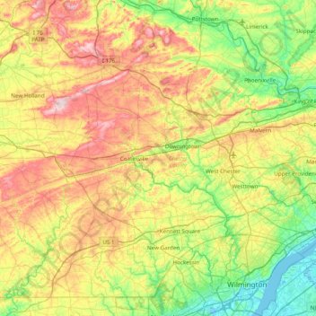
Name: Chester County topographic map, elevation, terrain.
Location: Chester County, Pennsylvania, United States (39.72149 -76.13658 40.24509 -75.36105)
Average elevation: 407 ft
Minimum elevation: -16 ft
Maximum elevation: 1,102 ft
Pennsylvania trails, hiking, mountain biking, running and outdoor activities
Make a donation
Gear up for your next adventure:
As an Amazon Associate, this site earns from qualifying purchases at no extra cost to you.
Other topographic maps
Click on a map to view its topography, its elevation and its terrain.
Blue Mountain
United States > Pennsylvania > Dauphin County > Middle Paxton Township
The ridge of Blue Mountain runs for 150 miles (240 km) through Pennsylvania, reaching an elevation of 2,270 feet (690 m) above sea level just north of the Pennsylvania Turnpike, near the borough of Newburg. Most of the ridgecrest, however, only reaches between 1,400 and 1,700 feet (430 and 520 m) in elevation.…
Average elevation: 653 ft
Make a donation
Gear up for your next adventure:
As an Amazon Associate, this site earns from qualifying purchases at no extra cost to you.
Dingmans Ferry
United States > Pennsylvania > Pike County > Delaware Township
Average elevation: 630 ft
Havertown
United States > Pennsylvania > Delaware County > Haverford Township
Average elevation: 276 ft
Valley Forge
United States > Pennsylvania > Chester County > Schuylkill Township
Average elevation: 256 ft
Make a donation
Gear up for your next adventure:
As an Amazon Associate, this site earns from qualifying purchases at no extra cost to you.
Fern Glen
United States > Pennsylvania > Luzerne County > Black Creek Township
Average elevation: 1,283 ft
Albrightsville
United States > Pennsylvania > Carbon County > Kidder Township
Average elevation: 1,634 ft
East Texas
United States > Pennsylvania > Lehigh County > Lower Macungie Township
Average elevation: 413 ft
Lords Valley
United States > Pennsylvania > Pike County > Blooming Grove Township
Average elevation: 1,352 ft
Make a donation
Gear up for your next adventure:
As an Amazon Associate, this site earns from qualifying purchases at no extra cost to you.
Enfield
United States > Pennsylvania > Montgomery County > Springfield Township > Wyndmoor
Average elevation: 285 ft
Idaho
United States > Pennsylvania > Armstrong County > South Bend Township
Average elevation: 1,112 ft
Penfield
United States > Pennsylvania > Clearfield County > Huston Township
Average elevation: 1,437 ft
Make a donation
Gear up for your next adventure:
As an Amazon Associate, this site earns from qualifying purchases at no extra cost to you.
Mainesburg
United States > Pennsylvania > Tioga County > Sullivan Township
Average elevation: 1,565 ft
Mount Nebo Park
United States > Pennsylvania > Monroe County > East Stroudsburg > Twin Falls
Average elevation: 607 ft
Make a donation
Gear up for your next adventure:
As an Amazon Associate, this site earns from qualifying purchases at no extra cost to you.
Cowden
United States > Pennsylvania > Washington County > Cecil Township > Cecil
Average elevation: 1,135 ft
Keown Station
United States > Pennsylvania > Allegheny County > Ross Township
Average elevation: 1,129 ft
Make a donation
Gear up for your next adventure:
As an Amazon Associate, this site earns from qualifying purchases at no extra cost to you.
Glenshaw
United States > Pennsylvania > Allegheny County > Shaler Township
Average elevation: 1,024 ft
Make a donation
Gear up for your next adventure:
As an Amazon Associate, this site earns from qualifying purchases at no extra cost to you.
Make a donation
Gear up for your next adventure:
As an Amazon Associate, this site earns from qualifying purchases at no extra cost to you.
New Enterprise
United States > Pennsylvania > Bedford County > South Woodbury Township
Average elevation: 1,302 ft
Blue Knob
United States > Pennsylvania > Bedford County > Pavia Township
Blue Knob (elevation 3,146 feet (959 m)) is a summit in the eastern United States with a broad dome that is the northernmost 3,000-footer in the Allegheny Mountains. It is the highest point in Bedford County, Pennsylvania.
Average elevation: 2,598 ft
Sinnemahoning
United States > Pennsylvania > Cameron County > Gibson Township
Average elevation: 1,332 ft
Make a donation
Gear up for your next adventure:
As an Amazon Associate, this site earns from qualifying purchases at no extra cost to you.
Saint Benedict
United States > Pennsylvania > Cambria County > West Carroll Township
Average elevation: 1,909 ft
English Center
United States > Pennsylvania > Lycoming County > Pine Township
Average elevation: 1,457 ft
Tyrrel Farm Corners
United States > Pennsylvania > Venango County > Allegheny Township
Average elevation: 1,568 ft
Make a donation
Gear up for your next adventure:
As an Amazon Associate, this site earns from qualifying purchases at no extra cost to you.
Fort Hunter
United States > Pennsylvania > Dauphin County > Middle Paxton Township
Average elevation: 489 ft
Spring Run
United States > Pennsylvania > Franklin County > Fannett Township
Average elevation: 955 ft
Green Village
United States > Pennsylvania > Franklin County > Greene Township
Average elevation: 679 ft
Make a donation
Gear up for your next adventure:
As an Amazon Associate, this site earns from qualifying purchases at no extra cost to you.
Normalville
United States > Pennsylvania > Fayette County > Springfield Township
Average elevation: 1,594 ft
Chalkhill
United States > Pennsylvania > Fayette County > Wharton Township
Average elevation: 2,044 ft
Arnold City
United States > Pennsylvania > Fayette County > Washington Township
Average elevation: 994 ft
Three Tuns
United States > Pennsylvania > Montgomery County > Upper Dublin Township > Maple Glen
Average elevation: 331 ft
Make a donation
Gear up for your next adventure:
As an Amazon Associate, this site earns from qualifying purchases at no extra cost to you.
Hidden Valley
United States > Pennsylvania > Montgomery County > Upper Merion Township
Average elevation: 154 ft
Newfoundland
United States > Pennsylvania > Wayne County > Dreher Township
Average elevation: 1,496 ft
Strafford
United States > Pennsylvania > Chester County > Tredyffrin Township
Average elevation: 436 ft
Make a donation
Gear up for your next adventure:
As an Amazon Associate, this site earns from qualifying purchases at no extra cost to you.
West Pittsburg
United States > Pennsylvania > Lawrence County > Taylor Township
Average elevation: 915 ft
Robinson
United States > Pennsylvania > Indiana County > West Wheatfield Township
Average elevation: 1,302 ft
Make a donation
Gear up for your next adventure:
As an Amazon Associate, this site earns from qualifying purchases at no extra cost to you.
Hazelton Mills
United States > Pennsylvania > McKean County > Bradford Township
Average elevation: 1,962 ft
Fogelsville
United States > Pennsylvania > Lehigh County > Upper Macungie Township
Average elevation: 509 ft
Tobyhanna
United States > Pennsylvania > Monroe County > Coolbaugh Township
Average elevation: 1,936 ft
Bear Rocks
United States > Pennsylvania > Fayette County > Bullskin Township
Average elevation: 1,873 ft
Make a donation
Gear up for your next adventure:
As an Amazon Associate, this site earns from qualifying purchases at no extra cost to you.
Barnesville
United States > Pennsylvania > Schuylkill County > Rush Township
Average elevation: 1,175 ft
Mount Bethel
United States > Pennsylvania > Northampton County > Upper Mount Bethel Township
Average elevation: 512 ft
Rosemount
United States > Pennsylvania > York County > Spring Garden Township
Average elevation: 548 ft
Make a donation
Gear up for your next adventure:
As an Amazon Associate, this site earns from qualifying purchases at no extra cost to you.
Ruthfred Acres
United States > Pennsylvania > Allegheny County > Bethel Park
Average elevation: 1,142 ft
Reservoir Heights
United States > Pennsylvania > Dauphin County > Upper Paxton Township
Average elevation: 620 ft
Skytop
United States > Pennsylvania > Monroe County > Barrett Township
Skytop is an unincorporated community in Barrett Township, Monroe County, Pennsylvania, United States. Located north of Mountainhome, it is accessible by local roads off Route 390. Its elevation is 1,562 feet (476 m), and it is located at 41°13′40″N 75°14′18″W / 41.22778°N 75.23833°W /…
Average elevation: 1,539 ft
Ricketts Glen State Park
United States > Pennsylvania > Luzerne County > Fairmount Township
The state's original plans for the new park included building an inn, an 18-hole golf course and country club, and a winter sports complex for skiing, ice boating, and tobogganing, as well as a beach with bathing facilities, cabins, and a tent camping area. Only the last three were actually built, all south of…
Average elevation: 1,929 ft
Make a donation
Gear up for your next adventure:
As an Amazon Associate, this site earns from qualifying purchases at no extra cost to you.
Mount Cobb
United States > Pennsylvania > Lackawanna County > Jefferson Township
Average elevation: 1,736 ft
Pipersville
United States > Pennsylvania > Bucks County > Bedminster Township
Average elevation: 410 ft
Make a donation
Gear up for your next adventure:
As an Amazon Associate, this site earns from qualifying purchases at no extra cost to you.
Pastorius Park
United States > Pennsylvania > Philadelphia County > Philadelphia
Average elevation: 354 ft
Danielsville
United States > Pennsylvania > Northampton County > Lehigh Township
Average elevation: 833 ft
Make a donation
Gear up for your next adventure:
As an Amazon Associate, this site earns from qualifying purchases at no extra cost to you.
Blue Mountain
United States > Pennsylvania > Monroe County > Eldred Township
The ridge of Blue Mountain runs for 150 miles (240 km) through Pennsylvania, reaching an elevation of 2,270 feet (690 m) above sea level just north of the Pennsylvania Turnpike, near the borough of Newburg. Most of the ridgecrest, however, only reaches between 1,400 and 1,700 feet (430 and 520 m) in elevation.…
Average elevation: 794 ft
Park Place
United States > Pennsylvania > Schuylkill County > Mahanoy Township
Average elevation: 1,690 ft
Portlamd Waterfront Park
United States > Pennsylvania > Northampton County > Portland
Average elevation: 387 ft
Make a donation
Gear up for your next adventure:
As an Amazon Associate, this site earns from qualifying purchases at no extra cost to you.
Atlasburg
United States > Pennsylvania > Washington County > Smith Township
Average elevation: 1,165 ft
Horningford
United States > Pennsylvania > Mifflin County > Bratton Township
Average elevation: 663 ft
Stevens Point
United States > Pennsylvania > Susquehanna County > Harmony Township
Average elevation: 1,424 ft
Pendle Hill
United States > Pennsylvania > Delaware County > Nether Providence Township
Average elevation: 200 ft
Make a donation
Gear up for your next adventure:
As an Amazon Associate, this site earns from qualifying purchases at no extra cost to you.
Longwood Gardens
United States > Pennsylvania > Chester County > East Marlborough Township
Average elevation: 410 ft
Nottingham County Park
United States > Pennsylvania > Chester County > West Nottingham Township
Average elevation: 449 ft
Make a donation
Gear up for your next adventure:
As an Amazon Associate, this site earns from qualifying purchases at no extra cost to you.
Marble Hall
United States > Pennsylvania > Montgomery County > Whitemarsh Township
Average elevation: 210 ft
Circleville
United States > Pennsylvania > Westmoreland County > North Huntingdon Township
Average elevation: 1,093 ft
Make a donation
Gear up for your next adventure:
As an Amazon Associate, this site earns from qualifying purchases at no extra cost to you.
Chadds Ford Township
United States > Pennsylvania > Delaware County > Chadds Ford Township
Average elevation: 331 ft
Strawberry Mansion
United States > Pennsylvania > Philadelphia County > Philadelphia
Average elevation: 102 ft
Make a donation
Gear up for your next adventure:
As an Amazon Associate, this site earns from qualifying purchases at no extra cost to you.
Reinholds
United States > Pennsylvania > Lancaster County > West Cocalico Township
Average elevation: 522 ft
Langhorne Gardens
United States > Pennsylvania > Bucks County > Middletown Township
Average elevation: 148 ft
Monroe Heights
United States > Pennsylvania > Allegheny County > Monroeville
Average elevation: 1,083 ft
Make a donation
Gear up for your next adventure:
As an Amazon Associate, this site earns from qualifying purchases at no extra cost to you.