Geolocate

Rabun County topographic map

Interactive map

Click on the map to display elevation.

About this map

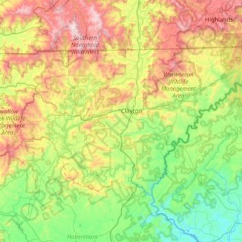
Name: Rabun County topographic map, elevation, terrain.

Location: Rabun County, Georgia, United States (34.71594 -83.66164 35.00068 -83.09834)

Average elevation: 2,254 ft

Minimum elevation: 650 ft

Maximum elevation: 5,413 ft

The Eastern Continental Divide runs through the county, roughly from southwest to northeast, also representing a portion of the Tennessee Valley Divide. The county's eastern border with South Carolina is formed by the Chattooga River, the largest tributary of the Tugaloo River and then Savannah River (which forms the rest of the border of the two states). The north-central portion of Rabun County is in the watershed of the Little Tennessee River, which flows northward from Mountain City. The high elevation along the divide gives Rabun County the most snow of any in county in Georgia. This also gives it mild weather throughout the warmer months of the year, leading to the county's slogan, Where Spring Spends the Summer. Rabun County is the only county in Georgia with three state parks: Black Rock Mountain, Moccasin Creek, and Tallulah Gorge.

Wikipedia (CC-BY-SA 3.0)

Other topographic maps

Click on a map to view its topography, its elevation and its terrain.

Atlanta

United States > Georgia > Fulton County

Atlanta, Fulton County, Georgia, United States

Average elevation: 932 ft

Savannah

United States > Georgia > Chatham County

Savannah, Chatham County, Georgia, United States

Average elevation: 13 ft

Blue Ridge

United States > Georgia > Fannin County

Blue Ridge, Fannin County, Georgia, United States

Average elevation: 1,755 ft

Augusta

United States > Georgia > Augusta

Augusta, Richmond County, Georgia, 30901, United States

Average elevation: 295 ft

Carroll County

United States > Georgia

Carroll County, Georgia, United States

Average elevation: 1,066 ft

Athens

United States > Georgia > Athens

Athens, Athens-Clarke County, Georgia, 303341458, United States

Average elevation: 725 ft

Helen

United States > Georgia > White County

Helen, White County, Georgia, 30545, United States

Average elevation: 1,601 ft

Atlanta

United States > Georgia > Fulton County

Atlanta, Fulton County, Georgia, 30303, United States

Average elevation: 935 ft

Ellijay

United States > Georgia > Gilmer County

Ellijay, Gilmer County, Georgia, 30540, United States

Average elevation: 1,391 ft

Tybee Island

United States > Georgia > Chatham County

Tybee Island, Chatham County, Georgia, 31328, United States

Average elevation: 3 ft

Camden County

United States > Georgia

Camden County, Georgia, United States

Average elevation: 13 ft

Gwinnett County

United States > Georgia

Gwinnett County, Georgia, United States

Average elevation: 991 ft

Dahlonega

United States > Georgia > Lumpkin County

Dahlonega, Lumpkin County, Georgia, United States

Average elevation: 1,348 ft

Brunswick

United States > Georgia > Glynn County

Brunswick, Glynn County, Georgia, United States

Average elevation: 7 ft

Georgia International Horse Park

United States > Georgia > Rockdale County > Conyers

Georgia International Horse Park, Conyers, Rockdale County, Georgia, United States

Average elevation: 686 ft

Alpharetta

United States > Georgia > Fulton County

Alpharetta, Fulton County, Georgia, United States

Average elevation: 1,063 ft

Saint Simons Island

United States > Georgia > Glynn County

Saint Simons Island, Glynn County, Georgia, 31561, United States

Average elevation: 7 ft

Macon

United States > Georgia > Bibb County

Macon, Bibb County, Georgia, United States

Average elevation: 417 ft

Columbus

United States > Georgia > Muscogee County

Columbus, Muscogee County, Georgia, United States

Average elevation: 427 ft

Vinings

United States > Georgia > Cobb County

Vinings, Cobb County, Georgia, 30339, United States

Average elevation: 922 ft

Union County

United States > Georgia

Union County, Georgia, United States

Average elevation: 2,349 ft

Hiawassee

United States > Georgia > Towns County

Hiawassee, Towns County, Georgia, United States

Average elevation: 2,034 ft

Gainesville

United States > Georgia > Hall County

Gainesville, Hall County, Georgia, 30501, United States

Average elevation: 1,135 ft

Blairsville

United States > Georgia > Union County

Blairsville, Union County, Georgia, United States

Average elevation: 1,926 ft

Cobb County

United States > Georgia

Cobb County, Georgia, United States

Average elevation: 988 ft

Skidaway Island

United States > Georgia > Chatham County

Skidaway Island, Chatham County, Georgia, 31411, United States

Average elevation: 10 ft

Floyd County

United States > Georgia

Floyd County, Georgia, United States

Average elevation: 781 ft

Fannin County

United States > Georgia

Fannin County, Georgia, United States

Average elevation: 2,060 ft

Lumpkin

United States > Georgia > Stewart County

Lumpkin, Stewart County, Georgia, United States

Average elevation: 482 ft

Alapaha River

United States > Georgia

Alapaha River, Georgia, United States

Average elevation: 213 ft

DeKalb County

United States > Georgia

DeKalb County, Georgia, United States

Average elevation: 932 ft

Canton

United States > Georgia > Cherokee County

Canton, Cherokee County, Georgia, United States

Average elevation: 1,050 ft

Jointer Island

United States > Georgia > Glynn County > Brunswick

Jointer Island, Brunswick, Glynn County, Georgia, United States

Average elevation: 0 ft

Forsyth County

United States > Georgia

Forsyth County, Georgia, United States

Average elevation: 1,129 ft

Heritage Acres

United States > Georgia > Bibb County > Macon

Heritage Acres, Macon, Bibb County, Georgia, 31211, United States

Average elevation: 390 ft

Robins Air Force Base

United States > Georgia > Houston County

Robins Air Force Base, Houston County, Georgia, 31098, United States

Average elevation: 302 ft

Stone Mountain

United States > Georgia > DeKalb County

Stone Mountain, DeKalb County, Georgia, 30087, United States

Average elevation: 981 ft

Woodstock

United States > Georgia > Cherokee County

Woodstock, Cherokee County, Georgia, United States

Average elevation: 971 ft

Lake Oconee

United States > Georgia > Greene County > Lake Oconee

Lake Oconee, Greene County, Georgia, United States

Average elevation: 541 ft

Mountain City

United States > Georgia > Rabun County

Mountain City, Rabun County, Georgia, 30562, United States

Average elevation: 2,451 ft

Kennesaw

United States > Georgia > Cobb County

Kennesaw, Cobb County, Georgia, 30144, United States

Average elevation: 1,040 ft

Iron Mountain

United States > Georgia > Murray County

Iron Mountain, Murray County, Georgia, United States

Average elevation: 1,188 ft

Fort Pulaski

United States > Georgia > Chatham County

Fort Pulaski, Fort Perimeter Trail, Chatham County, Georgia, 31328, United States

Average elevation: 3 ft

Tugaloo

United States > Georgia > Habersham County > Tallulah Falls

Tugaloo, Tallulah Falls, Habersham County, Georgia, United States

Average elevation: 1,286 ft

Elmodel

United States > Georgia > Baker County

Elmodel, Baker County, Georgia, United States

Average elevation: 167 ft

Leary

United States > Georgia > Calhoun County

Leary, Calhoun County, Georgia, 39862, United States

Average elevation: 200 ft

Paulding County

United States > Georgia

Paulding County, Georgia, United States

Average elevation: 1,020 ft

Warner Robins

United States > Georgia > Houston County

Warner Robins, Houston County, Georgia, United States

Average elevation: 331 ft

Fargo

United States > Georgia > Clinch County

Fargo, Clinch County, Georgia, United States

Average elevation: 112 ft

Worley Crossroads

United States > Georgia > Cherokee County

Worley Crossroads, Cherokee County, Georgia, United States

Average elevation: 1,240 ft