
Davidson County topographic map
Interactive map
Click on the map to display elevation.
About this map
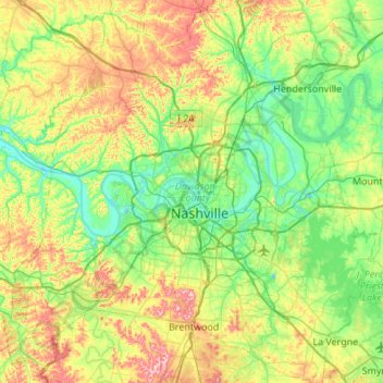
Name: Davidson County topographic map, elevation, terrain.
Location: Davidson County, Middle Tennessee, Tennessee, United States (35.96779 -87.05477 36.40550 -86.51559)
Average elevation: 607 ft
Minimum elevation: 374 ft
Maximum elevation: 1,122 ft
Tennessee trails, hiking, mountain biking, running and outdoor activities
Other topographic maps
Click on a map to view its topography, its elevation and its terrain.
Pinson Mounds State Archaeological Area
United States > Tennessee > Madison County
Average elevation: 394 ft
Millersville City Park
United States > Tennessee > Robertson County > Millersville
Average elevation: 853 ft
Big Fiery Gizzard Creek
United States > Tennessee > Marion County > Kimball
Average elevation: 1,204 ft
Brainerd
United States > Tennessee > Hamilton County > Chattanooga > Ridgeside
Average elevation: 768 ft
Cherokee Dam - Saddle Dam No. 1
United States > Tennessee > Jefferson County
Average elevation: 1,053 ft
Douglas Dam
United States > Tennessee > Sevier County > Sevierville
The Douglas Project required the construction of ten smaller, earthen saddle dams to fill in gaps along the adjacent ridgeline and permit a higher water elevation than would otherwise be possible. Most of these saddle dams are located in the hills southeast of the main dam. One protects downtown Dandridge,…
Average elevation: 1,024 ft
Edwin Warner Park
United States > Tennessee > Davidson County > Nashville > Devonshire Manor
Average elevation: 650 ft
Evergreen Estates
United States > Tennessee > Montgomery County > Clarksville
Average elevation: 482 ft
Loafer's Corner
United States > Tennessee > Rutherford County > Smyrna > Smyrna
Average elevation: 600 ft
Stonehenge Estates
United States > Tennessee > Williamson County > Brentwood
Average elevation: 840 ft
Barfield Crescent Park
United States > Tennessee > Rutherford County > Murfreesboro
Average elevation: 659 ft
Northcreek Commons
United States > Tennessee > Davidson County > Goodlettsville
Average elevation: 509 ft