
Make a donation
Gear up for your next adventure:
As an Amazon Associate, this site earns from qualifying purchases at no extra cost to you.
Uinta Mountains topographic map
Click on the map to display elevation.
Make a donation
Gear up for your next adventure:
As an Amazon Associate, this site earns from qualifying purchases at no extra cost to you.
Uinta Mountains
The high Uintas were extensively glaciated during the last ice age, and most of the large stream valleys on both the north and south sides of the range held long valley glaciers. However, despite reaching to over 13,500 feet (4,110 m) in elevation, the climate today is sufficiently dry that no glaciers survived even before the rapid current glacial retreat began in the middle nineteenth century. The Uintas are the most poleward mountain range in the world to reach over 13,000 feet (4,000 m) without modern glaciers, and are in fact the highest mountain range in the contiguous United States with no modern glaciers. Permafrost occurs at elevations above 10,000 feet (3,000 m) and at times forms large rock glaciers.
Make a donation
Gear up for your next adventure:
As an Amazon Associate, this site earns from qualifying purchases at no extra cost to you.
About this map
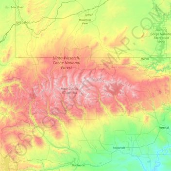
Name: Uinta Mountains topographic map, elevation, terrain.
Location: Uinta Mountains, Utah, United States (40.47516 -111.19949 41.08660 -109.45679)
Average elevation: 7,753 ft
Minimum elevation: 4,659 ft
Maximum elevation: 13,445 ft
Utah trails, hiking, mountain biking, running and outdoor activities
Make a donation
Gear up for your next adventure:
As an Amazon Associate, this site earns from qualifying purchases at no extra cost to you.
Other topographic maps
Click on a map to view its topography, its elevation and its terrain.
Salt Lake City
United States > Utah > Salt Lake County
Salt Lake City's topography is characterized by a striking contrast between its flat valley floor and the surrounding rugged mountains. The city is situated in the Salt Lake Valley, with an average elevation of approximately 4,237 feet above sea level, making it one of the higher major cities in the United…
Average elevation: 5,223 ft
Provo
United States > Utah > Utah County
Provo lies in the Utah Valley at an elevation of 4,549 feet (1,387 m). According to the United States Census Bureau, the city has an area of 44.2 square miles (114.4 km2), of which 41.7 square miles (107.9 km2) is land and 2.5 square miles (6.5 km2), or 5.66%, is water.
Average elevation: 5,669 ft
Wasatch Range
The range's highest point — 11,928 feet (3,636 m) — is Mount Nebo, a triple peak rising above Nephi, at the southern end of the range. In some places the mountains rise steeply from the valley's base elevation of 4,330 feet (1,320 m) to over 11,000 feet (3,400 m). Other notable peaks include Mount…
Average elevation: 6,175 ft
Park City
United States > Utah > Summit County
In the summertime, many valley residents of the Wasatch Front visit the town to escape high temperatures. Park City is usually cooler than Salt Lake City as it lies mostly higher than 7,000 feet (2,100 m) above sea level, while Salt Lake City is situated at an elevation of about 4,300 feet (1,300 m).
Average elevation: 7,513 ft
Make a donation
Gear up for your next adventure:
As an Amazon Associate, this site earns from qualifying purchases at no extra cost to you.
Park City
United States > Utah > Summit County
In the summertime, many valley residents of the Wasatch Front visit the town to escape high temperatures. Park City is usually cooler than Salt Lake City as it lies mostly higher than 7,000 feet (2,100 m) above sea level, while Salt Lake City is situated at an elevation of about 4,300 feet (1,300 m).
Average elevation: 7,513 ft
Saint George
United States > Utah > Washington County
The St. George valley occasionally receives wet or slushy snowfall in the winter, but what accumulates usually melts off by the mid-to-late morning; the normal seasonal snowfall is 1.4 inches (3.6 cm). The earliest snowfall was measured on October 29, 1971, and the latest on April 11, 1927. The record…
Average elevation: 3,048 ft
Zion National Park
United States > Utah > Washington County
The 8,726-foot (2,660 m) summit of Horse Ranch Mountain is the highest point in the park; the lowest point is the 3,666-foot (1,117 m) elevation of Coal Pits Wash, creating a relief of about 5,100 feet (1,600 m).
Average elevation: 6,158 ft
Make a donation
Gear up for your next adventure:
As an Amazon Associate, this site earns from qualifying purchases at no extra cost to you.
Logan
United States > Utah > Cache County
The city lies near the eastern edge of Cache Valley on the western slopes of the Bear River Mountains. Mount Logan rises to an elevation of 9,710 feet (2,960 m) immediately to the east, and south of Logan Canyon. The eastern portions of the city are constructed on top of shelf-like "benches", late Pleistocene…
Average elevation: 4,915 ft
Cedar City
United States > Utah > Iron County
Cedar City is located in the southeast Great Basin and is approximately 20 miles (32 km) north of the northeastern edge of the Mojave Desert. Its elevation of 5,846 feet (1,782 m) gives it a somewhat cooler climate compared to the nearby St. George region, though it retains cultural ties to the city —for…
Average elevation: 6,480 ft
St. George
United States > Utah > Washington County
The St. George valley occasionally receives wet or slushy snowfall in the winter, but what accumulates usually melts off by the mid-to-late morning; the normal seasonal snowfall is 1.4 inches (3.6 cm). The earliest snowfall was measured on October 29, 1971, and the latest on April 11, 1927. The record…
Average elevation: 3,064 ft
Make a donation
Gear up for your next adventure:
As an Amazon Associate, this site earns from qualifying purchases at no extra cost to you.
Moab
United States > Utah > Grand County
Moab is just south of the Colorado River, at an elevation of 4,025 feet (1,227 m) on the Colorado Plateau. It is 18 miles (29 km) west of the Utah/Colorado state line. Via U.S. Route 191, it is 31 miles (50 km) south of Interstate 70 at Crescent Junction, and it is 54 miles (87 km) north of Monticello. Via…
Average elevation: 4,452 ft
Park City
United States > Utah > Summit County
In the summertime, many valley residents of the Wasatch Front visit the town to escape high temperatures. Park City is usually cooler than Salt Lake City as it lies mostly higher than 7,000 feet (2,100 m) above sea level, while Salt Lake City is situated at an elevation of about 4,300 feet (1,300 m).
Average elevation: 7,513 ft
Moab
United States > Utah > Grand County
Moab is just south of the Colorado River, at an elevation of 4,025 feet (1,227 m) on the Colorado Plateau. It is 18 miles (29 km) west of the Utah/Colorado state line. Via U.S. Route 191, it is 31 miles (50 km) south of Interstate 70 at Crescent Junction, and it is 54 miles (87 km) north of Monticello. Via…
Average elevation: 4,452 ft
Make a donation
Gear up for your next adventure:
As an Amazon Associate, this site earns from qualifying purchases at no extra cost to you.
Bryce Canyon National Park
United States > Utah > Garfield County
Bryce Canyon National Park (/braɪs/) is an American national park located in southwestern Utah. The major feature of the park is Bryce Canyon, which despite its name, is not a canyon, but a collection of giant natural amphitheaters along the eastern side of the Paunsaugunt Plateau. Bryce is distinctive due to…
Average elevation: 7,411 ft
Ogden
United States > Utah > Weber County
According to the United States Census Bureau, the city has an area of 26.6 square miles (69.0 km2), all land. Elevations in the city range from about 4,300 to 5,000 feet (1,300 to 1,500 m) above sea level.
Average elevation: 4,915 ft
Utah County
Utah Valley lies at the center of the county, lined by the mountains of the Wasatch Range on the east. Utah Lake occupies a large part of the valley. The elevation ranges from 4,487 feet (1,368 m) above sea level at the lake to 11,928 feet (3,636 m) at the peak of Mount Nebo.
Average elevation: 6,614 ft
Make a donation
Gear up for your next adventure:
As an Amazon Associate, this site earns from qualifying purchases at no extra cost to you.
Zion National Park
United States > Utah > Washington County
The 8,726-foot (2,660 m) summit of Horse Ranch Mountain is the highest point in the park; the lowest point is the 3,666-foot (1,117 m) elevation of Coal Pits Wash, creating a relief of about 5,100 feet (1,600 m).
Average elevation: 6,158 ft
Provo
United States > Utah > Utah County
Provo lies in the Utah Valley at an elevation of 4,549 feet (1,387 m). According to the United States Census Bureau, the city has an area of 44.2 square miles (114.4 km2), of which 41.7 square miles (107.9 km2) is land and 2.5 square miles (6.5 km2), or 5.66%, is water.
Average elevation: 5,669 ft
Make a donation
Gear up for your next adventure:
As an Amazon Associate, this site earns from qualifying purchases at no extra cost to you.
Ogden
United States > Utah > Weber County
According to the United States Census Bureau, the city has an area of 26.6 square miles (69.0 km2), all land. Elevations in the city range from about 4,300 to 5,000 feet (1,300 to 1,500 m) above sea level.
Average elevation: 4,915 ft
Logan
United States > Utah > Cache County
The city lies near the eastern edge of Cache Valley on the western slopes of the Bear River Mountains. Mount Logan rises to an elevation of 9,710 feet (2,960 m) immediately to the east, and south of Logan Canyon. The eastern portions of the city are atop shelf-like "benches", late Pleistocene sedimentary…
Average elevation: 4,915 ft
Make a donation
Gear up for your next adventure:
As an Amazon Associate, this site earns from qualifying purchases at no extra cost to you.
Cache County
Cache County lies on the north edge of Utah. Its north border abuts the south border of the state of Idaho. On the western edge of the county are the Wellsville Mountains and on the eastern edge are the Bear River Mountains, both northern branches of the Wasatch Range. The Cache Valley reaches north to the…
Average elevation: 6,253 ft
Orem
United States > Utah > Utah County
Orem is located at 40°17′56″N 111°41′47″W / 40.29889°N 111.69639°W / 40.29889; -111.69639 (40.298753, -111.696486). Situated in a high desert, with an average elevation of 4,756 feet. According to the United States Census Bureau, the city has a total area of 18.4 square miles (48 km2), all…
Average elevation: 4,783 ft
Make a donation
Gear up for your next adventure:
As an Amazon Associate, this site earns from qualifying purchases at no extra cost to you.
St. George
United States > Utah > Washington County
According to the United States Census Bureau, the city has an area of 77.151 square miles (199.82 km2), of which 0.003 square miles (0.0078 km2) (0.72% or about 2 ac) is covered by water. St. George is in a desert valley, with most of the city lying below 3,000 feet (900 m) in elevation. It is near a…
Average elevation: 3,061 ft
Make a donation
Gear up for your next adventure:
As an Amazon Associate, this site earns from qualifying purchases at no extra cost to you.
Draper
United States > Utah > Salt Lake County
Draper's climate is roughly identical to other Salt Lake City suburbs. However, due to being further away from the Great Salt Lake, varied elevation, and from the downtown urban heat island effect, Draper experiences a slightly drier winter and more extremes in temperatures.
Average elevation: 5,151 ft
St. George
United States > Utah > Washington County
According to the United States Census Bureau, the city has an area of 77.151 square miles (199.82 km2), of which 0.003 square miles (0.0078 km2) (0.72% or about 2 ac) is covered by water. St. George is in a desert valley, with most of the city lying below 3,000 feet (900 m) in elevation. It is near a…
Average elevation: 3,061 ft
Make a donation
Gear up for your next adventure:
As an Amazon Associate, this site earns from qualifying purchases at no extra cost to you.
Make a donation
Gear up for your next adventure:
As an Amazon Associate, this site earns from qualifying purchases at no extra cost to you.
Logan
United States > Utah > Cache County
The city lies near the eastern edge of Cache Valley on the western slopes of the Bear River Mountains. Mount Logan rises to an elevation of 9,710 feet (2,960 m) immediately to the east, and south of Logan Canyon. The eastern portions of the city are atop shelf-like "benches", late Pleistocene sedimentary…
Average elevation: 4,915 ft
Emery County
In 1853 John W. Gunnison, an Army Topographical Engineer came through Castle Valley, plotting a railroad route. He was commissioned for this assignment by the US Secretary of War Jefferson Davis. He left detailed descriptions of his travels and carefully laid out his route through Castle Valley. Gunnison's…
Average elevation: 6,424 ft
Make a donation
Gear up for your next adventure:
As an Amazon Associate, this site earns from qualifying purchases at no extra cost to you.
Make a donation
Gear up for your next adventure:
As an Amazon Associate, this site earns from qualifying purchases at no extra cost to you.
Tooele County
Tooele County lies on the west side of Utah. Its west border abuts the east border of the state of Nevada. Its northeast border abuts the Great Salt Lake. Three significant mountain ranges run north-south through the county. Its east boundary line is delineated by the crestline of the Oquirrh Mountains, which…
Average elevation: 4,800 ft
Draper Commercial Parkway
United States > Utah > Salt Lake County > Draper
Average elevation: 4,446 ft
Make a donation
Gear up for your next adventure:
As an Amazon Associate, this site earns from qualifying purchases at no extra cost to you.
Millard County
Pahvant Valley in Millard County has several ancient lava flows and extinct volcanoes, known as the Black Rock Desert volcanic field, including the "Black Rock" lava flow. About 17 miles (27 km) southwest of Delta, near Black Rock's northwest perimeter is a feature named the "Great Stone Face", which protrudes…
Average elevation: 5,663 ft
Make a donation
Gear up for your next adventure:
As an Amazon Associate, this site earns from qualifying purchases at no extra cost to you.
Murray
United States > Utah > Salt Lake County
According to the United States Census Bureau, the city has a total area of 9.6 square miles (25 km2), all land. Murray is located in the heart of the Salt Lake Valley. The city is nearly built out with a broad mix of commercial, residential and industrial uses. The topography is generally gentle, sloping…
Average elevation: 4,334 ft
Make a donation
Gear up for your next adventure:
As an Amazon Associate, this site earns from qualifying purchases at no extra cost to you.
Ashdown Gorge Wilderness
United States > Utah > Iron County
The wilderness is within the Dixie National Forest adjacent to Cedar Breaks National Monument and characterized by extremely steep-walled canyons cut through the west rim of the Markagunt Plateau. Elevations in the wilderness range from 10,500 feet (3,200 m) to 7,500 feet (2,300 m). Rattlesnake Creek and…
Average elevation: 8,907 ft
Make a donation
Gear up for your next adventure:
As an Amazon Associate, this site earns from qualifying purchases at no extra cost to you.
South Jordan
United States > Utah > Salt Lake County
The relative flatness of South Jordan is due to lacustrine sediments of a pleistocene lake called Lake Bonneville. Lake Bonneville existed from 75,000 to 8,000 years ago; at its peak some 30,000 years ago, the lake reached an elevation of 5,200 feet (1,600 m) above sea level and had a surface area of 19,800…
Average elevation: 4,616 ft
Eagle Mountain
United States > Utah > Utah County
Eagle Mountain's climate varies drastically between the northeastern Ranches area and the southwestern City Center area. Despite being further south than Salt Lake City, both areas have cooler temperatures due to sitting at a higher elevation. The Ranches section of the city has slightly milder temperatures…
Average elevation: 5,213 ft
Make a donation
Gear up for your next adventure:
As an Amazon Associate, this site earns from qualifying purchases at no extra cost to you.
Make a donation
Gear up for your next adventure:
As an Amazon Associate, this site earns from qualifying purchases at no extra cost to you.
Tooele County
Tooele County lies on the west side of Utah. Its west border abuts the east border of the state of Nevada. Its northeast border abuts the Great Salt Lake. Three significant mountain ranges run north–south through the county. Its east boundary line is delineated by the crestline of the Oquirrh Mountains,…
Average elevation: 4,800 ft
Weber County
The county extends from high in the Wasatch Range in the east into a portion of the Great Salt Lake to the west, where the county's elongated point exists. The Weber and Ogden rivers and their tributaries run through its valleys. The Weber County Surveyor's office divides the county into two regions, the…
Average elevation: 5,650 ft
Make a donation
Gear up for your next adventure:
As an Amazon Associate, this site earns from qualifying purchases at no extra cost to you.
Cedar City
United States > Utah > Iron County
Cedar City is located in the southeast Great Basin and is approximately 20 miles (32 km) north of the northeastern edge of the Mojave Desert. Its elevation of 5,846 feet (1,782 m) gives it a somewhat cooler climate compared to the nearby St. George region, though it retains cultural ties to the city —for…
Average elevation: 6,480 ft
Make a donation
Gear up for your next adventure:
As an Amazon Associate, this site earns from qualifying purchases at no extra cost to you.
Make a donation
Gear up for your next adventure:
As an Amazon Associate, this site earns from qualifying purchases at no extra cost to you.
Brigham City
United States > Utah > Box Elder County
According to the United States Census Bureau, the city has a total area of 24.2 square miles (62.6 km2), of which 23.8 square miles (61.7 km2) is land and 0.35 square miles (0.9 km2), or 1.40%, is water. It lies at an elevation of 4,315 feet (1,315 m).
Average elevation: 5,016 ft
Weber County
The county extends from high in the Wasatch Range in the east into a portion of the Great Salt Lake to the west, where the county's elongated point exists. The Weber and Ogden rivers and their tributaries run through its valleys. The Weber County Surveyor's office divides the county into two regions, the…
Average elevation: 5,650 ft
Make a donation
Gear up for your next adventure:
As an Amazon Associate, this site earns from qualifying purchases at no extra cost to you.
Delicate Arch
United States > Utah > Grand County
Delicate Arch is one of the main tourist draws in Arches National Park. The parking lot at the Delicate Arch Trailhead, although large, fills up quickly on most days. The trail to Delicate Arch is 3 miles (4.8 kilometer) round trip with an elevation change of 480 feet (146 meters). The trail is well defined…
Average elevation: 4,623 ft
Make a donation
Gear up for your next adventure:
As an Amazon Associate, this site earns from qualifying purchases at no extra cost to you.
Mapleton
United States > Utah > Utah County
According to the United States Census Bureau, the city has a total area of 12.6 square miles (32.6 km2), all land. The community lies at an elevation of 4,700 feet (1,400 m) above sea level.
Average elevation: 5,518 ft
West Jordan
United States > Utah > Salt Lake County
West Jordan is a city in Salt Lake County, Utah, United States. It is a suburb of Salt Lake City and has a mixed economy. According to the 2020 Census, the city had a population of 116,961, placing it as the third most populous in the state. The city occupies the southwest end of the Salt Lake Valley at an…
Average elevation: 4,501 ft
Make a donation
Gear up for your next adventure:
As an Amazon Associate, this site earns from qualifying purchases at no extra cost to you.