
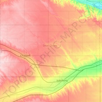
Deuel County topographic map
Interactive map
Click on the map to display elevation.
About this map
Name: Deuel County topographic map, elevation, terrain.
Location: Deuel County, Nebraska, United States (41.00214 -102.62055 41.22144 -102.05053)
Average elevation: 3,717 ft
Minimum elevation: 3,264 ft
Maximum elevation: 4,052 ft
Nebraska trails, hiking, mountain biking, running and outdoor activities
Other topographic maps
Click on a map to view its topography, its elevation and its terrain.
Norfolk Mobile Home Community
United States > Nebraska > Madison County > Norfolk
Average elevation: 1,535 ft
Westside Plaza Mobile Home Park
United States > Nebraska > Phelps County > Holdrege
Average elevation: 2,323 ft
Missouri River Basin Lewis & Clark Interpretive Trail & Visitors Center
United States > Nebraska > Otoe County
Average elevation: 1,010 ft
Old Fort Kearny Historical Marker
United States > Nebraska > Otoe County > Nebraska City
Average elevation: 981 ft
Kearney Cotton Mill Historical Marker
United States > Nebraska > Buffalo County > Cottonmill Mobile Home Court
Average elevation: 2,218 ft
Bloomfield Trailer Court
United States > Nebraska > Knox County > Bloomfield
Average elevation: 1,739 ft