
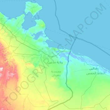
Médenine topographic map
Interactive map
Click on the map to display elevation.
About this map
Name: Médenine topographic map, elevation, terrain.
Location: Médenine, Tunisia (32.24992 9.70964 33.91558 11.59994)
Average elevation: 213 ft
Minimum elevation: -16 ft
Maximum elevation: 2,077 ft
Other topographic maps
Click on a map to view its topography, its elevation and its terrain.
Bizerte
Tunisia > Bizerte > بوبكر باكير
The bridge leads to the motorway A4 leading to Tunis–Carthage International Airport and the capital. On the town side the P11 passes semi-rural Louata, hugs Ichkeul Lake and branches into a western route, the P7, leading directly to Tabarka on the coast next to the Algerian border. The P11 leads south-west…
Average elevation: 92 ft
Thala
Tunisia > Kasserine > تالة الغربية
Thala (Arabic: تالة, romanized: Tāla) is a town and commune in Tunisia. It is located in the Kasserine Governorate since 1956. As of the 2004 census it had 13,968 inhabitants. The altitude of Thala is 1,017 metres (3,337 ft), which makes it the highest and the coldest town in the country.
Average elevation: 3,215 ft