
Carroll County topographic map
Interactive map
Click on the map to display elevation.
About this map
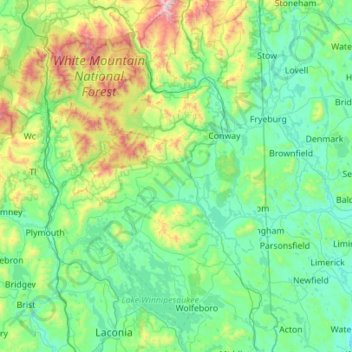
Name: Carroll County topographic map, elevation, terrain.
Location: Carroll County, New Hampshire, United States (43.48219 -71.56460 44.28480 -70.95064)
Average elevation: 1,168 ft
Minimum elevation: 217 ft
Maximum elevation: 6,240 ft
New Hampshire trails, hiking, mountain biking, running and outdoor activities
Other topographic maps
Click on a map to view its topography, its elevation and its terrain.
Hampton Beach
United States > New Hampshire > Rockingham County > Hampton Beach
Average elevation: 7 ft
Mount Washington
United States > New Hampshire > Coos County
Mount Washington, in New Hampshire, is the highest peak in the Northeastern United States at 6,288.2 ft (1,916.6 m) and the most topographically prominent mountain east of the Mississippi River.
Average elevation: 5,144 ft
Crotched Mountain
United States > New Hampshire > Hillsborough County > Francestown
Average elevation: 1,375 ft
Rattlesnake Island
United States > New Hampshire > Belknap County > Alton
Rattlesnake Island is about 2 miles (3 km) long, and approximately 5 miles (8 km) around its shore. The topography varies greatly. Some sections of the island are quite steep, with the land rising steeply from the shore (affording views of the area), while other sections, particularly on the "peninsula", which…
Average elevation: 522 ft
Diamond Island
United States > New Hampshire > Belknap County > Gilford > Coleman Point
Average elevation: 505 ft
Milton Three Ponds Dam
United States > New Hampshire > Strafford County > Milton
Average elevation: 525 ft
Mount Adams
United States > New Hampshire > Coos County
Mount Adams, elevation 5,793 feet (1,766 m) above sea level, is a mountain in New Hampshire, the second highest peak in the Northeast United States after its nearby neighbor, Mount Washington. Located in the northern Presidential Range, Mount Adams was named after John Adams, the second President of the United…
Average elevation: 4,524 ft
North Brookline
United States > New Hampshire > Hillsborough County > Brookline
Average elevation: 407 ft
Middle Sugarloaf
United States > New Hampshire > Grafton County > Bethlehem
Average elevation: 1,942 ft
Everrett Field
United States > New Hampshire > Carroll County > Sandwich > Center Sandwich
Average elevation: 719 ft
Perham Corner
United States > New Hampshire > Hillsborough County > Lyndeborough
Average elevation: 551 ft
Winnipesaukee
United States > New Hampshire > Carroll County > Moultonborough
Average elevation: 528 ft
West Peterborough
United States > New Hampshire > Hillsborough County > Peterborough
Average elevation: 981 ft
Big Attitash Mountain
United States > New Hampshire > Carroll County > Bartlett
Average elevation: 2,333 ft
East Merrimack
United States > New Hampshire > Hillsborough County > Merrimack
Average elevation: 180 ft
Stinson Lake
United States > New Hampshire > Grafton County > Rumney > Stinson Lake
Average elevation: 1,509 ft
North Woodstock
United States > New Hampshire > Grafton County > Woodstock
Average elevation: 1,004 ft
Weirs Beach
United States > New Hampshire > Belknap County > Laconia > Interlaken Park
Average elevation: 587 ft
Pinkham Notch
United States > New Hampshire > Coos County
Pinkham Notch (elevation 2032 ft. / 619 m) is a mountain pass in the White Mountains of north-central New Hampshire, United States. The notch is a result of extensive erosion by the Laurentide Ice Sheet during the Wisconsinian ice age. Pinkham Notch was eroded into a glacial U-shaped valley whose walls are…
Average elevation: 2,516 ft
Kelleys Corner
United States > New Hampshire > Merrimack County > Chichester
Average elevation: 518 ft