
Douglas County topographic map
Interactive map
Click on the map to display elevation.
Douglas County
Douglas County's elevation above sea level ranges as low as 740 feet (230 m) at the Chattahoochee River to as high as 1,340 feet (410 m); one of the county's highest elevation points lies inside the city of Douglasville. Andy Mountain, between Villa Rica and Winston – west of Douglasville along Bankhead Highway, has the highest elevation in Douglas County. Two other elevated summits are located in the county, known as Cedar Mountain at 1,257 feet (383 m), and Pine Mountain at 1,180 feet (360 m).
About this map
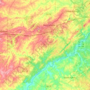
Name: Douglas County topographic map, elevation, terrain.
Location: Douglas County, Georgia, United States (33.57336 -84.91106 33.80626 -84.57785)
Average elevation: 978 ft
Minimum elevation: 692 ft
Maximum elevation: 1,339 ft
Georgia trails, hiking, mountain biking, running and outdoor activities
Other topographic maps
Click on a map to view its topography, its elevation and its terrain.
Stone Mountain
United States > Georgia > DeKalb County
The park is owned by the state of Georgia and is currently managed by Herschend Family Entertainment. At its summit, the elevation is 1,686 feet (514 m) above sea level and 825 feet (251 m) above the surrounding area. Stone Mountain is well known for not only its geology, but also the enormous rock relief on…
Average elevation: 981 ft
Honey Ridge Plantation
United States > Georgia > Houston County > Warner Robins
Average elevation: 377 ft
Georgia International Horse Park
United States > Georgia > Rockdale County > Conyers
Average elevation: 712 ft
Blood Mountain
United States > Georgia > Union County
Blood Mountain is the highest peak on the Georgia section of the Appalachian Trail and the sixth-tallest mountain in Georgia, with an elevation of 4,458 feet (1,359 m). It is located on the border of Lumpkin County with Union County and is within the boundaries of the Chattahoochee National Forest and the…
Average elevation: 3,438 ft
Pine Ridge Country Club Estates
United States > Georgia > Gwinnett County > Lawrenceville
Average elevation: 1,060 ft
Palmetto Pines Mobile Home Park
United States > Georgia > Camden County > Kingsland
Average elevation: 20 ft
Morgantown Baptist Association Dam
United States > Georgia > Fannin County
Average elevation: 2,133 ft