
Blount County topographic map
Interactive map
Click on the map to display elevation.
Blount County
The southern part of Blount County is part of the Great Smoky Mountains, and is protected by the Great Smoky Mountains National Park. The crest of the range forms the county's border with Swain County, North Carolina, and includes Blount's highest point, 5,527-foot (1,685 m) Thunderhead Mountain, and the 4,949-foot (1,508 m) Gregory Bald, a prominent grassy bald. The northern part of the county is part of the Ridge-and-Valley Appalachians. The geologic boundary between the Blue Ridge (which includes the Smokies) and Ridge-and-Valley provinces runs along Chilhowee Mountain, a long and narrow ridge that stretches across the central part of the county. Much of Blount's topography is characterized by elongate ridges and rolling hills— known locally as "The Foothills"— which emanate outward from the Smokies range.
About this map
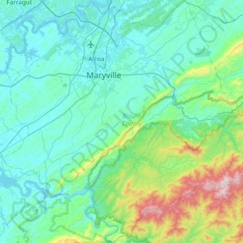
Name: Blount County topographic map, elevation, terrain.
Location: Blount County, East Tennessee, Tennessee, United States (35.46055 -84.18843 35.88713 -83.66320)
Average elevation: 1,480 ft
Minimum elevation: 801 ft
Maximum elevation: 5,420 ft
Tennessee trails, hiking, mountain biking, running and outdoor activities
Other topographic maps
Click on a map to view its topography, its elevation and its terrain.
Pinson Mounds State Archaeological Area
United States > Tennessee > Madison County
Average elevation: 394 ft
Big Fiery Gizzard Creek
United States > Tennessee > Marion County > Kimball
Average elevation: 1,204 ft
Millersville City Park
United States > Tennessee > Robertson County > Millersville
Average elevation: 853 ft
Brainerd
United States > Tennessee > Hamilton County > Chattanooga > Ridgeside
Average elevation: 768 ft
Cherokee Dam - Saddle Dam No. 1
United States > Tennessee > Jefferson County
Average elevation: 1,053 ft
Edwin Warner Park
United States > Tennessee > Davidson County > Nashville > Devonshire Manor
Average elevation: 650 ft
Douglas Dam
United States > Tennessee > Sevier County > Sevierville
The Douglas Project required the construction of ten smaller, earthen saddle dams to fill in gaps along the adjacent ridgeline and permit a higher water elevation than would otherwise be possible. Most of these saddle dams are located in the hills southeast of the main dam. One protects downtown Dandridge,…
Average elevation: 1,024 ft
Evergreen Estates
United States > Tennessee > Montgomery County > Clarksville
Average elevation: 482 ft
Loafer's Corner
United States > Tennessee > Rutherford County > Smyrna > Smyrna
Average elevation: 600 ft
Stonehenge Estates
United States > Tennessee > Williamson County > Brentwood
Average elevation: 840 ft
Barfield Crescent Park
United States > Tennessee > Rutherford County > Murfreesboro
Average elevation: 659 ft
Northcreek Commons
United States > Tennessee > Davidson County > Goodlettsville
Average elevation: 509 ft