
Chiradzulu topographic map
Interactive map
Click on the map to display elevation.
About this map
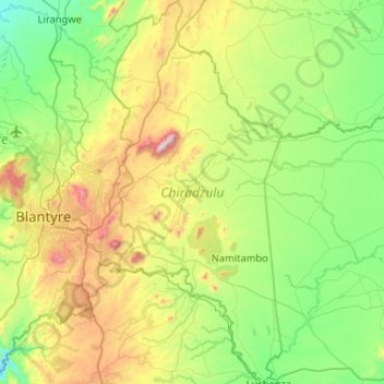
Name: Chiradzulu topographic map, elevation, terrain.
Location: Chiradzulu, Southern Region, Malawi, Malawi (-16.00483 35.09671 -15.50459 35.32676)
Average elevation: 2,808 ft
Minimum elevation: 1,598 ft
Maximum elevation: 5,833 ft
Other topographic maps
Click on a map to view its topography, its elevation and its terrain.
Capital Hill
Capital Hill, Lilongwe, Central Region, AREA 32, Malawi
Average elevation: 3,514 ft
Lake Chilwa
Lake Chilwa, Zomba, Southern Region, Malawi
Average elevation: 2,123 ft