
Grainger County topographic map
Interactive map
Click on the map to display elevation.
Grainger County
Joppa Mountain is located along the Clinch Mountain ridge in central Grainger County in the unincorporated community of Joppa. Buzzard Rock is the summit of the mountain at an elevation of 2,530 feet (770 m) above sea level, making it one of the highest points in Grainger County. At this summit, the neighboring U.S. states of Georgia, Kentucky, North Carolina, and Virginia can be seen, along with the Cumberland Gap and the Great Smoky Mountains range, on a clear day.
About this map
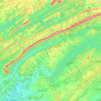
Name: Grainger County topographic map, elevation, terrain.
Location: Grainger County, East Tennessee, Tennessee, United States (36.08053 -83.73286 36.42069 -83.25529)
Average elevation: 1,270 ft
Minimum elevation: 843 ft
Maximum elevation: 2,454 ft
Tennessee trails, hiking, mountain biking, running and outdoor activities
Other topographic maps
Click on a map to view its topography, its elevation and its terrain.
Pinson Mounds State Archaeological Area
United States > Tennessee > Madison County
Average elevation: 394 ft
Big Fiery Gizzard Creek
United States > Tennessee > Marion County > Kimball
Average elevation: 1,204 ft
Millersville City Park
United States > Tennessee > Robertson County > Millersville
Average elevation: 853 ft
Brainerd
United States > Tennessee > Hamilton County > Chattanooga > Ridgeside
Average elevation: 768 ft
Cherokee Dam - Saddle Dam No. 1
United States > Tennessee > Jefferson County
Average elevation: 1,053 ft
Edwin Warner Park
United States > Tennessee > Davidson County > Nashville > Devonshire Manor
Average elevation: 650 ft
Douglas Dam
United States > Tennessee > Sevier County > Sevierville
The Douglas Project required the construction of ten smaller, earthen saddle dams to fill in gaps along the adjacent ridgeline and permit a higher water elevation than would otherwise be possible. Most of these saddle dams are located in the hills southeast of the main dam. One protects downtown Dandridge,…
Average elevation: 1,024 ft
Loafer's Corner
United States > Tennessee > Rutherford County > Smyrna > Smyrna
Average elevation: 600 ft
Evergreen Estates
United States > Tennessee > Montgomery County > Clarksville
Average elevation: 482 ft
Stonehenge Estates
United States > Tennessee > Williamson County > Brentwood
Average elevation: 840 ft
Barfield Crescent Park
United States > Tennessee > Rutherford County > Murfreesboro
Average elevation: 659 ft