
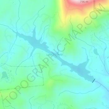
Lake Laceola topographic map
Interactive map
Click on the map to display elevation.
About this map
Name: Lake Laceola topographic map, elevation, terrain.
Location: Lake Laceola, White County, Georgia, United States (34.60471 -83.74391 34.61833 -83.71906)
Average elevation: 1,624 ft
Minimum elevation: 1,378 ft
Maximum elevation: 2,516 ft
Georgia trails, hiking, mountain biking, running and outdoor activities
Other topographic maps
Click on a map to view its topography, its elevation and its terrain.
Augusta
United States > Georgia > Augusta
As with the rest of the state, Augusta has a humid subtropical climate (Köppen Cfa), with short, mild winters, very hot, humid summers, and a wide diurnal temperature variation throughout much of the year, despite its low elevation and moisture. The monthly daily average temperature ranges from 45.4 °F (7.4…
Average elevation: 295 ft
Atlanta
United States > Georgia > Fulton County
Atlanta (/ætˈlæntə/ at-LAN-tə) is the capital and most populous city of the U.S. state of Georgia. It is the seat of Fulton County, the most populous county in Georgia. With a population of 498,715 living within the city limits, it is the eighth most populous city in the Southeast and 38th most populous…
Average elevation: 935 ft
Brunswick
United States > Georgia > Glynn County
The city is the lowest in the U.S. state of Georgia, with an elevation of only 10 to 14 feet (3.0 to 4.3 m) above sea level. According to the U.S. Census Bureau, Brunswick's land area is 32.4 square miles (83.8 km2). Its total area is 42.4 square miles (109.8 km2); 10.0 square miles (26.0 km2) of this is water.
Average elevation: 7 ft
Wilmington Island
United States > Georgia > Chatham County > Wilmington Island
Average elevation: 10 ft
Alcovy Mountain
United States > Georgia > Walton County
Alcovy Mountain is a monadnock in the U.S. state of Georgia similar to Kennesaw Mountain in the city of Marietta. It is located in Walton County four miles south of the city of Monroe. With a summit elevation of 1,128 ft (344 m), the mountain is the highest point in Walton County, and is the southeastern-most…
Average elevation: 745 ft
Fort Benning
United States > Georgia > Chattahoochee County > Chattahoochee County
Average elevation: 312 ft
Lake Hartwell
United States > Georgia > Stephens County > Anderson
Lake Hartwell is a man-made reservoir bordering Georgia and South Carolina and encompassing parts of the Savannah, Tugaloo, and Seneca rivers. Lake Hartwell is one of the Southeastern United States' largest recreation lakes. The lake was created by the construction of the Hartwell Dam, completed in 1962 and…
Average elevation: 879 ft
Waverly Woods
United States > Georgia > Athens-Clarke County > Athens-Clarke County Unified Government
Average elevation: 679 ft
Chattahoochee River National Recreation Area
United States > Georgia > Forsyth County > Atlanta
Average elevation: 1,037 ft
Tiger
United States > Georgia > Rabun County
Tiger lies in the extreme northeastern part of the state, just a few miles west of the Georgia-South Carolina border, and a few miles south of the Georgia-North Carolina border. The town's elevation is 1,962 feet (598 m), with several wooded hilltops reaching elevations of 2,100 to 2,200 feet. The town sits at…
Average elevation: 1,995 ft
Lake Lanier
United States > Georgia > Forsyth County > Cumming
According to the Army Corps of Engineers, the Dam has a current installed capacity of 126 megawatts and a hydraulic head of 136 feet. Other pertinent information on the reservoir, power plant, etc. can be found on the Mobile District Corps of Engineers web site. Also, historic operational information on lake…
Average elevation: 1,152 ft
Alto
United States > Georgia > Banks County
Alto was so named on account of its (relatively) lofty elevation (1,394 feet above mean sea level). A post office called Alto has been in operation since 1879. The town incorporated in 1895.
Average elevation: 1,335 ft
Nicholls
United States > Georgia > Coffee County
Nicholls, Georgia is in the Wiregrass Region of the United States and inherits its topography and ecological diversity.
Average elevation: 177 ft