
Cortina d'Ampezzo topographic map
Interactive map
Click on the map to display elevation.
Cortina d'Ampezzo
Among the surrounding mountains are Tofane to the west, Pomagagnon to the north, Cristallo to the northeast, Faloria and Sorapiss to the east, and Becco di Mezzodì, Croda da Lago and Cinque Torri to the south. The town centre is located at an elevation of 1,224 metres (4,016 ft), although the highest summit is that of the Tofana di Mezzo, which towers at 3,244 metres (10,643 ft). There are numerous fast flowing rivers, streams and small lakes in the territory, such as the Ghedina, Pianozes and d'Ajal, which fill particularly during the summer snow-melt season. Fauna include marmots, roe deer, chamois and hares and, on occasion, wolves, bears and lynx.
About this map
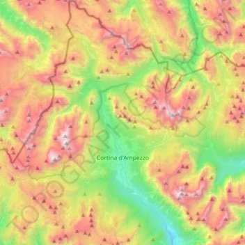
Name: Cortina d'Ampezzo topographic map, elevation, terrain.
Location: Cortina d'Ampezzo, Belluno, Veneto, 32043, Italy (46.46177 11.98854 46.67500 12.25759)
Average elevation: 6,476 ft
Minimum elevation: 3,189 ft
Maximum elevation: 10,518 ft
Other topographic maps
Click on a map to view its topography, its elevation and its terrain.
Tre Cime di Lavaredo - Drei Zinnen
Italy > Veneto > Belluno > Auronzo di Cadore
Until 1919 the peaks formed part of the border between Italy and Austria-Hungary. Now they lie on the border between the Italian provinces of South Tyrol and Belluno and still are a part of the linguistic boundary between German-speaking and Italian-speaking majorities. The Cima Grande has an elevation of…
Average elevation: 7,356 ft
Sas de Stria
Italy > Veneto > Belluno > Cortina d'Ampezzo
Sass de Stria is a mountain of the Veneto, Italy. It has an elevation of 2,477 meters. During the First World War, the mountain and surrounding area was the scene of fighting between Italy and Austria-Hungary.
Average elevation: 7,014 ft
Tre Cime di Lavaredo - Drei Zinnen
Italy > Veneto > Belluno > Auronzo di Cadore
Until 1919 the peaks formed part of the border between Italy and Austria-Hungary. Now they lie on the border between the Italian provinces of South Tyrol and Belluno and still are a part of the linguistic boundary between German-speaking and Italian-speaking majorities. The Cima Grande has an elevation of…
Average elevation: 7,356 ft
Cortina d'Ampezzo
Italy > Veneto > Belluno > Cortina d'Ampezzo > Cortina d'Ampezzo
Among the surrounding mountains are Tofane to the west, Pomagagnon to the north, Cristallo to the northeast, Faloria and Sorapiss to the east, and Becco di Mezzodì, Croda da Lago and Cinque Torri to the south. Monte Antelao (Nantelou in Ladin) is at 3264 m the highest mountain in the Ampezzo Dolomites and the…
Average elevation: 5,410 ft
Pieve di Cadore
Italy > Veneto > Belluno > Pieve di Cadore > Pieve di Cadore
Average elevation: 3,661 ft