Geolocate

Uiwang-si topographic map

Interactive map

Click on the map to display elevation.

About this map

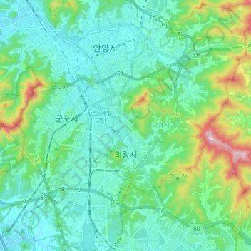
Name: Uiwang-si topographic map, elevation, terrain.

Location: Uiwang-si, Gyeonggi, South Korea (37.30037 126.92924 37.41562 127.04684)

Average elevation: 410 ft

Minimum elevation: 52 ft

Maximum elevation: 1,808 ft

Other topographic maps

Click on a map to view its topography, its elevation and its terrain.

Bugyang-ri

South Korea > Hwaseong-si

Average elevation: 203 ft

Soseong-ri

South Korea > Seongju-gun > Chojeon-myeon

Average elevation: 1,086 ft

Udu-ri

South Korea > Yeosu-si

Average elevation: 52 ft

Obong-ri

South Korea > Naju-si

Average elevation: 279 ft

Yeongsong-ri

South Korea > Pocheon-si

Average elevation: 381 ft

Hongwon-ri

South Korea > Cheorwon-gun

Average elevation: 856 ft

평택상하수도사업소

South Korea

Average elevation: 210 ft

Austrailia Pavilion

South Korea > Gwacheon-si

Average elevation: 472 ft

Daebeop-ri

South Korea > Goseong-gun

Average elevation: 591 ft

Hallasan

South Korea > Jeju

The occurrence of the highest temperature coincides with the formation position of the eddy, and when the wind is weak, the eddy forms in the middle mountain region. When the wind is weak, the warmth is accumulated in the middle layer, so the maximum temperature in the mid-mountainous area is higher than the…

Average elevation: 5,420 ft

Deogyang-gu

South Korea > Goyang-si

Average elevation: 75 ft

Ssangji-ri

South Korea > Suncheon-si

Average elevation: 591 ft

Bugam-ri

South Korea > Boeun-gun

Average elevation: 1,342 ft

Hoamsan Mountain

South Korea > Yeosu-si

Average elevation: 325 ft

Gapyeong

South Korea > Gapyeong-gun

Average elevation: 515 ft

Seattle Park

South Korea > Daejeon

Average elevation: 167 ft

Sin-gok-ri

South Korea > Miryang-si

Average elevation: 978 ft

Incheon-ri

South Korea > Nonsan-si

Average elevation: 344 ft

Punggye-ri

South Korea > Icheon-si

Average elevation: 243 ft

Daehoesan-ri

South Korea > Pocheon-si

Average elevation: 705 ft

Udo-myeon

South Korea

Average elevation: 7 ft

Muan-eup

South Korea > Muan-gun

Average elevation: 141 ft

우도

South Korea > Ganghwa-gun > Incheon > Seodo-myeon

Average elevation: 3 ft

Inwangsan (Mt.)

South Korea > Seoul

Average elevation: 371 ft

Seoraksan National Park

South Korea > Goseong-gun

Average elevation: 2,037 ft

Gye-dong

South Korea > Seoul

Average elevation: 249 ft

Bukhan River

South Korea > Chuncheon-si

Average elevation: 486 ft

Sijeon-dong

South Korea > Yeosu-si > Sijeon-dong

Average elevation: 262 ft

1156

South Korea > Pyeongchang-gun

Average elevation: 3,330 ft

Dokdo Island

South Korea > Dokdo-ri

Average elevation: 0 ft

Gyeonggi

South Korea > Gyeonggi-do > Suwon-si > Gyo-dong

Average elevation: 174 ft

Gangwon

South Korea > Gangwon-do > Chuncheon-si > Bongui-dong

Average elevation: 312 ft

Aesan-ri

South Korea > Gangwon-do > Aesan-ri

Average elevation: 1,473 ft

Uiwang

South Korea > Gyeonggi-do > Uiwang

Average elevation: 272 ft

Jeju-si

South Korea > Jeju-do > Jeju-si

Average elevation: 863 ft

Orim-dong

South Korea > Yeosu-si > Orim-dong

Average elevation: 351 ft

Sonyang-myeon

South Korea > Sonyang-myeon

Average elevation: 157 ft

Sajik-dong

South Korea > Cheonan-si > Sajik-dong

Average elevation: 171 ft

Doil-dong

South Korea > Pyeongtaek-si > Doil-dong

Average elevation: 194 ft

Hwapo-ri

South Korea > Goseong-gun > Geojin-eup > Hwapo-ri

Average elevation: 49 ft

Mangyeong-eup

South Korea > Gimje-si > Mangyeong-eup

Average elevation: 30 ft

Gapa Island

South Korea > Seogwipo-si > Gapa-ri

Average elevation: 3 ft

Panmunjeom

South Korea > Paju-si

Average elevation: 89 ft

Susong-dong

South Korea > Seoul > Susong-dong

Average elevation: 223 ft

Haui-myeon

South Korea > Sinan-gun > Haui-myeon

Average elevation: 30 ft

Songgok-ri

South Korea > Hwaseong-si

Average elevation: 180 ft

Oji-ri

South Korea > Gokseong-gun > Ogok-myeon > Oji-ri

Average elevation: 358 ft