
Tigray topographic map
Interactive map
Click on the map to display elevation.
Tigray
Of the 10 largest cities in Tigray, Maychew has the highest elevation at 2479 meter above sea level. Plenty of smaller towns, like Atsbi and Edaga Hamus are located at even higher elevations. Of the large cities, Humera is located at the lowest altitude (585 m).
About this map
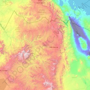
Name: Tigray topographic map, elevation, terrain.
Location: Tigray, Ethiopia (12.25628 36.44639 14.89434 39.99175)
Average elevation: 4,416 ft
Minimum elevation: -413 ft
Maximum elevation: 14,495 ft
Other topographic maps
Click on a map to view its topography, its elevation and its terrain.
Asosa
Ethiopia > Benishangul-Gumuz Region
Asosa or Assosa is the capital of Benishangul-Gumuz Region, Ethiopia. Located in the Asosa Zone, this town has a latitude and longitude of 10°04′N 34°31′E / 10.067°N 34.517°E / 10.067; 34.517, with an elevation of 1,570 meters.
Average elevation: 4,268 ft
Hossana
Ethiopia > Central Ethiopia Regional State
Hosaena, Hossana or Hosaina is a town which level as a woreda in southern Ethiopia, and currently serve as the administrative center of Hadiya Zone and Central Ethiopia Regional State as well. Geographically located to the central south of Ethiopia, with a latitude and longitude of 7°33′N 37°51′E /…
Average elevation: 7,398 ft
Adwa
Adwa (Tigrinya: ዓድዋ; Amharic: ዐድዋ; also spelled Adowa or Aduwa) is a town and separate woreda in Tigray Region, Ethiopia. It is best known as the community closest to the site of the 1896 Battle of Adwa, in which Ethiopian soldiers defeated Italian troops, thus being one of the few African nations…
Average elevation: 6,437 ft
Robe
Arsi Robe is a town in south-eastern Oromia. It is named after the nearby Robe River. It is the administrative centre of the Robe (Aanaa) in the Arsi Zone of the Oromia State, this town has a latitude and longitude of 09°36′N 39°08′E / 9.600°N 39.133°E / 9.600; 39.133 with an elevation of 2435…
Average elevation: 8,005 ft
Freweyni
Freweyni (also known as Sinkata or ferawun) is a town in northern Ethiopia. Located 80 kilometers north of Mekele in the Misraqawi Zone of the Tigray Region (or kilil) of Ethiopia, this town has a latitude and longitude of 14°3′N 39°34′E / 14.050°N 39.567°E / 14.050; 39.567 with an elevation…
Average elevation: 8,107 ft
Shoa Robit
Shewa Robit (Amharic: ሸዋ ሮቢት)also known as Robi, Shah Robit, Shoa Robit or Robit is a town in north-central Ethiopia. Located in the North Shewa Zone of the Amhara Region, this town has a longitude and latitude of 10°00′N 39°54′E / 10.000°N 39.900°E / 10.000; 39.900 with an elevation…
Average elevation: 4,462 ft
Humera
Humera (Tigrinya: ሑመራ; Amharic: ሁመራ) is a town in the Kafta Humera woreda in the Tigray Region of Ethiopia. Located in the Western Zone the town has an elevation of 585 metres (1,919 ft) above sea level. The Tekezé river borders the town to the north. Humera is a very important regional…
Average elevation: 1,949 ft
Jijiga
Jijiga (Somali: Jigjiga, Amharic: ጅጅጋ, Jijiga) is the capital city of Somali Region, Ethiopia. It became the capital of the Somali Region in 1995 after it was moved from Gode. Located in the Fafan Zone with 75 km (37 mi) west of the border with Somaliland, the city has an elevation of 1,634 metres above…
Average elevation: 5,682 ft
Bonga
Ethiopia > South West Ethiopia Peoples
Bonga is a town, woreda and one of the multicapital of the South West Ethiopia Peoples' Region in Ethiopia. Located in the Keffa Zone upon a hill in the upper Barta valley, it has a latitude and longitude of 7°16′N 36°14′E / 7.267°N 36.233°E / 7.267; 36.233 with an elevation of 1,714 meters…
Average elevation: 5,804 ft
Metu
Metu (Oromo: Mattuu) is a market town and separate woreda in south-western Ethiopia. Located in the Illubabor Zone of the Oromia along the Sor River, this town has a latitude and longitude of 8°18′N 35°35′E / 8.300°N 35.583°E / 8.300; 35.583 and an altitude of 1605 meters. Metu was the capital…
Average elevation: 5,518 ft
Debre Birhan
Debre Birhan (Amharic: ደብረ ብርሃን) is a city in central Ethiopia. Located in the Semien Shewa Zone of Amhara Region, about 120 kilometers north east of Addis Ababa on Ethiopian highway 2, the town has an elevation of 2,840 meters, which makes it the highest town in Africa. It was an early capital…
Average elevation: 8,924 ft
Chiro
Chiro (also called Asebe Teferi or Asba Littoria; Afaan Oromo: Ciroo) is a town and Aanaa in eastern Ethiopia. Located in the West Hararghe Zone in Oromia Regional State, Ethiopia Ahmar Mountains, it has a latitude and longitude of 9°05′N 40°52′E / 9.083°N 40.867°E / 9.083; 40.867 and an…
Average elevation: 6,135 ft
Entoto
Ethiopia > Oromia Region > Sululta
The Ethiopian Heritage Trust, a non-profit, non-governmental organization, is working actively to change part of the mountain to its old state, a natural park. Entoto Natural Park is the northeastern rim of Addis Abeba, on the southeastern slopes of Mt. Entoto, covering an area of 1,300 hectares. It is…
Average elevation: 9,905 ft
Harena Forest
The Harenna Forest is a montane tropical evergreen forest in Ethiopia's Bale Mountains. The forest covers the southern slope of the mountains, extending from 1450 to 3200 meters elevation. The Bale Mountains are in Ethiopia's Oromia Region, and form the southwestern portion of the Ethiopian Highlands.
Average elevation: 6,654 ft
Ogaden Desert
The Ogaden is a plateau, with an elevation above sea level that ranges from 1,500 metres (4,900 ft) in the northwest, falling to about 300 metres (980 ft) along the southern limits and the Wabi Shebelle valley. The areas with altitudes between 1,400 and 1,600 metres (4,600 and 5,200 ft) are characterised as…
Average elevation: 1,916 ft
Hawassa
Hawassa (Amharic: አዋሳ; ʾäwasa, also spelled Awassa or Awasa) known historically as Adare is a city in Ethiopia, on the shores of Lake Awassa in the Great Rift Valley. It is 273 km (170 mi) south of Addis Ababa via Bishoftu, 130 km (81 mi) east of Sodo, and 75 km (47 mi) north of Dilla. The town serves…
Average elevation: 6,109 ft
Metemma
Metemma (Amharic: መተማ), also known as Metemma Yohannes, is a town in northwestern Ethiopia, on the border with Sudan. Located in the Semien Gondar Zone of the Amhara Region, Metemma has a latitude and longitude of 12°58′N 36°12′E / 12.967°N 36.200°E / 12.967; 36.200 with an elevation of…
Average elevation: 2,421 ft
Sire
Sire (also transliterated "Sirie") is a town in south-western Oromia. Located in the Arsi Zone of the Oromia, Ethiopia. This town has a latitude and longitude of 08°17′N 39°27′E / 8.283°N 39.450°E / 8.283; 39.450 with an altitude of 1793 meters above sea level. It is administrative center of…
Average elevation: 6,670 ft
Asassa
Asasa is a town in southeastern Ethiopia. Located in the West Arsi Zone of the Oromia Region, this town has a latitude and longitude of 07°06′N 39°12′E / 7.100°N 39.200°E / 7.100; 39.200 with an elevation of 2367 meters above sea level. It is the administrative center of Gedeb Asasa woreda.
Average elevation: 7,815 ft
Moyale
Moyale has a hot semi-arid climate (Köppen BSh) moderated somewhat by altitude. Typically for East Africa, there are two rainy seasons: the “long rains” from March to May and the weaker, less reliable “short rains” in October and November.
Average elevation: 3,593 ft
Wolaita Sodo
Ethiopia > South Ethiopia Regional State
Sodo (Amharic: ሶዶ) or officially Wolaita Sodo (Amharic: ወላይታ ሶዶ, Wolaytta: Wolaytta Sooddo) is a city in south Ethiopia. The City is a political and administrative center of the Wolaita Zone and South Ethiopia Regional State. It has a latitude and longitude of 6°54′N 37°45′E /…
Average elevation: 6,145 ft
Dessie
Dessie (Amharic: ደሴ, romanized: Däse; also spelled Dese or Dessye) is a town in north-central Ethiopia. Located in the South Wollo Zone of the Amhara Region, it sits at a latitude and longitude of 11°8′N 39°38′E / 11.133°N 39.633°E / 11.133; 39.633, with an elevation between 2,470 and…
Average elevation: 8,038 ft
Alamata
Alamata (Tigrinya: ኣላማጣ ) is a town in the Tigray Region of Ethiopia. Located in the Debubawi (Southern) zone of Tigray it has a latitude and longitude of 12°25′N 39°33′E / 12.417°N 39.550°E / 12.417; 39.550 and an elevation of 1,520 metres (4,990 ft) above sea level and is located…
Average elevation: 5,164 ft
Addis Ababa
Ethiopia > Addis Ababa > Arada
Moreover, the city held strong social organizations pattern prior Italian invasion. According to Richard Pankhurst (1968), the city accelerated population growth due to factors of provisional governors and their troops, the 1892 famine, eventually the Battle of Adwa. Another include the 1907 land act,…
Average elevation: 8,258 ft
Wolaita Sodo
Ethiopia > South Ethiopia Regional State
Sodo (Amharic: ሶዶ) or officially Wolaita Sodo (Amharic: ወላይታ ሶዶ, Wolaytta: Wolaytta Sooddo) is a city in south Ethiopia. The City is a political and administrative center of the Wolaita Zone and South Ethiopia Regional State. It has a latitude and longitude of 6°54′N 37°45′E /…
Average elevation: 6,145 ft
Adwa
Adwa (Tigrinya: ዓድዋ; Amharic: ዐድዋ; also spelled Adowa or Aduwa) is a town and separate woreda in Tigray Region, Ethiopia. It is best known as the community closest to the site of the 1896 Battle of Adwa, in which Ethiopian soldiers defeated Italian troops, thus being one of the few African nations…
Average elevation: 6,437 ft