
Amber topographic map
Interactive map
Click on the map to display elevation.
About this map
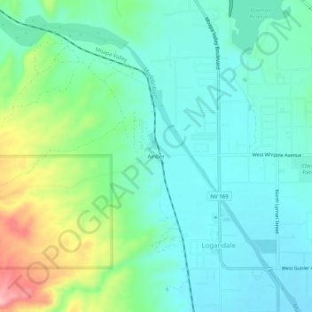
Name: Amber topographic map, elevation, terrain.
Average elevation: 1,467 ft
Minimum elevation: 1,362 ft
Maximum elevation: 1,729 ft
Clark County trails, hiking, mountain biking, running and outdoor activities
Other topographic maps
Click on a map to view its topography, its elevation and its terrain.
Las Vegas
United States > Nevada > Clark County
The peaks surrounding Las Vegas reach elevations of over 10,000 feet (3,000 m), and act as barriers to the strong flow of moisture from the surrounding area. The elevation is approximately 2,030 ft (620 m) above sea level. According to the United States Census Bureau, the city has a total area of 135.86 sq mi…
Average elevation: 2,480 ft
Las Vegas
United States > Nevada > Clark County
Las Vegas is characterized by its distinctive topography, which features a mix of arid desert landscapes and mountainous terrain. The city itself sits at an elevation of approximately 2,030 feet (620 meters) above sea level, while the surrounding peaks reach heights exceeding 10,000 feet (3,000 meters),…
Average elevation: 2,480 ft
Henderson
United States > Nevada > Clark County
Henderson is a city in Clark County, Nevada, United States, about 16 miles (26 km) southeast of downtown Las Vegas. It is the second largest city in Nevada, after Las Vegas, with an estimated population of 320,189 in 2019. The city is part of the Las Vegas Valley. Henderson occupies the southeastern end of the…
Average elevation: 2,267 ft
Mount Charleston
United States > Nevada > Clark County
The town of Mount Charleston is named for nearby Mount Charleston whose Charleston Peak at 11,916 feet (3,632 m) is the highest point in Clark County. The town of Mount Charleston is in a valley of the Spring Mountains to the northwest of Las Vegas, noted for its hiking trails. It is also known for its Retreat…
Average elevation: 8,399 ft
Las Vegas Valley
United States > Nevada > Clark County
The Las Vegas Valley lies in a relatively high-altitude portion of the Mojave Desert, with a subtropical hot-desert climate. The Valley generally averages less than 5 in (130 mm) of rain annually. Daily daytime summer temperatures in July and August typically range from 100 °F (38 °C) to 110 °F (43 °C),…
Average elevation: 2,927 ft
Henderson
United States > Nevada > Clark County
Henderson is a city in Clark County, Nevada, United States, about 16 miles (26 km) southeast of downtown Las Vegas. It is the second largest city in Nevada, after Las Vegas, with an estimated population of 320,189 in 2019. The city is part of the Las Vegas Valley. Henderson occupies the southeastern end of the…
Average elevation: 2,267 ft
Moapa Valley
United States > Nevada > Clark County
Moapa Valley is at an elevation of 1,265 ft (386 m) above sea level. The United States Census Bureau gives the census-designated place (CDP) of Moapa Valley (which may not coincide exactly with the town boundaries) a total area of 43.7 square miles (113.2 km2), of which 43.7 square miles (113.1 km2) is land…
Average elevation: 1,706 ft
Valley of Fire State Park
United States > Nevada > Clark County
Valley of Fire is located in the Mojave Desert 50 miles (80 km) northeast of Las Vegas, at an elevation between 1,320–3,009 feet (402–917 m). It abuts the Lake Mead National Recreation Area on the east at the Virgin River confluence. It lies in a 4 by 6 mi (6.4 by 9.7 km) basin.
Average elevation: 2,054 ft
Las Vegas
United States > Nevada > Clark County
The peaks surrounding Las Vegas reach elevations of over 10,000 feet (3,000 m), and act as barriers to the strong flow of moisture from the surrounding area. The elevation is approximately 2,030 ft (620 m) above sea level. According to the United States Census Bureau, the city has a total area of 135.86 sq mi…
Average elevation: 2,480 ft
North Las Vegas
United States > Nevada > Clark County
On May 13, 1964, First Lieutenant Raynor Lee Hebert, a student pilot from Port Arthur, Texas, took off from Nellis Air Force Base at approximately 2:00 PM on an F-105 fighter jet. He radioed his flight leader saying that he could not retract his nose gear, and thus couldn't gain altitude. He was at an height…
Average elevation: 2,244 ft
Indian Springs
United States > Nevada > Clark County > Indian Springs
One year later, Indian Springs was reactivated as Indian Springs Air Force Base by the new United States Air Force, with a new role as a new weapons systems and aircraft research and testing. Among these missions were support for nuclear arms testing at the Nevada Proving Grounds, high-altitude balloon search…
Average elevation: 3,537 ft
Las Vegas
United States > Nevada > Clark County
The peaks surrounding Las Vegas reach elevations of over 10,000 feet (3,000 m) and act as barriers to the strong flow of moisture from the surrounding area. The elevation is approximately 2,030 ft (620 m) above sea level. According to the United States Census Bureau, the city has an area of 135.86 sq mi (351.9…
Average elevation: 2,480 ft
Las Vegas
United States > Nevada > Clark County
The city's elevation is approximately 2,030 ft (620 m) above sea level, though the surrounding peaks reach elevations of over 10,000 feet (3,000 m) and act as barriers to the strong flow of moisture from the surrounding area. According to the United States Census Bureau, the city has an area of 135.86 sq mi…
Average elevation: 2,480 ft
Mount Charleston
United States > Nevada > Clark County
The town of Mount Charleston is named for nearby Mount Charleston whose Charleston Peak at 11,916 feet (3,632 m) is the highest point in Clark County. The town of Mount Charleston is in a valley of the Spring Mountains to the northwest of Las Vegas, noted for its hiking trails. It is also known for its Retreat…
Average elevation: 8,399 ft
Moapa Valley
United States > Nevada > Clark County
Moapa Valley is at an elevation of 1,265 ft (386 m) above sea level. The United States Census Bureau gives the census-designated place (CDP) of Moapa Valley (which may not coincide exactly with the town boundaries) a total area of 43.7 square miles (113.2 km2), of which 43.7 square miles (113.1 km2) is land…
Average elevation: 1,706 ft
Las Vegas
United States > Nevada > Clark County
The peaks surrounding Las Vegas reach elevations of over 10,000 feet (3,000 m), and act as barriers to the strong flow of moisture from the surrounding area. The elevation is approximately 2,030 ft (620 m) above sea level. According to the United States Census Bureau, the city has a total area of 135.86 sq mi…
Average elevation: 2,480 ft
Searchlight
United States > Nevada > Clark County
Searchlight is an unincorporated town and census-designated place (CDP) in Clark County, Nevada, United States, at the topographic saddle between two mountain ranges. At the 2020 census it had a population of 445.
Average elevation: 3,570 ft
North Las Vegas
United States > Nevada > Clark County
On May 13, 1964, First Lieutenant Raynor Lee Hebert, a student pilot from Port Arthur, Texas, took off from Nellis Air Force Base at approximately 2:00 PM on an F-105 fighter jet. He radioed his flight leader saying that he could not retract his nose gear, and thus could not gain altitude. He was at a height…
Average elevation: 2,244 ft
Las Vegas
United States > Nevada > Clark County
The peaks surrounding Las Vegas reach elevations of over 10,000 feet (3,000 m), and act as barriers to the strong flow of moisture from the surrounding area. The elevation is approximately 2,030 ft (620 m) above sea level. According to the United States Census Bureau, the city has a total area of 135.86 sq mi…
Average elevation: 2,480 ft