
Make a donation
Gear up for your next adventure:
As an Amazon Associate, this site earns from qualifying purchases at no extra cost to you.
Champaign County topographic map
Click on the map to display elevation.
Make a donation
Gear up for your next adventure:
As an Amazon Associate, this site earns from qualifying purchases at no extra cost to you.
Champaign County
The topography of Champaign County was formed by the Wisconsin Glacier about 20,000 years before the present. Lobes of ice from what is now Lake Michigan crossed the county, creating a deep pile of glacial soil, up to 300 feet thick, topped by numerous moraines forming small, flat watersheds with no outlets.
Make a donation
Gear up for your next adventure:
As an Amazon Associate, this site earns from qualifying purchases at no extra cost to you.
About this map
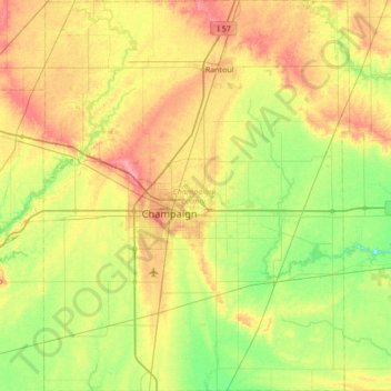
Name: Champaign County topographic map, elevation, terrain.
Location: Champaign County, Illinois, United States (39.87910 -88.46357 40.40068 -87.92876)
Average elevation: 712 ft
Minimum elevation: 614 ft
Maximum elevation: 853 ft
Illinois trails, hiking, mountain biking, running and outdoor activities
Make a donation
Gear up for your next adventure:
As an Amazon Associate, this site earns from qualifying purchases at no extra cost to you.
Other topographic maps
Click on a map to view its topography, its elevation and its terrain.
Make a donation
Gear up for your next adventure:
As an Amazon Associate, this site earns from qualifying purchases at no extra cost to you.
Make a donation
Gear up for your next adventure:
As an Amazon Associate, this site earns from qualifying purchases at no extra cost to you.
Make a donation
Gear up for your next adventure:
As an Amazon Associate, this site earns from qualifying purchases at no extra cost to you.
Make a donation
Gear up for your next adventure:
As an Amazon Associate, this site earns from qualifying purchases at no extra cost to you.
Make a donation
Gear up for your next adventure:
As an Amazon Associate, this site earns from qualifying purchases at no extra cost to you.
Make a donation
Gear up for your next adventure:
As an Amazon Associate, this site earns from qualifying purchases at no extra cost to you.
Make a donation
Gear up for your next adventure:
As an Amazon Associate, this site earns from qualifying purchases at no extra cost to you.
Make a donation
Gear up for your next adventure:
As an Amazon Associate, this site earns from qualifying purchases at no extra cost to you.
Make a donation
Gear up for your next adventure:
As an Amazon Associate, this site earns from qualifying purchases at no extra cost to you.
Make a donation
Gear up for your next adventure:
As an Amazon Associate, this site earns from qualifying purchases at no extra cost to you.
Make a donation
Gear up for your next adventure:
As an Amazon Associate, this site earns from qualifying purchases at no extra cost to you.
Elmhurst
United States > Illinois > DuPage County
Due to local topography, the town has had a tendency to flood in the past after large rainfalls; the city is currently undertaking a large effort to mitigate future flooding.
Average elevation: 679 ft
Make a donation
Gear up for your next adventure:
As an Amazon Associate, this site earns from qualifying purchases at no extra cost to you.
Make a donation
Gear up for your next adventure:
As an Amazon Associate, this site earns from qualifying purchases at no extra cost to you.
Make a donation
Gear up for your next adventure:
As an Amazon Associate, this site earns from qualifying purchases at no extra cost to you.
Make a donation
Gear up for your next adventure:
As an Amazon Associate, this site earns from qualifying purchases at no extra cost to you.
Make a donation
Gear up for your next adventure:
As an Amazon Associate, this site earns from qualifying purchases at no extra cost to you.
Lowest Point in Illinois
United States > Illinois > Alexander County > Cairo
Average elevation: 305 ft
Make a donation
Gear up for your next adventure:
As an Amazon Associate, this site earns from qualifying purchases at no extra cost to you.
Make a donation
Gear up for your next adventure:
As an Amazon Associate, this site earns from qualifying purchases at no extra cost to you.
Make a donation
Gear up for your next adventure:
As an Amazon Associate, this site earns from qualifying purchases at no extra cost to you.
Make a donation
Gear up for your next adventure:
As an Amazon Associate, this site earns from qualifying purchases at no extra cost to you.
Elmhurst
United States > Illinois > DuPage County
Due to local topography, the town has had a tendency to flood in the past after large rainfalls; the city is currently undertaking a large effort to mitigate future flooding.
Average elevation: 679 ft
Make a donation
Gear up for your next adventure:
As an Amazon Associate, this site earns from qualifying purchases at no extra cost to you.
Make a donation
Gear up for your next adventure:
As an Amazon Associate, this site earns from qualifying purchases at no extra cost to you.
Make a donation
Gear up for your next adventure:
As an Amazon Associate, this site earns from qualifying purchases at no extra cost to you.
Riley
United States > Illinois > McHenry County
Riley, elevation 807 feet (246 m), is an unincorporated community and census-designated place in McHenry County, Illinois, United States. It was named a CDP before the 2020 census, at which time it had a population of 10.
Average elevation: 820 ft
Make a donation
Gear up for your next adventure:
As an Amazon Associate, this site earns from qualifying purchases at no extra cost to you.
Hinsdale
United States > Illinois > Hinsdale
Hinsdale is a village in Cook and DuPage counties in the U.S. state of Illinois. Hinsdale is a western suburb of Chicago. The population was 16,816 at the 2010 census, most of whom lived in DuPage County. The town's ZIP code is 60521, which is listed in the top 1% of wealthiest towns in Illinois as well as the…
Average elevation: 702 ft
Lake Shore Drive Area
United States > Illinois > Jackson County > Carbondale
Average elevation: 440 ft
Make a donation
Gear up for your next adventure:
As an Amazon Associate, this site earns from qualifying purchases at no extra cost to you.