
Newton County topographic map
Interactive map
Click on the map to display elevation.


Newton County
Newton County lies almost entirely within the rugged Boston Mountain range of the Ozark Mountains where elevations exceed 2,500 feet (760 m). The Buffalo National River, a popular destination for canoeing and recreation, runs through the county from west to east. Highway 7, which traverses the county from north to south, has been rated as one of the most scenic drives in the region.
About this map
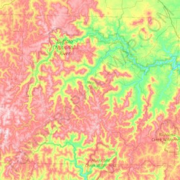
Name: Newton County topographic map, elevation, terrain.
Location: Newton County, Arkansas, United States (35.72468 -93.52606 36.12509 -92.93845)
Average elevation: 1,594 ft
Minimum elevation: 676 ft
Maximum elevation: 2,556 ft
Arkansas trails, hiking, mountain biking, running and outdoor activities
Other topographic maps
Click on a map to view its topography, its elevation and its terrain.
Magazine Mountain
United States > Arkansas > Logan County
Mount Magazine is often called "the highest point between the Alleghenies and the Rockies" (there are mountains located in the Trans-Pecos region of far-west Texas which exceed Mount Magazine in elevation and prominence, although the Trans-Pecos region lies so far south of the Rockies, that region arguably…
Average elevation: 2,198 ft
Left Hand Chute of Little River
United States > Arkansas > Mississippi County
Average elevation: 230 ft