
Make a donation
Gear up for your next adventure:
As an Amazon Associate, this site earns from qualifying purchases at no extra cost to you.
Bitlis topographic map
Click on the map to display elevation.
Make a donation
Gear up for your next adventure:
As an Amazon Associate, this site earns from qualifying purchases at no extra cost to you.
Bitlis
Bitlis (Armenian: Բաղեշ Baghesh/Paghesh; Kurdish: Bidlîs; Ottoman Turkish: بتليس) is a city in southeastern Turkey and the capital of Bitlis Province. The city is located at an elevation of 1,545 metres, 15 km from Lake Van, in the steep-sided valley of the Bitlis River, a tributary of the Tigris. The local economy is mainly based on agricultural products which include fruits, grain and tobacco. Industry is fairly limited, and deals mainly with leatherworking, manufacture of tobacco products as well as weaving and dyeing of coarse cloth. Bitlis is connected to other urban centres by road, including Tatvan on Lake Van, 25 km to the northeast, and the cities of Muş (Mush), 100 km northwest, and Diyarbakır, 200 km to the west. The climate of Bitlis can be harsh, with long winters and heavy snowfalls. Summers are hot, and often humid. Since the local elections of March 2019, the Mayor of Bitlis is Nesrullah Tanğlay.
Make a donation
Gear up for your next adventure:
As an Amazon Associate, this site earns from qualifying purchases at no extra cost to you.
About this map
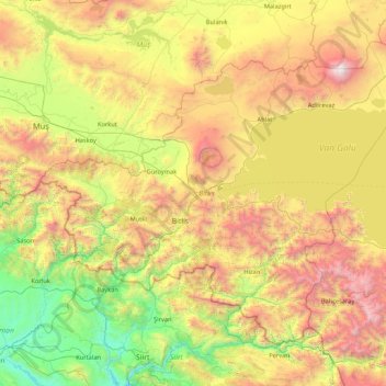
Name: Bitlis topographic map, elevation, terrain.
Location: Bitlis, Eastern Anatolia Region, Turkey (37.96924 41.48718 39.02407 43.19911)
Average elevation: 5,443 ft
Minimum elevation: 1,545 ft
Maximum elevation: 13,215 ft
Make a donation
Gear up for your next adventure:
As an Amazon Associate, this site earns from qualifying purchases at no extra cost to you.
Other topographic maps
Click on a map to view its topography, its elevation and its terrain.
Make a donation
Gear up for your next adventure:
As an Amazon Associate, this site earns from qualifying purchases at no extra cost to you.
Make a donation
Gear up for your next adventure:
As an Amazon Associate, this site earns from qualifying purchases at no extra cost to you.
Gaziantep
The plan introduced several important changes to the city's transportation network. One of the most important was the addition of a rail line to connect Gaziantep to the national rail system. Up to now, Turkish railway construction had ignored Gaziantep (partly because of its mountainous surroundings); a…
Average elevation: 2,887 ft
Make a donation
Gear up for your next adventure:
As an Amazon Associate, this site earns from qualifying purchases at no extra cost to you.
Make a donation
Gear up for your next adventure:
As an Amazon Associate, this site earns from qualifying purchases at no extra cost to you.
Make a donation
Gear up for your next adventure:
As an Amazon Associate, this site earns from qualifying purchases at no extra cost to you.
Mihalıççık
Turkey > Mihalıççık > Mihalıççık
Mihalıççık, also Mihalıçcık (English: Micalizo, sometimes Mihaliccik), is a town and district of Eskişehir Province in the Central Anatolia region of Turkey. According to 2010 census, population of the district is 10,482 of which 3,133 live in the town of Mihalıççık. The district covers an area of…
Average elevation: 4,213 ft
Make a donation
Gear up for your next adventure:
As an Amazon Associate, this site earns from qualifying purchases at no extra cost to you.
Make a donation
Gear up for your next adventure:
As an Amazon Associate, this site earns from qualifying purchases at no extra cost to you.
Make a donation
Gear up for your next adventure:
As an Amazon Associate, this site earns from qualifying purchases at no extra cost to you.
Make a donation
Gear up for your next adventure:
As an Amazon Associate, this site earns from qualifying purchases at no extra cost to you.
Make a donation
Gear up for your next adventure:
As an Amazon Associate, this site earns from qualifying purchases at no extra cost to you.
Make a donation
Gear up for your next adventure:
As an Amazon Associate, this site earns from qualifying purchases at no extra cost to you.
Make a donation
Gear up for your next adventure:
As an Amazon Associate, this site earns from qualifying purchases at no extra cost to you.
Make a donation
Gear up for your next adventure:
As an Amazon Associate, this site earns from qualifying purchases at no extra cost to you.
Make a donation
Gear up for your next adventure:
As an Amazon Associate, this site earns from qualifying purchases at no extra cost to you.
Make a donation
Gear up for your next adventure:
As an Amazon Associate, this site earns from qualifying purchases at no extra cost to you.
Make a donation
Gear up for your next adventure:
As an Amazon Associate, this site earns from qualifying purchases at no extra cost to you.
Make a donation
Gear up for your next adventure:
As an Amazon Associate, this site earns from qualifying purchases at no extra cost to you.
Marmaraereğlisi
Turkey > Marmaraereğlisi > Cedit Ali Paşa Mahallesi > Marmaraereğlisi
Average elevation: 39 ft
Make a donation
Gear up for your next adventure:
As an Amazon Associate, this site earns from qualifying purchases at no extra cost to you.