
Make a donation
Gear up for your next adventure:
As an Amazon Associate, this site earns from qualifying purchases at no extra cost to you.
Carson National Forest topographic map
Click on the map to display elevation.
Make a donation
Gear up for your next adventure:
As an Amazon Associate, this site earns from qualifying purchases at no extra cost to you.
About this map
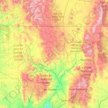
Name: Carson National Forest topographic map, elevation, terrain.
Location: Carson National Forest, New Mexico, United States (35.97255 -107.37237 37.00009 -105.01232)
Average elevation: 7,828 ft
Minimum elevation: 4,442 ft
Maximum elevation: 13,635 ft
New Mexico trails, hiking, mountain biking, running and outdoor activities
Make a donation
Gear up for your next adventure:
As an Amazon Associate, this site earns from qualifying purchases at no extra cost to you.
Other topographic maps
Click on a map to view its topography, its elevation and its terrain.
Make a donation
Gear up for your next adventure:
As an Amazon Associate, this site earns from qualifying purchases at no extra cost to you.
Make a donation
Gear up for your next adventure:
As an Amazon Associate, this site earns from qualifying purchases at no extra cost to you.
Make a donation
Gear up for your next adventure:
As an Amazon Associate, this site earns from qualifying purchases at no extra cost to you.
Raton Pass
United States > New Mexico > Colfax County
Ratón Pass is a 7,834 ft (2,388 m) elevation mountain pass on the Colorado–New Mexico border in the western United States. It is located on the eastern side of the Sangre de Cristo Mountains between Trinidad, Colorado and Raton, New Mexico, approximately 180 miles (290 km) northeast of Santa Fe. Ratón is…
Average elevation: 7,867 ft
Make a donation
Gear up for your next adventure:
As an Amazon Associate, this site earns from qualifying purchases at no extra cost to you.
Make a donation
Gear up for your next adventure:
As an Amazon Associate, this site earns from qualifying purchases at no extra cost to you.
Taos Ski Valley
United States > New Mexico > Taos County
Taos Ski Valley is a village and alpine ski resort in the southwestern United States, located in Taos County, New Mexico. The population was 69 at the 2010 census. Until March 19, 2008, it was one of four ski resorts in America to prohibit snowboarding. The Kachina lift, constructed in 2014, serves one of the…
Average elevation: 10,850 ft
Make a donation
Gear up for your next adventure:
As an Amazon Associate, this site earns from qualifying purchases at no extra cost to you.
Make a donation
Gear up for your next adventure:
As an Amazon Associate, this site earns from qualifying purchases at no extra cost to you.
Make a donation
Gear up for your next adventure:
As an Amazon Associate, this site earns from qualifying purchases at no extra cost to you.
Sandia Heights
United States > New Mexico > Bernalillo County > Albuquerque
Average elevation: 6,227 ft
Make a donation
Gear up for your next adventure:
As an Amazon Associate, this site earns from qualifying purchases at no extra cost to you.
Make a donation
Gear up for your next adventure:
As an Amazon Associate, this site earns from qualifying purchases at no extra cost to you.
Make a donation
Gear up for your next adventure:
As an Amazon Associate, this site earns from qualifying purchases at no extra cost to you.
Lake Farmington Recreation Area
United States > New Mexico > San Juan County > Farmington
Average elevation: 5,653 ft
Make a donation
Gear up for your next adventure:
As an Amazon Associate, this site earns from qualifying purchases at no extra cost to you.
Make a donation
Gear up for your next adventure:
As an Amazon Associate, this site earns from qualifying purchases at no extra cost to you.
Embudo Canyon
United States > New Mexico > Bernalillo County > Albuquerque
Average elevation: 6,096 ft
Make a donation
Gear up for your next adventure:
As an Amazon Associate, this site earns from qualifying purchases at no extra cost to you.
Make a donation
Gear up for your next adventure:
As an Amazon Associate, this site earns from qualifying purchases at no extra cost to you.
Los Alamos
United States > New Mexico > Los Alamos County > Los Alamos
Los Alamos is located in northern New Mexico between the Rio Grande and the eastern rim of the Valles Caldera on the Pajarito Plateau, approximately 35 mi (56 km) to the northwest of Santa Fe. The elevation at the post office is 7,320 feet (2,230 m) and total land area is 11.14 square miles (28.9 km2).
Average elevation: 7,205 ft
Las Cruces
United States > New Mexico > Doña Ana County > Las Cruces
The approximate elevation of Las Cruces is 3,908 feet (1,191 m) above sea level.
Average elevation: 4,314 ft
Make a donation
Gear up for your next adventure:
As an Amazon Associate, this site earns from qualifying purchases at no extra cost to you.
Make a donation
Gear up for your next adventure:
As an Amazon Associate, this site earns from qualifying purchases at no extra cost to you.
Cloudcroft
United States > New Mexico > Otero County > Cloudcroft
Cloudcroft is a village in Otero County, New Mexico, United States, and is located within the Lincoln National Forest. The population was 674 at the 2010 census. Despite being located in an otherwise arid region, its high elevation (8,676 feet (2,644 m); one of the highest in the U.S.) allows for a mild summer…
Average elevation: 8,648 ft
Make a donation
Gear up for your next adventure:
As an Amazon Associate, this site earns from qualifying purchases at no extra cost to you.
Sumner Lake State Park
United States > New Mexico > De Baca County
The park features a large 4,500-acre (18 km2) reservoir on the Pecos River, created in 1939 by the Sumner Dam of the United States Bureau of Reclamation. The reservoir is home to various fish species including largemouth bass, catfish, crappie and walleye. The park elevation is 4,300 feet (1,300 m) above sea…
Average elevation: 4,301 ft
Make a donation
Gear up for your next adventure:
As an Amazon Associate, this site earns from qualifying purchases at no extra cost to you.
Make a donation
Gear up for your next adventure:
As an Amazon Associate, this site earns from qualifying purchases at no extra cost to you.
Make a donation
Gear up for your next adventure:
As an Amazon Associate, this site earns from qualifying purchases at no extra cost to you.
Tierra Amarilla
United States > New Mexico > Rio Arriba County
The Brazos Cliffs are a prominent nearby landmark and attraction. Also nearby are the artificial Heron Lake and El Vado Lake. Tierra Amarilla's elevation is 7,524 feet above sea level.
Average elevation: 7,605 ft
Make a donation
Gear up for your next adventure:
As an Amazon Associate, this site earns from qualifying purchases at no extra cost to you.
Make a donation
Gear up for your next adventure:
As an Amazon Associate, this site earns from qualifying purchases at no extra cost to you.
Tres Piedras
United States > New Mexico > Taos County
Tres Piedras is located approximately 30 miles northwest of Taos, and west of the Rio Grande on U.S. Route 64. At approximately 8,000 feet (2,400 m) in altitude, it is located within the southern portion of the San Juan Range of the Rocky Mountains. Tres Piedras is on the western edge of a sagebrush plain,…
Average elevation: 8,123 ft
Make a donation
Gear up for your next adventure:
As an Amazon Associate, this site earns from qualifying purchases at no extra cost to you.
Make a donation
Gear up for your next adventure:
As an Amazon Associate, this site earns from qualifying purchases at no extra cost to you.