

Fayette County topographic map
Click on the map to display elevation.
About this map
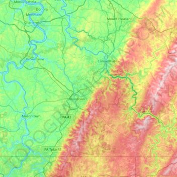
Name: Fayette County topographic map, elevation, terrain.
Location: Fayette County, Pennsylvania, United States (39.72066 -80.01050 40.14355 -79.29325)
Average elevation: 1,476 ft
Minimum elevation: 741 ft
Maximum elevation: 2,986 ft
Pennsylvania trails, hiking, mountain biking, running and outdoor activities
Other topographic maps
Click on a map to view its topography, its elevation and its terrain.

East Texas
United States > Pennsylvania > Lehigh County > Lower Macungie Township
Average elevation: 413 ft
Penn Valley
United States > Pennsylvania > Montgomery County > Lower Merion Township > Ardmore
Average elevation: 292 ft

Wheelerville
United States > Pennsylvania > Sullivan County > Fox Township
Average elevation: 2,178 ft
Hawk Mountain
United States > Pennsylvania > Berks County > Windsor Township
Average elevation: 1,142 ft
Breezewood
United States > Pennsylvania > Bedford County > East Providence Township
Average elevation: 1,355 ft

Leola
United States > Pennsylvania > Lancaster County > Upper Leacock Township
Average elevation: 374 ft
Albrightsville
United States > Pennsylvania > Carbon County > Kidder Township
Average elevation: 1,634 ft

Woodland Park
United States > Pennsylvania > Allegheny County > Pittsburgh > Sharpe Hill
Average elevation: 994 ft

Glenshaw
United States > Pennsylvania > Allegheny County > Shaler Township
Average elevation: 1,024 ft

Kunkletown
United States > Pennsylvania > Monroe County > Eldred Township
Kunkletown is an unincorporated community in Eldred Township, Monroe County, Pennsylvania, United States. It is located at an elevation of 531 feet. It is at ZIP Code 18058.
Average elevation: 735 ft

Narvon
United States > Pennsylvania > Lancaster County > Caernarvon Township
Average elevation: 751 ft
Haverford
United States > Pennsylvania > Montgomery County > Lower Merion Township
Average elevation: 341 ft

Scarlets Mill
United States > Pennsylvania > Berks County > Robeson Township
Average elevation: 492 ft


Lindberg Heights
United States > Pennsylvania > Montgomery County > Limerick Township > Limerick
Average elevation: 289 ft
Lords Valley
United States > Pennsylvania > Pike County > Blooming Grove Township
Average elevation: 1,352 ft
Coraopolis Heights
United States > Pennsylvania > Allegheny County > Findlay Township
Average elevation: 1,050 ft

Flight 93 National Memorial
United States > Pennsylvania > Somerset County > Stonycreek Township
Average elevation: 2,392 ft

South Park
United States > Pennsylvania > Allegheny County > South Park Township > Library
Average elevation: 1,099 ft

Douglass
United States > Pennsylvania > Allegheny County > Elizabeth Township
Average elevation: 981 ft

West Library
United States > Pennsylvania > Allegheny County > South Park Township > Library
Average elevation: 1,122 ft
Dingmans Ferry
United States > Pennsylvania > Pike County > Delaware Township
Average elevation: 630 ft
Mainesburg
United States > Pennsylvania > Tioga County > Sullivan Township
Average elevation: 1,565 ft

White Church
United States > Pennsylvania > Westmoreland County > North Huntingdon Township
Average elevation: 1,086 ft

Mount Nebo Park
United States > Pennsylvania > Monroe County > East Stroudsburg > Twin Falls
Average elevation: 607 ft
Russell
United States > Pennsylvania > Warren County > Pine Grove Township
Average elevation: 1,450 ft
Pricetown
United States > Pennsylvania > Berks County > Ruscombmanor Township
Average elevation: 784 ft
Cornwells Heights
United States > Pennsylvania > Bucks County > Bensalem Township
Average elevation: 52 ft
Cowden
United States > Pennsylvania > Washington County > Cecil Township > Cecil
Average elevation: 1,135 ft
Idaho
United States > Pennsylvania > Armstrong County > South Bend Township
Average elevation: 1,112 ft
Keown Station
United States > Pennsylvania > Allegheny County > Ross Township
Average elevation: 1,129 ft

Stony Creek Mills
United States > Pennsylvania > Berks County > Lower Alsace Township > Pennside
Average elevation: 630 ft
Riddlesburg
United States > Pennsylvania > Bedford County > Broad Top Township
Average elevation: 1,224 ft
New Enterprise
United States > Pennsylvania > Bedford County > South Woodbury Township
Average elevation: 1,302 ft
Blue Knob
United States > Pennsylvania > Bedford County > Pavia Township
Blue Knob (elevation 3,146 feet (959 m)) is a summit in the eastern United States with a broad dome that is the northernmost 3,000-footer in the Allegheny Mountains. It is the highest point in Bedford County, Pennsylvania.
Average elevation: 2,598 ft

Sinnemahoning
United States > Pennsylvania > Cameron County > Gibson Township
Average elevation: 1,332 ft
Saint Benedict
United States > Pennsylvania > Cambria County > West Carroll Township
Average elevation: 1,909 ft
English Center
United States > Pennsylvania > Lycoming County > Pine Township
Average elevation: 1,457 ft
Tyrrel Farm Corners
United States > Pennsylvania > Venango County > Allegheny Township
Average elevation: 1,568 ft
Orvilla
United States > Pennsylvania > Montgomery County > Hatfield Township
Average elevation: 328 ft

Rockville
United States > Pennsylvania > Dauphin County > Susquehanna Township
Average elevation: 463 ft
Fort Hunter
United States > Pennsylvania > Dauphin County > Middle Paxton Township
Average elevation: 489 ft
Fisherville
United States > Pennsylvania > Dauphin County > Jackson Township
Average elevation: 604 ft
Spring Run
United States > Pennsylvania > Franklin County > Fannett Township
Average elevation: 955 ft
Old Forge
United States > Pennsylvania > Franklin County > Quincy Township
Average elevation: 1,273 ft
Green Village
United States > Pennsylvania > Franklin County > Greene Township
Average elevation: 679 ft
Normalville
United States > Pennsylvania > Fayette County > Springfield Township
Average elevation: 1,594 ft
Chalkhill
United States > Pennsylvania > Fayette County > Wharton Township
Average elevation: 2,044 ft
Arnold City
United States > Pennsylvania > Fayette County > Washington Township
Average elevation: 994 ft
Three Tuns
United States > Pennsylvania > Montgomery County > Upper Dublin Township > Maple Glen
Average elevation: 331 ft
Hidden Valley
United States > Pennsylvania > Montgomery County > Upper Merion Township
Average elevation: 154 ft
Newfoundland
United States > Pennsylvania > Wayne County > Dreher Township
Average elevation: 1,496 ft
Worcester
United States > Pennsylvania > Montgomery County > Worcester Township
Average elevation: 305 ft
Strafford
United States > Pennsylvania > Chester County > Tredyffrin Township
Average elevation: 436 ft
West Pittsburg
United States > Pennsylvania > Lawrence County > Taylor Township
Average elevation: 915 ft
Pennsylvania Furnace
United States > Pennsylvania > Huntingdon County > Franklin Township
Average elevation: 1,191 ft
Dilltown
United States > Pennsylvania > Indiana County > East Wheatfield Township
Average elevation: 1,555 ft
Robinson
United States > Pennsylvania > Indiana County > West Wheatfield Township
Average elevation: 1,302 ft
Hazelton Mills
United States > Pennsylvania > McKean County > Bradford Township
Average elevation: 1,962 ft
Fogelsville
United States > Pennsylvania > Lehigh County > Upper Macungie Township
Average elevation: 509 ft
Tobyhanna
United States > Pennsylvania > Monroe County > Coolbaugh Township
Average elevation: 1,936 ft
Bear Rocks
United States > Pennsylvania > Fayette County > Bullskin Township
Average elevation: 1,873 ft
Barnesville
United States > Pennsylvania > Schuylkill County > Rush Township
Average elevation: 1,175 ft
Mount Bethel
United States > Pennsylvania > Northampton County > Upper Mount Bethel Township
Average elevation: 512 ft

Riddlewood
United States > Pennsylvania > Delaware County > Middletown Township
Average elevation: 259 ft
Rosemount
United States > Pennsylvania > York County > Spring Garden Township
Average elevation: 548 ft
Georgetown
United States > Pennsylvania > Armstrong County > Gilpin Township
Average elevation: 981 ft
Ruthfred Acres
United States > Pennsylvania > Allegheny County > Bethel Park
Average elevation: 1,142 ft
Reservoir Heights
United States > Pennsylvania > Dauphin County > Upper Paxton Township
Average elevation: 620 ft