
Make a donation
Gear up for your next adventure:
As an Amazon Associate, this site earns from qualifying purchases at no extra cost to you.
宝鸡市 topographic map
Click on the map to display elevation.
Make a donation
Gear up for your next adventure:
As an Amazon Associate, this site earns from qualifying purchases at no extra cost to you.
宝鸡市
宝鸡位于东经106°18′~108°03′和北纬33°35′~35°06′之间。东连咸阳,南接汉中,西北与甘肃省的天水和平凉毗邻。秦岭南屏,渭水中流,关陇西阻北横,渭北沃野平原。东西长156.6公里,南北宽160.6公里,总面积18117平方公里。宝鸡地质构造复杂,东、西、南、北、中的地貌差异大。具有南、西、北三面环山,只有东部敞开,大部分是丘陵地带。南部秦岭的主峰太白山是陕西最高点,海拔3767米。秦岭南边的河流属於长江水系,而北边是黄河水系。渭河是这里最大的河流,另外还有嘉陵江,千河,漆水河,石头河等。呈现“六山一水三分田”格局。
Make a donation
Gear up for your next adventure:
As an Amazon Associate, this site earns from qualifying purchases at no extra cost to you.
About this map
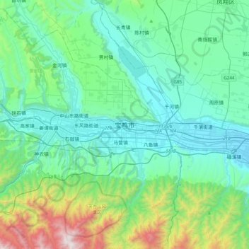
Name: 宝鸡市 topographic map, elevation, terrain.
Location: 宝鸡市, 金台区, 宝鸡市, 陕西省, 中国 (34.20458 107.07322 34.52458 107.39322)
Average elevation: 2,930 ft
Minimum elevation: 1,745 ft
Maximum elevation: 8,051 ft
Make a donation
Gear up for your next adventure:
As an Amazon Associate, this site earns from qualifying purchases at no extra cost to you.
Other topographic maps
Click on a map to view its topography, its elevation and its terrain.
Make a donation
Gear up for your next adventure:
As an Amazon Associate, this site earns from qualifying purchases at no extra cost to you.