
金陵街道 topographic map
Interactive map
Click on the map to display elevation.
About this map
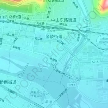
Name: 金陵街道 topographic map, elevation, terrain.
Location: 金陵街道, 渭滨区, 宝鸡市, 陕西省, 中国 (34.36065 107.13766 34.37544 107.16153)
Average elevation: 1,955 ft
Minimum elevation: 1,886 ft
Maximum elevation: 2,566 ft
Other topographic maps
Click on a map to view its topography, its elevation and its terrain.