
Hemnes topographic map
Interactive map
Click on the map to display elevation.
About this map
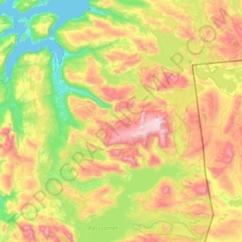
Name: Hemnes topographic map, elevation, terrain.
Location: Hemnes, Nordland, Norway (65.76583 13.33380 66.25693 14.60231)
Average elevation: 2,005 ft
Minimum elevation: -3 ft
Maximum elevation: 6,102 ft
Other topographic maps
Click on a map to view its topography, its elevation and its terrain.
Haukland Beach
Haukland Beach, Sjøbakken, Vestvågøy, Nordland, Norway
Average elevation: 338 ft
Ballangen - Bálák
Ballangen - Bálák, Narvik, Nordland, Norway
Average elevation: 299 ft
Sulitjelma - Sulisjielmmá
Sulitjelma - Sulisjielmmá, Fauske, Nordland, Norway
Average elevation: 1,243 ft