
Hadsel topographic map
Interactive map
Click on the map to display elevation.
About this map
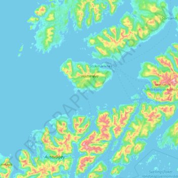
Name: Hadsel topographic map, elevation, terrain.
Location: Hadsel, Nordland, Norway (68.31908 14.13608 68.68797 15.44285)
Average elevation: 331 ft
Minimum elevation: -7 ft
Maximum elevation: 3,950 ft
Other topographic maps
Click on a map to view its topography, its elevation and its terrain.
Haukland Beach
Haukland Beach, Sjøbakken, Vestvågøy, Nordland, Norway
Average elevation: 338 ft
Ballangen - Bálák
Ballangen - Bálák, Narvik, Nordland, Norway
Average elevation: 299 ft
Sulitjelma - Sulisjielmmá
Sulitjelma - Sulisjielmmá, Fauske, Nordland, Norway
Average elevation: 1,243 ft