
Moskenes topographic map
Interactive map
Click on the map to display elevation.
About this map
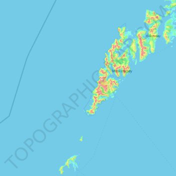
Name: Moskenes topographic map, elevation, terrain.
Location: Moskenes, Nordland, Norway (67.67407 12.16660 68.15245 13.69498)
Average elevation: 59 ft
Minimum elevation: -3 ft
Maximum elevation: 3,287 ft
Other topographic maps
Click on a map to view its topography, its elevation and its terrain.
Haukland Beach
Haukland Beach, Sjøbakken, Vestvågøy, Nordland, Norway
Average elevation: 338 ft
Ballangen - Bálák
Ballangen - Bálák, Narvik, Nordland, Norway
Average elevation: 299 ft
Sulitjelma - Sulisjielmmá
Sulitjelma - Sulisjielmmá, Fauske, Nordland, Norway
Average elevation: 1,243 ft