
Make a donation
Gear up for your next adventure:
As an Amazon Associate, this site earns from qualifying purchases at no extra cost to you.
El Milagro topographic map
Click on the map to display elevation.
Make a donation
Gear up for your next adventure:
As an Amazon Associate, this site earns from qualifying purchases at no extra cost to you.
About this map
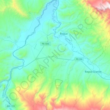
Name: El Milagro topographic map, elevation, terrain.
Location: El Milagro, Utcubamba, Amazonas, Perú (-5.87086 -78.69253 -5.53804 -78.53362)
Average elevation: 2,484 ft
Minimum elevation: 1,178 ft
Maximum elevation: 7,608 ft
Make a donation
Gear up for your next adventure:
As an Amazon Associate, this site earns from qualifying purchases at no extra cost to you.
Other topographic maps
Click on a map to view its topography, its elevation and its terrain.
Laguna Pomacochas
Perú > Amazonas > El Porvenir
Laguna de Pomacochas es una laguna peruana, situada en el departamento de Amazonas. Está situada a una altitud de unos 2257 metros (7.405 pies), tiene aproximadamente 2,79 kilómetros de largo y 2 km en su punto más ancho. La laguna se encuentra al este de la ciudad de Pomacochas, que también…
Average elevation: 7,349 ft
Make a donation
Gear up for your next adventure:
As an Amazon Associate, this site earns from qualifying purchases at no extra cost to you.
Make a donation
Gear up for your next adventure:
As an Amazon Associate, this site earns from qualifying purchases at no extra cost to you.
Chachapoyas
Perú > Amazonas > Chachapoyas
Esta ciudad se ubica a una altitud de 2.483 m s. n. m., en el nor-oriente peruano, cerca al río Utcubamba.
Average elevation: 7,480 ft
Make a donation
Gear up for your next adventure:
As an Amazon Associate, this site earns from qualifying purchases at no extra cost to you.
Make a donation
Gear up for your next adventure:
As an Amazon Associate, this site earns from qualifying purchases at no extra cost to you.
Make a donation
Gear up for your next adventure:
As an Amazon Associate, this site earns from qualifying purchases at no extra cost to you.
Make a donation
Gear up for your next adventure:
As an Amazon Associate, this site earns from qualifying purchases at no extra cost to you.
Make a donation
Gear up for your next adventure:
As an Amazon Associate, this site earns from qualifying purchases at no extra cost to you.
Make a donation
Gear up for your next adventure:
As an Amazon Associate, this site earns from qualifying purchases at no extra cost to you.
Make a donation
Gear up for your next adventure:
As an Amazon Associate, this site earns from qualifying purchases at no extra cost to you.
Make a donation
Gear up for your next adventure:
As an Amazon Associate, this site earns from qualifying purchases at no extra cost to you.
Make a donation
Gear up for your next adventure:
As an Amazon Associate, this site earns from qualifying purchases at no extra cost to you.
Puerto Galilea
Perú > Amazonas > Río Santiago
Puerto Galilea es una localidad peruana ubicada en la región Amazonas, provincia de Condorcanqui, distrito de Río Santiago. Es asimismo capital del distrito de Río Santiago. Se encuentra a una altitud de 192 m s. n. m. Tenía una población de 440 habitantes en 1993.
Average elevation: 600 ft
Make a donation
Gear up for your next adventure:
As an Amazon Associate, this site earns from qualifying purchases at no extra cost to you.