
大理镇 topographic map
Interactive map
Click on the map to display elevation.
About this map
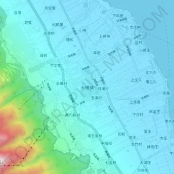
Name: 大理镇 topographic map, elevation, terrain.
Location: 大理镇, 大理市, 大理白族自治州, 云南省, 671003, 中国 (25.65730 100.12517 25.73730 100.20517)
Average elevation: 6,929 ft
Minimum elevation: 6,437 ft
Maximum elevation: 11,017 ft
大理镇位于大理市西部,西倚苍山,东临洱海。辖区东西横距12千米,南北纵距10.1千米,总面积76.48平方千米。大理镇地势西高东低。最高点位于玉局峰,海拔4,097.6米,最低点位于洱海旁,海拔1,966米。森林覆盖率46.72%,耕地面积2,173.5公顷。
Other topographic maps
Click on a map to view its topography, its elevation and its terrain.