
Guácimo topographic map
Click on the map to display elevation.
About this map
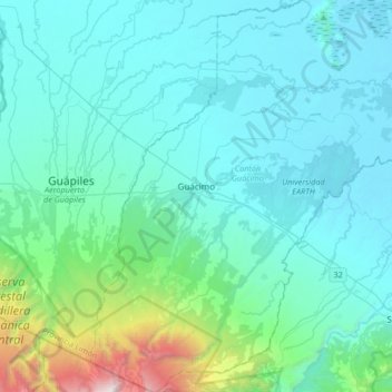
Name: Guácimo topographic map, elevation, terrain.
Location: Guácimo, Limón, Costa Rica (10.03871 -83.77532 10.40430 -83.34198)
Average elevation: 1,060 ft
Minimum elevation: 0 ft
Maximum elevation: 10,801 ft
Other topographic maps
Click on a map to view its topography, its elevation and its terrain.
San José
Costa Rica > Cantón de San José
Con una extensión de 4462 km² y una elevación de 1300 m s. n. m. el territorio que hoy ocupa la ciudad de San José está formado por un terreno fértil y llano con leves ondulaciones, una altitud estable y rodeado de montañas en el centro del llamado Valle Central.
Average elevation: 4,488 ft
Río Jesús
Costa Rica > Alajuela > Cantón de San Ramón > San Rafael > Berlín
Average elevation: 4,091 ft
Colonia Cubujuquí (Sector B)
Costa Rica > Cantón Sarapiquí > Las Horquetas
Average elevation: 1,050 ft
San Rafael Norte
Costa Rica > Cantón Pérez Zeledón > San Isidro de El General
Average elevation: 2,989 ft
Volcán Irazú
Costa Rica > Oreamuno > Santa Rosa
El volcán Irazú es un volcán en escudo activo ubicado en Costa Rica, en la Cordillera Volcánica Central, en el interior del parque nacional que lleva su nombre, a unos 32 km al norte de la ciudad de Cartago. Su cima, a una altitud de 3432 m s. n. m., y que lo hace el volcán más alto de Costa Rica, se…
Average elevation: 10,217 ft
Gloria
Costa Rica > Provincia de Alajuela > Cantón de San Carlos > Aguas Zarcas
Average elevation: 233 ft
Plaza de la Democracia y de la Abolición del Ejército
Costa Rica > Cantón de San José > San José
Average elevation: 3,816 ft
Parque de Cascajal
Costa Rica > Cantón de Vázquez de Coronado > Cascajal > Cascajal
Average elevation: 5,738 ft
Mirador del Valle General
Costa Rica > Cantón de Pérez Zeledón > Páramo > Hortencia
Average elevation: 5,052 ft