
Make a donation
Gear up for your next adventure:
As an Amazon Associate, this site earns from qualifying purchases at no extra cost to you.
Harar topographic map
Click on the map to display elevation.
Make a donation
Gear up for your next adventure:
As an Amazon Associate, this site earns from qualifying purchases at no extra cost to you.
About this map
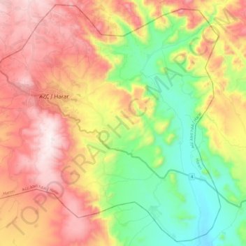
Name: Harar topographic map, elevation, terrain.
Location: Harar, Ethiopia (9.18695 42.05981 9.38969 42.27297)
Average elevation: 5,607 ft
Minimum elevation: 4,203 ft
Maximum elevation: 7,182 ft
Make a donation
Gear up for your next adventure:
As an Amazon Associate, this site earns from qualifying purchases at no extra cost to you.
Other topographic maps
Click on a map to view its topography, its elevation and its terrain.
Addis Ababa
Ethiopia > Addis Ababa > Arada
Moreover, the city held strong social organizations pattern prior Italian invasion. According to Richard Pankhurst (1968), the city accelerated population growth due to factors of provisional governors and their troops, the 1892 famine, eventually the Battle of Adwa. Another include the 1907 land act,…
Average elevation: 8,258 ft
Debre Birhan
Debre Birhan (Amharic: ደብረ ብርሃን) is a city in central Ethiopia. Located in the Semien Shewa Zone of Amhara Region, about 120 kilometers north east of Addis Ababa on Ethiopian highway 2, the town has an elevation of 2,840 meters, which makes it the highest town in Africa. It was an early capital…
Average elevation: 8,924 ft
Make a donation
Gear up for your next adventure:
As an Amazon Associate, this site earns from qualifying purchases at no extra cost to you.
Alamata
Alamata (Tigrinya: ኣላማጣ ) is a town in the Tigray Region of Ethiopia. Located in the Debubawi (Southern) zone of Tigray it has a latitude and longitude of 12°25′N 39°33′E / 12.417°N 39.550°E / 12.417; 39.550 and an elevation of 1,520 metres (4,990 ft) above sea level and is located…
Average elevation: 5,164 ft
Dilla
Ethiopia > South Ethiopia Regional State
Dilla (Amharic: ዲላ) is a market town and separate woreda in southern Ethiopia. The administrative center of the Gedeo Zone in the former Southern Nations, Nationalities, and Peoples Region (SNNPR) now it is South Ethiopia Regional State (SER), it is located on the main road from Addis Ababa to Nairobi. The…
Average elevation: 6,188 ft
Make a donation
Gear up for your next adventure:
As an Amazon Associate, this site earns from qualifying purchases at no extra cost to you.
Ogaden Desert
The Ogaden is a plateau, with an elevation above sea level that ranges from 1,500 metres (4,900 ft) in the northwest, falling to about 300 metres (980 ft) along the southern limits and the Wabi Shebelle valley. The areas with altitudes between 1,400 and 1,600 metres (4,600 and 5,200 ft) are characterised as…
Average elevation: 1,916 ft
Boditi
Ethiopia > South Ethiopia Regional State
Boditi, (Amharic: ቦዲቲ) or (Wolayttattuwa: Bodditte) is a city and separate district in south central Ethiopia. The city is located in the Wolaita Zone of the South Ethiopia Regional State. This city has a latitude and longitude of 6°58′N 37°52′E / 6.967°N 37.867°E / 6.967; 37.867 with an…
Average elevation: 6,503 ft
Dilla
Ethiopia > South Ethiopia Regional State
Dilla (Amharic: ዲላ) is a market town and separate woreda in southern Ethiopia. The administrative center of the Gedeo Zone in the former Southern Nations, Nationalities, and Peoples Region (SNNPR) now it is South Ethiopia Regional State (SER), it is located on the main road from Addis Ababa to Nairobi. The…
Average elevation: 6,188 ft
Make a donation
Gear up for your next adventure:
As an Amazon Associate, this site earns from qualifying purchases at no extra cost to you.
Addis Ababa
Ethiopia > Addis Ababa > Arada
Addis Ababa (/ˌædɪs ˈæbəbə/ AD-iss AB-ə-bə; Amharic: አዲስ አበባ [adˈdis ˈaβəβa] , lit. 'new flower'; Oromo: Finfinnee, lit. 'fountain of hot mineral water') is the capital city of Ethiopia. With an estimated population of 2,739,551 inhabitants as of the 2007 census, it is the largest…
Average elevation: 8,258 ft
Make a donation
Gear up for your next adventure:
As an Amazon Associate, this site earns from qualifying purchases at no extra cost to you.
Demebecha
Dembecha is a town in northwestern Ethiopia 349 km north of Addis Ababa. Located in the Mirab Gojjam Zone of the Amhara Region, this town has a latitude and longitude of 10°33′N 37°29′E / 10.550°N 37.483°E / 10.550; 37.483 with an elevation of 2083 meters above sea level. It is one of three…
Average elevation: 6,972 ft
Make a donation
Gear up for your next adventure:
As an Amazon Associate, this site earns from qualifying purchases at no extra cost to you.
Entoto
Ethiopia > Oromia Region > Sululta
The Ethiopian Heritage Trust, a non-profit, non-governmental organization, is working actively to change part of the mountain to its old state, a natural park. Entoto Natural Park is the northeastern rim of Addis Abeba, on the southeastern slopes of Mt. Entoto, covering an area of 1,300 hectares. It is…
Average elevation: 9,905 ft
Make a donation
Gear up for your next adventure:
As an Amazon Associate, this site earns from qualifying purchases at no extra cost to you.
Make a donation
Gear up for your next adventure:
As an Amazon Associate, this site earns from qualifying purchases at no extra cost to you.
Hossana
Ethiopia > Central Ethiopia Regional State
Hosaena, Hossana or Hosaina is a town which level as a woreda in southern Ethiopia, and currently serve as the administrative center of Hadiya Zone and Central Ethiopia Regional State as well. Geographically located to the central south of Ethiopia, with a latitude and longitude of 7°33′N 37°51′E /…
Average elevation: 7,398 ft
Asosa
Ethiopia > Benishangul-Gumuz Region
Asosa or Assosa is the capital of Benishangul-Gumuz Region, Ethiopia. Located in the Asosa Zone, this town has a latitude and longitude of 10°04′N 34°31′E / 10.067°N 34.517°E / 10.067; 34.517, with an elevation of 1,570 meters.
Average elevation: 4,268 ft
Mekoni
Mekoni, also Mehoni (Ge'ez: መኾኒ or መሆኒ), is a town in the Tigray Region of Ethiopia. "Mekoni" (pronounced as 'Me-koni') is located at 657 km north of Addis Ababa along Ethiopian Highway 2 which runs to Mekelle (the capital city of Tigray region), Adigrat, Aksum, Shire and Humera with an altitude of 2479 m.
Average elevation: 5,925 ft
Make a donation
Gear up for your next adventure:
As an Amazon Associate, this site earns from qualifying purchases at no extra cost to you.
Lake Hawassa
Lake Hawassa or Awasa, is an endorheic basin in Sidama Region of Ethiopia, located in the Main Ethiopian Rift south of Addis Ababa, the capital city of the country. According to the Statistical Abstract of Ethiopia for 1967/68, the lake is 16 km long and 9 km wide, with a surface area of 129 square kilometers.…
Average elevation: 5,594 ft
Bombe
Ethiopia > South Ethiopia Regional State
Bombe (Geʽez: ቦምቤ) is a town and separate district in Wolayita Zone of the South Ethiopia Regional State, Ethiopia. Bombe town is located 325 km (202 mi) and 55 km (34 mi) away from Addis Ababa and Wolaita Sodo town through Hossana exit, respectively. Bombe town is used as an administrative capital of…
Average elevation: 4,977 ft
Make a donation
Gear up for your next adventure:
As an Amazon Associate, this site earns from qualifying purchases at no extra cost to you.
Make a donation
Gear up for your next adventure:
As an Amazon Associate, this site earns from qualifying purchases at no extra cost to you.
Naqamte
Nekemte, also spelled as Neqemte (Oromo: Naqamtee, Amharic: ነቀምት), is a market city and separate woreda in western Ethiopia. Located in the East Welega Zone of the Oromia Region, Nekemte has a latitude and longitude of 9°5′N 36°33′E / 9.083°N 36.550°E / 9.083; 36.550 and an elevation of 2,088 meters.
Average elevation: 6,263 ft
Holeta Genet
Ethiopia > Oromia Region > Walmara
Holeta (Amharic: ሆለታ) (Oromo: Holataa) is a town in the special zone of Oromia Region, Ethiopia. It has a latitude and longitude of 9°3′N 38°30′E / 9.050°N 38.500°E / 9.050; 38.500 and an altitude of 2391 meters above sea level.
Average elevation: 7,844 ft
Make a donation
Gear up for your next adventure:
As an Amazon Associate, this site earns from qualifying purchases at no extra cost to you.
Hawassa
Hawassa (Amharic: አዋሳ; ʾäwasa, also spelled Awassa or Awasa) known historically as Adare is a city in Ethiopia, on the shores of Lake Hawassa in the Great Rift Valley. It is 273 km (170 mi) south of Addis Ababa via Bishoftu, 130 km (81 mi) east of Sodo, and 75 km (47 mi) north of Dilla. The town serves…
Average elevation: 6,109 ft
Gambela
Gambela (Amharic: ጋምቤላ), also spelled Gambella, is a city and separate woreda in Ethiopia and the capital of the Gambela Region. Located in Anyuak Zone, at the confluence of the Baro River and its tributary the Jajjabe, the city has a latitude and longitude of 8°15′N 34°35′E / 8.250°N…
Average elevation: 1,870 ft
Make a donation
Gear up for your next adventure:
As an Amazon Associate, this site earns from qualifying purchases at no extra cost to you.
Make a donation
Gear up for your next adventure:
As an Amazon Associate, this site earns from qualifying purchases at no extra cost to you.
Abiy Addi
Abiy Addi has an elevation ranging from 1917 to 2275 meters above sea level. From the higher to the lower locations, the following geological formations are present: Ashangi Basalts, Amba Aradam Formation, Adigrat Sandstone, and Edaga Arbi Glacials.
Average elevation: 6,421 ft
Hagere Selam
Hagere Selam (Tigrinya: ሃገረ ሰላም) is a town in northern Ethiopia. Located on the Mekelle-Abiy Addi regional road, it is located at an elevation of 2650 metres above sea level. The town is the administrative center of the Dogu'a Tembien woreda. The weekly market is on Saturdays.
Average elevation: 8,025 ft
Make a donation
Gear up for your next adventure:
As an Amazon Associate, this site earns from qualifying purchases at no extra cost to you.
Agaro
Agaro (also spelled Haggaro) (Oromo: Aggaaroo) is a town and separate woreda in south-western Ethiopia. Located in the Jimma Zone of the Oromia Region, it sits at an elevation of 1,560 meters above sea level.
Average elevation: 5,502 ft
Asela
Asella (Oromo: Asallaa, Amharic: አሰላ) is a town in central Ethiopia. Located in the Arsi Zone of the Oromia Region 126 km (78 mi) south from Addis Ababa, this town has a latitude and longitude of 7°57′N 39°7′E / 7.950°N 39.117°E / 7.950; 39.117, with an elevation of 2,430 meters. Asella…
Average elevation: 7,969 ft
Make a donation
Gear up for your next adventure:
As an Amazon Associate, this site earns from qualifying purchases at no extra cost to you.
Moyale
Moyale has a hot semi-arid climate (Köppen BSh) moderated somewhat by altitude. Typically for East Africa, there are two rainy seasons: the “long rains” from March to May and the weaker, less reliable “short rains” in October and November.
Average elevation: 3,593 ft
Make a donation
Gear up for your next adventure:
As an Amazon Associate, this site earns from qualifying purchases at no extra cost to you.
Make a donation
Gear up for your next adventure:
As an Amazon Associate, this site earns from qualifying purchases at no extra cost to you.
Make a donation
Gear up for your next adventure:
As an Amazon Associate, this site earns from qualifying purchases at no extra cost to you.
Chiro
Chiro (also called Asebe Teferi or Asba Littoria; Afaan Oromo: Ciroo) is a town and Aanaa in eastern Ethiopia. Located in the West Hararghe Zone in Oromia Regional State, Ethiopia Ahmar Mountains, it has a latitude and longitude of 9°05′N 40°52′E / 9.083°N 40.867°E / 9.083; 40.867 and an…
Average elevation: 6,135 ft
Make a donation
Gear up for your next adventure:
As an Amazon Associate, this site earns from qualifying purchases at no extra cost to you.
Metu
Metu (Oromo: Mattuu) is a market town and separate woreda in south-western Ethiopia. Located in the Illubabor Zone of the Oromia along the Sor River, this town has a latitude and longitude of 8°18′N 35°35′E / 8.300°N 35.583°E / 8.300; 35.583 and an altitude of 1605 meters. Metu was the capital…
Average elevation: 5,518 ft
Make a donation
Gear up for your next adventure:
As an Amazon Associate, this site earns from qualifying purchases at no extra cost to you.
Make a donation
Gear up for your next adventure:
As an Amazon Associate, this site earns from qualifying purchases at no extra cost to you.
Turmi
Ethiopia > South Ethiopia Regional State
Turmi is a market town in south-western Ethiopia. Located in the Debub Omo Zone of the South Ethiopia Regional State, the town has a latitude and longitude of 4°58′N 36°29′E / 4.967°N 36.483°E / 4.967; 36.483 with an elevation of 925 metres above sea level.
Average elevation: 3,022 ft
Make a donation
Gear up for your next adventure:
As an Amazon Associate, this site earns from qualifying purchases at no extra cost to you.
Hawassa
Hawassa (Amharic: አዋሳ; ʾäwasa, also spelled Awassa or Awasa) known historically as Adare is a city in Ethiopia, on the shores of Lake Awassa in the Great Rift Valley. It is 273 km (170 mi) south of Addis Ababa via Bishoftu, 130 km (81 mi) east of Sodo, and 75 km (47 mi) north of Dilla. The town serves…
Average elevation: 6,109 ft
Addis Ababa
Ethiopia > Addis Ababa > Arada
Moreover, the city held strong social organization patterns prior to the Italian invasion. According to Richard Pankhurst (1968), the city's accelerated population growth was due to factors of provisional governors and their troops, the 1892 famine, and eventually the Battle of Adwa. Another includes the 1907…
Average elevation: 8,258 ft
Make a donation
Gear up for your next adventure:
As an Amazon Associate, this site earns from qualifying purchases at no extra cost to you.
Sendafa
Sendafa (Oromo: Sandafaa) is a town and separate woreda in Oromia Region, Ethiopia. Its name is taken from the Oromo name for a kind of thick, jointed grass or reed which grows in swampy areas. Located in the Oromia Special Zone Surrounding Finfinne of the Oromia Region, Sendafa has a latitude and longitude of…
Average elevation: 8,510 ft
Make a donation
Gear up for your next adventure:
As an Amazon Associate, this site earns from qualifying purchases at no extra cost to you.
Nech Sar National Park
Ethiopia > South Ethiopia Regional State > Arba Minch
Average elevation: 3,986 ft
Make a donation
Gear up for your next adventure:
As an Amazon Associate, this site earns from qualifying purchases at no extra cost to you.