Geolocate

Torriglia topographic map

Click on the map to display elevation.

About this map

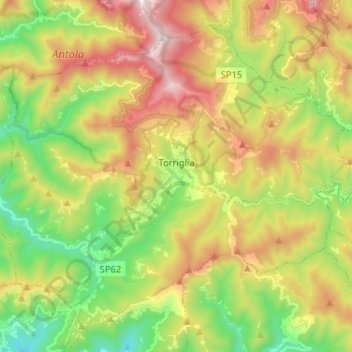
Name: Torriglia topographic map, elevation, terrain.

Location: Torriglia, Genoa, Liguria, 16029, Italy (44.47653 9.09130 44.55518 9.22023)

Average elevation: 2,815 ft

Minimum elevation: 1,401 ft

Maximum elevation: 4,701 ft

Other topographic maps

Click on a map to view its topography, its elevation and its terrain.

Brignole

Italy > Liguria > Genoa > Rezzoaglio

Average elevation: 3,120 ft

Genoa

Italy > Liguria > Genoa > Genoa

The city of Genoa covers an area of 243 square kilometres (94 sq mi) between the Ligurian Sea and the Apennine Mountains. The city stretches along the coast for about 30 kilometres (19 mi) from the neighbourhood of Voltri to Nervi, and for 10 kilometres (6.2 mi) from the coast to the north along the valleys…

Average elevation: 810 ft

Gear up for your next adventure:

🧯Emergency Survival Kit - All‑in‑one survival essentials for the backcountry
🔥Plasma Lighters - Windproof lighters that work in any weather condition
🗻Climbing Gear Basics - Essential gear for beginner climbers
🧴Hand Sanitizer - Keep hands clean while hiking
🪶Camp Gear Gift Set - Perfect gift bundle for outdoor fans

As an Amazon Associate, this site earns from qualifying purchases at no extra cost to you.