
Make a donation
Gear up for your next adventure:
As an Amazon Associate, this site earns from qualifying purchases at no extra cost to you.
Juárez topographic map
Click on the map to display elevation.
Make a donation
Gear up for your next adventure:
As an Amazon Associate, this site earns from qualifying purchases at no extra cost to you.
About this map
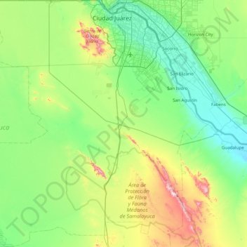
Name: Juárez topographic map, elevation, terrain.
Location: Juárez, Chihuahua, Mexico (31.11996 -106.95163 31.78390 -106.18088)
Average elevation: 4,098 ft
Minimum elevation: 3,560 ft
Maximum elevation: 5,889 ft
Make a donation
Gear up for your next adventure:
As an Amazon Associate, this site earns from qualifying purchases at no extra cost to you.
Other topographic maps
Click on a map to view its topography, its elevation and its terrain.
Ciudad Juárez
Due to its location in the Chihuahuan Desert and high altitude, Ciudad Juárez has a cold desert climate (Köppen: BWk). Seasons are distinct, with hot summers, mild springs and autumns, and cold winters. Summer average high is 35 °C (95 °F) with lows of 21 °C (70 °F). Winter highs average 14 °C (57 °F)…
Average elevation: 3,970 ft
Make a donation
Gear up for your next adventure:
As an Amazon Associate, this site earns from qualifying purchases at no extra cost to you.
Ciudad Juárez
Due to its location in the Chihuahuan Desert and high altitude, Ciudad Juárez has a cold desert climate (Köppen: BWk). Seasons are distinct, with hot summers, mild springs and autumns, and cold winters. Summer average high is 35 °C (95 °F) with lows of 21 °C (70 °F). Winter highs average 14 °C (57 °F)…
Average elevation: 4,029 ft
Chihuahua City
Mexico > Chihuahua > Municipio de Chihuahua
Chihuahua lies on the western side of the Chihuahuan Desert ecoregion and as such has a hot semi-arid climate (Köppen climate classification BSh). However, it is not as hot as most of the lower elevated portions of the desert to the east owing to an altitude of almost 1,500 metres (4,900 feet) above sea level.
Average elevation: 5,102 ft
Make a donation
Gear up for your next adventure:
As an Amazon Associate, this site earns from qualifying purchases at no extra cost to you.
Ejido Tabalaopa
Mexico > Chihuahua > Municipio de Chihuahua > Chihuahua City
Average elevation: 4,528 ft
Make a donation
Gear up for your next adventure:
As an Amazon Associate, this site earns from qualifying purchases at no extra cost to you.
Make a donation
Gear up for your next adventure:
As an Amazon Associate, this site earns from qualifying purchases at no extra cost to you.
Make a donation
Gear up for your next adventure:
As an Amazon Associate, this site earns from qualifying purchases at no extra cost to you.
Make a donation
Gear up for your next adventure:
As an Amazon Associate, this site earns from qualifying purchases at no extra cost to you.
Parque El Reliz
Mexico > Chihuahua > Municipio de Chihuahua > Chihuahua City
Average elevation: 4,885 ft
Chihuahua City
Mexico > Chihuahua > Municipio de Chihuahua
Chihuahua lies on the western side of the Chihuahuan Desert ecoregion and as such has a hot semi-arid climate (Köppen climate classification BSh). However, it is not as hot as most of the lower elevated portions of the desert to the east owing to an altitude of almost 1,500 metres (4,900 feet) above sea level.
Average elevation: 5,102 ft
Make a donation
Gear up for your next adventure:
As an Amazon Associate, this site earns from qualifying purchases at no extra cost to you.
Make a donation
Gear up for your next adventure:
As an Amazon Associate, this site earns from qualifying purchases at no extra cost to you.
Chihuahua City
Mexico > Chihuahua > Municipio de Chihuahua
Chihuahua lies on the western side of the Chihuahuan Desert ecoregion and as such has a semiarid climate (Köppen climate classification BSh). However, it is not as hot as most of the lower elevated portions of the desert to the east owing to an altitude of almost 1,500 metres (4,900 feet) above sea level.
Average elevation: 5,102 ft
Parque Cactus del Desierto
Mexico > Chihuahua > Municipio de Juárez > Ciudad Juárez
Average elevation: 3,980 ft
Make a donation
Gear up for your next adventure:
As an Amazon Associate, this site earns from qualifying purchases at no extra cost to you.
Make a donation
Gear up for your next adventure:
As an Amazon Associate, this site earns from qualifying purchases at no extra cost to you.
Make a donation
Gear up for your next adventure:
As an Amazon Associate, this site earns from qualifying purchases at no extra cost to you.
Make a donation
Gear up for your next adventure:
As an Amazon Associate, this site earns from qualifying purchases at no extra cost to you.