
徐闻县 topographic map
Interactive map
Click on the map to display elevation.
About this map
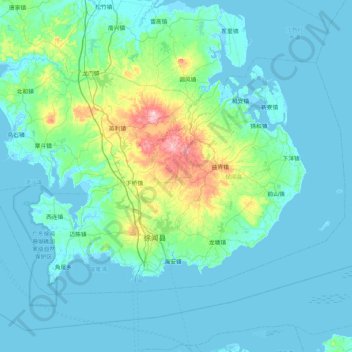
Name: 徐闻县 topographic map, elevation, terrain.
Location: 徐闻县, 湛江市, 广东省, 中国 (20.20035 109.78638 20.72914 110.62511)
Average elevation: 92 ft
Minimum elevation: -13 ft
Maximum elevation: 840 ft
Other topographic maps
Click on a map to view its topography, its elevation and its terrain.