
Make a donation
Gear up for your next adventure:
As an Amazon Associate, this site earns from qualifying purchases at no extra cost to you.
宿松县 topographic map
Click on the map to display elevation.
Make a donation
Gear up for your next adventure:
As an Amazon Associate, this site earns from qualifying purchases at no extra cost to you.
About this map
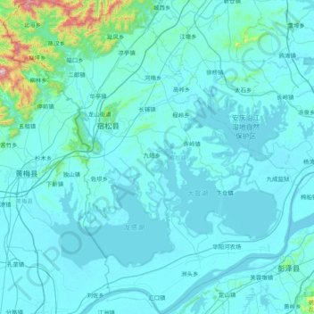
Name: 宿松县 topographic map, elevation, terrain.
Location: 宿松县, 安庆市, 安徽省, 中国 (29.78396 115.87898 30.43063 116.58075)
Average elevation: 207 ft
Minimum elevation: 16 ft
Maximum elevation: 3,675 ft
Make a donation
Gear up for your next adventure:
As an Amazon Associate, this site earns from qualifying purchases at no extra cost to you.
Other topographic maps
Click on a map to view its topography, its elevation and its terrain.
Make a donation
Gear up for your next adventure:
As an Amazon Associate, this site earns from qualifying purchases at no extra cost to you.
Make a donation
Gear up for your next adventure:
As an Amazon Associate, this site earns from qualifying purchases at no extra cost to you.
Make a donation
Gear up for your next adventure:
As an Amazon Associate, this site earns from qualifying purchases at no extra cost to you.
Make a donation
Gear up for your next adventure:
As an Amazon Associate, this site earns from qualifying purchases at no extra cost to you.
Make a donation
Gear up for your next adventure:
As an Amazon Associate, this site earns from qualifying purchases at no extra cost to you.
广德市
广德市位于皖南山地与沿江平原的过渡带。广德所处的地区曾在海底,两亿多年前从海中逐渐出露,后经过几次强烈的地质活动,形成了特殊的地形环境和复杂的地貌格局。广德市南部以低山为主,山间发育峡谷,山地组成的岩性差异较大,有二长花岗岩、石英岩、砂岩、粉砂岩、石灰岩等;中部以岗地、河谷平原为主,相间分布,构成了广德盆地,市内河流都由此向西北流出,入郎溪县境内;北部以丘陵为主,仅皖、苏、浙接壤处有低山蜿蜒,组成丘陵的岩性与南部低山相似,但该处石灰岩质纯层厚,发育了典型的亚热带地下喀斯特溶洞。最高点为南部的马鞍山,海拔863.3米,最低点为西北边缘的狮子口,海拔14.5米。
Average elevation: 315 ft
Make a donation
Gear up for your next adventure:
As an Amazon Associate, this site earns from qualifying purchases at no extra cost to you.
Make a donation
Gear up for your next adventure:
As an Amazon Associate, this site earns from qualifying purchases at no extra cost to you.
Make a donation
Gear up for your next adventure:
As an Amazon Associate, this site earns from qualifying purchases at no extra cost to you.
Make a donation
Gear up for your next adventure:
As an Amazon Associate, this site earns from qualifying purchases at no extra cost to you.
黄山市
黄山市位于“八山一水一分田”的皖南山区,境内多深山、峡谷,黄山山脉横贯歙县、黄山区、休宁、黟县之间,最高峰莲花峰海拔1860米。市域东南的天目山为安徽、浙江两省界山。西北的牯牛降为黄山余脉,最高峰海拔1728米。新安江为市内主要水系,为钱塘江正源,源出休宁县境内,流经祁门县,复入休宁以后称率水,在屯溪与横江并流后,称为渐江,流至歙县,练江来汇,始称新安江,东流至街口镇附近后进入浙江省。黄山市境内还有发源于黄山北坡的青弋江,北流入长江,发源于祁门县的阊江,南流入鄱阳湖。黄山区境内、青弋江上游有太平湖,为人工水库,是黄山北麓著名景点和湿地公园。
Average elevation: 889 ft
Make a donation
Gear up for your next adventure:
As an Amazon Associate, this site earns from qualifying purchases at no extra cost to you.
Make a donation
Gear up for your next adventure:
As an Amazon Associate, this site earns from qualifying purchases at no extra cost to you.
Make a donation
Gear up for your next adventure:
As an Amazon Associate, this site earns from qualifying purchases at no extra cost to you.
Make a donation
Gear up for your next adventure:
As an Amazon Associate, this site earns from qualifying purchases at no extra cost to you.
Make a donation
Gear up for your next adventure:
As an Amazon Associate, this site earns from qualifying purchases at no extra cost to you.
Make a donation
Gear up for your next adventure:
As an Amazon Associate, this site earns from qualifying purchases at no extra cost to you.
Make a donation
Gear up for your next adventure:
As an Amazon Associate, this site earns from qualifying purchases at no extra cost to you.
Make a donation
Gear up for your next adventure:
As an Amazon Associate, this site earns from qualifying purchases at no extra cost to you.
池州市
池州市域地形为东南高、西北低,自南向北呈阶梯分布,江河湖水面348.4平方公里,占总面积的4%。长江流经池州145km,岸线长162km,上起江西省彭泽县接壤的东至县牛矶,下讫铜陵市交界的青通河口。境内有三大水系十条河流,长江水系有尧渡河、黄湓河、秋浦河、白洋河、大通河、九华河;青弋江水系有清溪河、陵阳河、喇叭河;鄱阳湖水系有龙泉河。流域面积在500平方公里以上的有七条河流,河长618km,其中秋浦河为境内流域中最长的一条河,流域面积3019平方公里,河长149km。池州市地表水资源丰富,全市水资源总量为63.7亿立方米,占全省水资源总量的11%,人均水资源量4326 立方米,分别是安徽省和全国平均水平的4倍和2倍…
Average elevation: 161 ft
Make a donation
Gear up for your next adventure:
As an Amazon Associate, this site earns from qualifying purchases at no extra cost to you.
Make a donation
Gear up for your next adventure:
As an Amazon Associate, this site earns from qualifying purchases at no extra cost to you.
Make a donation
Gear up for your next adventure:
As an Amazon Associate, this site earns from qualifying purchases at no extra cost to you.
Make a donation
Gear up for your next adventure:
As an Amazon Associate, this site earns from qualifying purchases at no extra cost to you.
Make a donation
Gear up for your next adventure:
As an Amazon Associate, this site earns from qualifying purchases at no extra cost to you.
Make a donation
Gear up for your next adventure:
As an Amazon Associate, this site earns from qualifying purchases at no extra cost to you.
Make a donation
Gear up for your next adventure:
As an Amazon Associate, this site earns from qualifying purchases at no extra cost to you.
Make a donation
Gear up for your next adventure:
As an Amazon Associate, this site earns from qualifying purchases at no extra cost to you.