
Horseshoe Bend topographic map
Interactive map
Click on the map to display elevation.
About this map
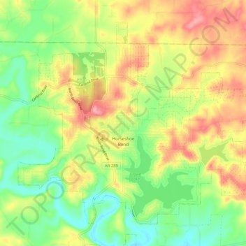
Name: Horseshoe Bend topographic map, elevation, terrain.
Location: Horseshoe Bend, Izard County, Arkansas, 72512, United States (36.19148 -91.79236 36.26120 -91.68736)
Average elevation: 709 ft
Minimum elevation: 525 ft
Maximum elevation: 932 ft
The Horseshoe Bend Airport, FAA identifier is 6M2, is owned and operated by the city. The runway is 4,524 ft. x 60 ft. and is paved. It is located at 36°13′3″N 91°45′3″W / 36.21750°N 91.75083°W / 36.21750; -91.75083 (36.2213694, -91.7554833) at an elevation of 782 ft. / 238 m. Its variation is 03E.
Other topographic maps
Click on a map to view its topography, its elevation and its terrain.
Mount Olive
United States > Arkansas > Izard County
Mount Olive, Izard County, Arkansas, United States
Average elevation: 479 ft
Pineville
United States > Arkansas > Izard County
Pineville, Izard County, Arkansas, 72566, United States
Average elevation: 653 ft
Lunenburg
United States > Arkansas > Izard County
Lunenburg, Izard County, Arkansas, United States
Average elevation: 525 ft
Oxford
United States > Arkansas > Izard County
Oxford, Izard County, Arkansas, 72565, United States
Average elevation: 761 ft
Gid
United States > Arkansas > Izard County
Gid, Izard County, Arkansas, United States
Average elevation: 643 ft
Guion
United States > Arkansas > Izard County
Guion, Izard County, Arkansas, 72540, United States
Average elevation: 466 ft
Zion
United States > Arkansas > Izard County
Zion, Izard County, Arkansas, 72573, United States
Average elevation: 650 ft
Wideman
United States > Arkansas > Izard County
Wideman, Izard County, Arkansas, 72585, United States
Average elevation: 627 ft
Sylamore
United States > Arkansas > Izard County
Sylamore, Izard County, Arkansas, 72050, United States
Average elevation: 531 ft
Jumbo
United States > Arkansas > Izard County
Jumbo, Izard County, Arkansas, United States
Average elevation: 604 ft
Dolph
United States > Arkansas > Izard County
Dolph, Izard County, Arkansas, 72528, United States
Average elevation: 823 ft
Franklin
United States > Arkansas > Izard County
Franklin, Izard County, Arkansas, United States
Average elevation: 666 ft
Wiseman
United States > Arkansas > Izard County
Wiseman, Izard County, Arkansas, 72587, United States
Average elevation: 650 ft
Forty Four
United States > Arkansas > Izard County
Forty Four, Izard County, Arkansas, 72585, United States
Average elevation: 581 ft
Violet Hill
United States > Arkansas > Izard County
Violet Hill, Izard County, Arkansas, 72584, United States
Average elevation: 761 ft
Sage
United States > Arkansas > Izard County
Sage, Izard County, Arkansas, 72573, United States
Average elevation: 735 ft
Horseshoe Bend
United States > Arkansas > Izard County > Horseshoe Bend
Horseshoe Bend, Izard County, Arkansas, 72512, United States
Average elevation: 722 ft
Melbourne
United States > Arkansas > Izard County
Melbourne, Izard County, Arkansas, 72556, United States
Average elevation: 659 ft
Mount Pleasant
United States > Arkansas > Izard County
Mount Pleasant, Izard County, Arkansas, 72561, United States
Average elevation: 673 ft
Calico Rock
United States > Arkansas > Izard County
Calico Rock, Izard County, Arkansas, United States
Average elevation: 587 ft
LaCrosse
United States > Arkansas > Izard County
LaCrosse, Izard County, Arkansas, 72584, United States
Average elevation: 741 ft